If Shenandoah National Park maintained a list of park trails ranked by the number of hikers who travel them, the Onemile Run Trail would very likely be at the bottom of the list - among the least hiked trails in the park. Several factors contribute to the lack of use on this trail. The best view on the entire hike is from your car before you even start the hike. Additionally, this hike is not part of a loop, but requires an out and back hike, as there is no public access from outside of the park. And it is in the Southern District of the Park, which is less utilized than the Central or Northern Districts. Therefore, unless you hike with a group, you are less likely to see other users than on nearly any trail in the Park.
But there are great reasons to check this trail out! If you are looking for a beautiful hike with few other hikers and lots of stream crossings, or if you would like to backpack into an area that is more pristine than the more popular Big Run drainage just to the south, or if you would like to see a healthy stand of hemlocks, check this trail out. (Remember that SNP backcountry regulations prohibit campfires or camping within 10 yards of a stream or 20 yards from a park trail). Along this hike, there is near constant evidence of the April, 2016 fire that raged through this part of the park.
Because of the number of stream crossings, do not attempt this trail after unusually wet periods. And if you do camp, be sure to check for “widowmakers” when placing a tent: trees that are weakened or dead and could flatten your tent overnight!
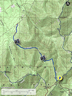
- Mile 0.0 – Park at the Twomile Run Overlook on the Skyline Drive. At 2700 feet elevation, your car sits near the high point of this hike, so you will have a long uphill hike at the end of your journey. Travel south along the Skyline Drive to a concrete post that signals the beginning of the Onemile Run Trail. Heading north from parking takes you to the trailhead for the Rocky Mount/Gap Run Trail.
- Mile 0.1 – The trail starts by heading uphill, but this does not last long. After cresting at about 2850 feet elevation, the trail starts dropping steeply over the next 1.25 miles until it reaches Onemile Run more than 1000 feet below, and follows the stream that forms the valley. Follow the trail along Twomile Ridge.
- Mile 1.1 – The trail leaves Twomile Ridge and heads down to Onemile Run, the stream that creates this valley.
- Mile 1.4 – Cross a side tributary of Onemile Run, the first of 13 stream crossings each way on this hike.
- Mile 1.5 – Reach Onemile Run and immediately cross, only to cross back to the other side about 300 feet further down the trail.
- Mile 1.7 – Repeat as necessary: two more stream crossings within 200 feet of each other. Look for a stand of healthy hemlocks along here, reportedly only one of two stands in Shenandoah National Park treated for the Hemlock woolly adelgid infestation that has killed so many hemlocks in Virginia.
- Mile 1.8 – Cross back to the north side of the stream, and then return about 500 feet later. There are multiple opportunities to camp along this section of trail, but there are no established campsites. There is no need for a fire ring, though, because of the campfire prohibition. Be sure to check for trees that might come down at night if setting up a tent or hammock! There are nice rock formations visible during this part of the hike.
- Mile 2.1 – Cross the stream again, and continue alternating the sides of the stream for several more crossings. Each one can be an adventure! (Expect wet feet by the end of this hike if your boots are not waterproof.) The trail is never far from the stream. The valley will start to open up as the ridges on each side begin to recede. You will hike near a talus slope, located just to the right of the trail.
- Mile 2.6 – There is small waterfall hidden from the trail on the left.
- Mile 2.9 – Cross the stream for the twelfth time, and move to the south side of the stream.
- Mile 3.0 – Reach the thirteenth and final stream crossing (in this direction). From here to the park border, the trail leaves Onemile Run and traverses through woods that show evidence of the 2016 fire. This part of the hike is less interesting, and only recommended if you want to say you’ve hiked this entire trail.
- Mile 3.8 – A concrete mileage post signals the park boundary. Although the trail appears blazed further than this point, this is the end of public property, so we advise you to turn around here. Return via the same route.
- Mile 6.2 – After again crossing Onemile Run many times, the trail again leaves the valley and begins climbing back to the trailhead. You better have saved some energy! Over the next 1.25 miles, you will need to climb over 1000 feet to get out of this valley.
- Mile 7.8 – Reach the Skyline Drive. Walk north (left) along the Drive to return to your vehicle.
- Mile 7.9 – Return to your vehicle.