Loading...

Distance:
2.2 Miles / 3.5 km
Type:
Out-and-Back
Difficulty:
Easy
Time to Hike:
1 hour, ~6 minutes
Features:
Surface Type:
Dirt
Park:
Olympic National Forest
Town:
Quinault, Washington
Directions:
47.460173, -123.861934
Added:
March 18, 2017
Updated:
June 06, 2018
Loading...
Loading...
65 '

Total Change
364 '

Ascent
365 '

Descent

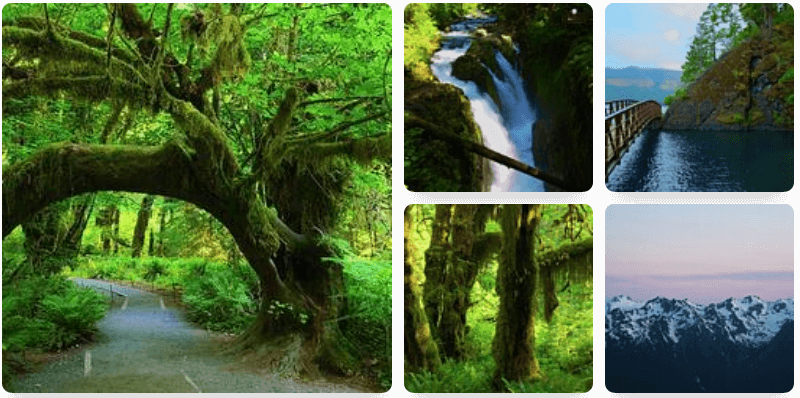
The Lake Shore Trail at Olympic National Forest, WA, is an easy 2.2 mile out-and-back hike that brings you along Lake Quinault.

This trail leads from the northwest corner of the Rain Forest Nature Trail, thus requiring an extra 0.2 - 0.3 miles in addition to the 2.2 out-and-back miles.

When I did this trail in mid March 2017, the lake's water level was so high that it flooded the trail, so the GPS data provided is only 1.1 miles out-and-back, instead of the full length of the trail at 2.2 miles out-and-back.

When you're heading northeast on the trail and come out by the campground, follow the campground's road (stay left) until you reach campsite #6. Just beyond campsite #6 is the continuation of this trail.

Explore 6 trails near Quinault, WA
  1. Parking

    47.460173, -123.861934
  2. Main Trailhead

    47.460423, -123.860713
No community routes found. To add your own hike as a Community Route for this Trail guide, leave a Trip Report with an attached GPX file.

Season

Spring

Photo Albums

1 Trip Report

No Star-Ratings
Trail Guide By:
Admin user profile picture
2.2 miles / 3.5 km
Trail added
March 18, 2017
Hiked on
March 18, 2017
Updated on
June 06, 2018

Weather Forecast

In Quinault, WA

Explore Hiking Trails

New Hikes

Catawba Falls Trail
2.9 Miles
4.7 km
Moderate
Out-and-Back
Gorge Trail (Stony Brook)
0.8 Miles
1.3 km
Moderate
One-Way
Lower Stony Brook Falls
0.2 Miles
0.3 km
Easy
Out-and-Back
Mary's Lake Trail
0.6 Miles
1 km
Easy
Out-and-Back

Before you boogie...

Find our trail guides useful? Consider becoming a Supporter to unlock perks!

MyHikes is an indie platform that makes exploring public trails easier for everyone. The platform has no investors, runs no ads, and is owned and operated by one person, Dave Miller. Dave has personally mapped and written over 1,600 trail guides on MyHikes for the public to explore. As of 2024, MyHikes has helped over 1,300,000 outdoor enthusiasts plan their next adventure.

But it takes a lot of time 🕦, money 💰, and work, and espresso shots ☕ to run MyHikes, including hiking , mapping , writing , and publishing new trails with high-quality (accurate) information... along with software engineering (coding) the platform like building new features, site and mobile app development for iOS and Android, site maintainance . and much much more.

Supporters unlock website and mobile app perks with an annual one-time payment of $25 (you renew) 😎👍. Or you can simply make a Donation of your choice. Otherwise, you can support us by telling your friends about MyHikes - both quick and free 🎉

Admin user profile picture

Dave Miller
MyHikes Founder