Loading...

Old Mine Falls

Directions
Map
Pictures
Send to App
Distance:
0 Miles / 0 km
Type:
Out-and-Back
Difficulty:
Easy
Time to Hike:
~5 minutes
Features:
Surface Type:
Universal Access
Park:
Delaware Water Gap National Recreation Area
Town:
Walpack Township, New Jersey
Directions:
41.138515, -74.920218
Added:
December 12, 2023
Updated:
December 19, 2023
Copy Trail Link Hiking this trail? Send a friend or family member a link to this trail guide for your own safety. Hike at your own risk (disclaimer)
Loading...

Download the Trail Route for Offline Use

Supporters get exclusive access to download trail routes to the MyHikes app for offline use. Stay prepared on your adventure, even without an internet connection! Become a Supporter today to unlock this feature and hike with confidence.

Send to App

Old Mine Falls

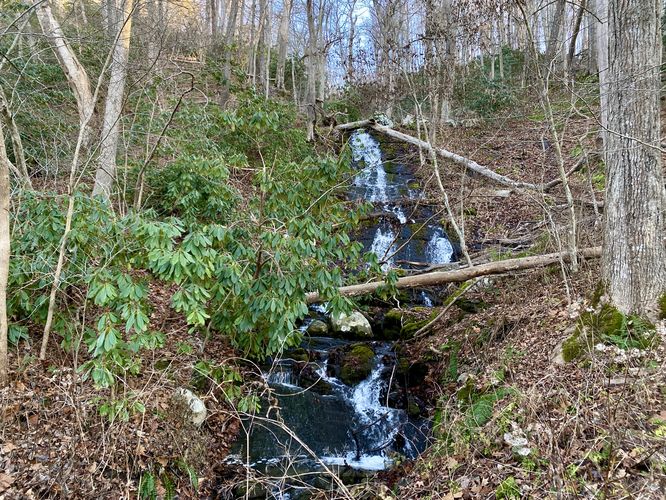
Old Mine Falls at Delaware Water Gap National Recreation Area near Walpack Township, New Jersey is a 30-foot roadside waterfall.

This is not a hike but rather a roadside stop along Old Mine Road in Delaware Water Gap to reach the base of Old Mine Falls, a waterfall that cascades down the hillside at about 30-feet tall in total. Visitors don't even need to get out of their car to enjoy this waterfall, if you wish to drive by slowly -- or safely stop along the road when there's no traffic. To play it safe, you can pull over along the road and walk back to the bridge where Old Mine Falls cascades adjacent to.

Universal Access
Note that due to the fact that visitors can enjoy this waterfall from their vehicle, this roadside stop should be considered universally accessible.

Parking
If you wish to walk down the road, visitors can pull off the road near the coordinates provided, located along Old Mine Road, to walk back to the waterfall. There are no designated parking turnouts for this waterfall, as of December 2023.

Warning
Roadside walking: If you choose to leave your vehicle for this roadside stop, walk the road at your own risk.
Explore 13 trails near Walpack Township, NJ
  1. Parking

    41.138515, -74.920218
  2. Main Trailhead

    41.138535, -74.920135
  3. Old Mine Falls, approx. 30-feet tall

    41.138625, -74.919751
    Old Mine Falls, approx. 30-feet tall
No community routes found. To add your own hike as a Community Route for this Trail guide, leave a Trip Report with an attached GPX file.

Hazards

Ticks - Lyme Disease More Info (CDC)

Seasons

All

Weather Forecast

In Walpack Township, NJ

Explore Hiking Trails

You May Also Like

Colorado's Million Dollar Highway - Plan a day's drive adventure along the iconic Million Dollar Highway in Colorado. Explore the best short trails, roadside stops, waterfalls, vistas, ghost towns, and hot springs within a ~6 hour road trip.
Explore

Colorado's Million Dollar Highway

Plan a day's drive adventure along the iconic Million Dollar Highway in Colorado. Explore the best short trails, roadside stops, waterfalls, vistas, ghost towns, and hot springs within a ~6 hour road trip.

Read
Glacier's Going-to-the-Sun Road - Discover the breathtaking beauty of Glacier National Park along the iconic Going-to-the-Sun Road. From stunning roadside stops to picturesque waterfalls and vistas, this engineering marvel offers endless opportunities for exploration.
Explore

Glacier's Going-to-the-Sun Road

Discover the breathtaking beauty of Glacier National Park along the iconic Going-to-the-Sun Road. From stunning roadside stops to picturesque waterfalls and vistas, this engineering marvel offers endless opportunities for exploration.

Read
New York's Best Waterfalls - Whether you're planning a day hike, roadside stop, or a leisurely short walk, this guide provides hikers, travelers, and locals alike with 63 different locations to over 100 scenic waterfalls to help plan your next adventure!
Explore

New York's Best Waterfalls

Whether you're planning a day hike, roadside stop, or a leisurely short walk, this guide provides hikers, travelers, and locals alike with 63 different locations to over 100 scenic waterfalls to help plan your next adventure!

Read

Before you boogie...

Find our trail guides useful? Consider becoming a Supporter to unlock perks!

MyHikes is an indie platform that makes exploring public trails easier for everyone. The platform has no investors, no ads, and is owned and operated by one person, Dave Miller. Dave has personally mapped and written over 1,800 trail guides on MyHikes for the public to explore. MyHikes has helped millions outdoor enthusiasts plan their next adventure.

But it takes a lot of time ๐Ÿ•ฆ, money ๐Ÿ’ฐ, work, and espresso shots โ˜• to run MyHikes, including hiking , mapping , writing , and publishing new trails with high-quality (accurate) information... along with software engineering (coding) the platform like building new features, website and mobile app development (iOS and Android), site maintainance . and much much more.

Supporters unlock website and mobile app perks with an annual one-time payment of $25 (you renew) ๐Ÿ˜Ž๐Ÿ‘. Or you can simply make a Donation of your choice. Otherwise, you can support us by telling your friends about MyHikes - both quick and free ๐ŸŽ‰

Admin user profile picture

Dave Miller
MyHikes Founder