Loading...

๐ŸŽ‰ Enjoy a Free 7-Day Supporter Trial and Unlock Exclusive Perks โ€” No Credit Card Required. Learn more.

Old Jelly Mill Falls

Directions
Map
Pictures
Send to App
Distance:
0.2 Miles / 0.3 km
Type:
Out-and-Back
Difficulty:
Easy
Time to Hike:
~6 minutes
Features:
Surface Type:
Dirt
Town:
Dummerston, Vermont
Directions:
42.914739, -72.614903
Added:
July 12, 2024
Updated:
July 29, 2024
Copy Trail Link Hiking this trail? Send a friend or family member a link to this trail guide for your own safety. Hike at your own risk (disclaimer)
Loading...
Loading...
40'

Total Change
42'

Ascent
42'

Descent

Download the Trail Route for Offline Use

Supporters get exclusive access to download trail routes to the MyHikes app for offline use. Stay prepared on your adventure, even without an internet connection! Become a Supporter today to unlock this feature and hike with confidence.

Send to App

Old Jelly Mill Falls

Old Jelly Mill Falls in Dummerston, Vermont is an easy 0.2-mile out-and-back hike that features several waterfalls in Stickney Brook, including a beautiful 8-foot tall cascade.

Walk
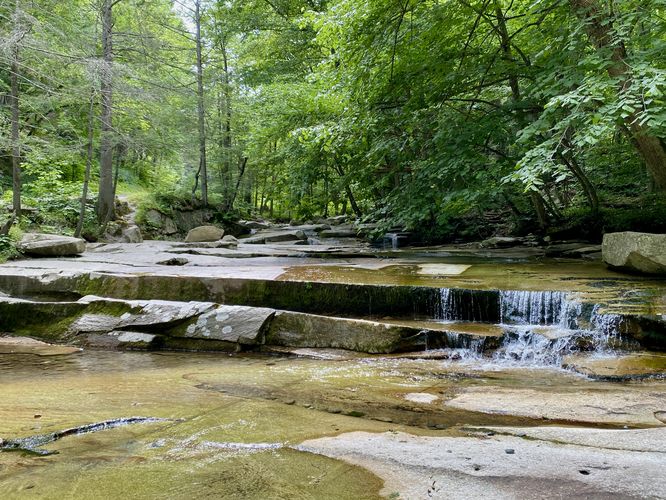
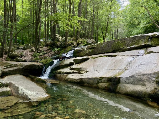
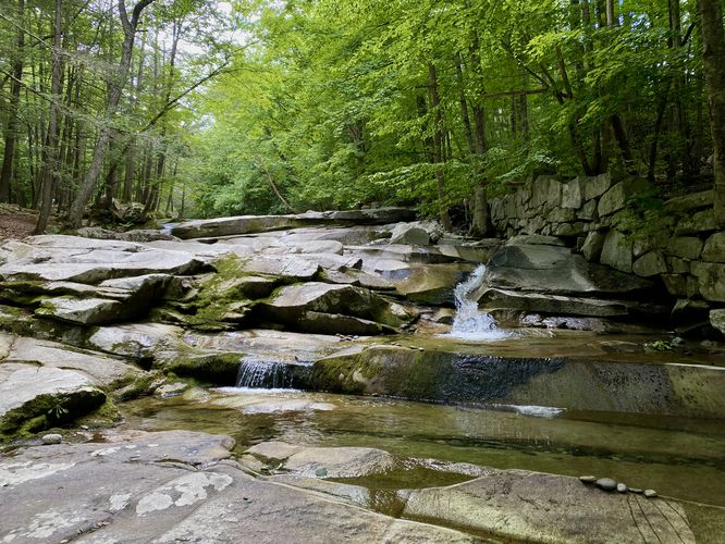
This is not a hike, but rather a short walk that runs along Stickney Brook to reach a few waterfalls within the creek, known as Old Jelly Mill Falls. The trail begins along the north side of Stickney Brook Road and heads into the creek to reach Upper Jelly Mill Falls, which is a very short ~2-foot rock shelf waterfall. Just below is Middle Old Jelly Mill Falls, which cascades down the bedrock at about 8-feet tall or so. Middle Old Jelly Mill Falls has the largest pool of water below and was the most-scenic cascade along this walk. Just below is Lower Old Jelly Mill Falls which is a multi-tiered waterfall with small cascades that spill down the brook. Finally. hikers will find a couple of tiny cascades below before the trail ends. The trail then leads back up to parking for a short 0.2-mile out-and-back walk.

Parking
Visitors will find small parking turnouts along the north side of Stickney Brook Road in Dummerston, Vermont. The turnouts are large enough to fit less than a dozen vehicles as of July 2024.

Pets
Dogs are allowed only if leashed and should be cleaned up.
Explore 44 trails near Dummerston, VT
  1. Parking

    42.914739, -72.614903
  2. Main Trailhead

    42.914744, -72.614822
  3. Upper Jelly Mill Falls

    42.915006, -72.614844
    Upper Jelly Mill Falls
  4. Middle Old Jelly Mill Falls

    42.915031, -72.614372
    Middle Old Jelly Mill Falls
  5. Lower Jelly Mill Falls

    42.915044, -72.614089
    Lower Jelly Mill Falls
No community routes found. To add your own hike as a Community Route for this Trail guide, leave a Trip Report with an attached GPX file.

Hazards

Ticks - Lyme Disease More Info (CDC)
Poison Ivy/Oak

Seasons

All

Photo Albums

Trip Reports

Trail Guide By:
Admin user profile picture
0.2 miles / 0.3 km
0.2 miles / 0.3 km
July 12, 2024
Dogs Hiking

Weather Forecast

In Dummerston, VT

Explore Hiking Trails

You May Also Like

Colorado's Million Dollar Highway - Plan a day's drive adventure along the iconic Million Dollar Highway in Colorado. Explore the best short trails, roadside stops, waterfalls, vistas, ghost towns, and hot springs within a ~6 hour road trip.
Explore

Colorado's Million Dollar Highway

Plan a day's drive adventure along the iconic Million Dollar Highway in Colorado. Explore the best short trails, roadside stops, waterfalls, vistas, ghost towns, and hot springs within a ~6 hour road trip.

Read
Glacier's Going-to-the-Sun Road - Discover the breathtaking beauty of Glacier National Park along the iconic Going-to-the-Sun Road. From stunning roadside stops to picturesque waterfalls and vistas, this engineering marvel offers endless opportunities for exploration.
Explore

Glacier's Going-to-the-Sun Road

Discover the breathtaking beauty of Glacier National Park along the iconic Going-to-the-Sun Road. From stunning roadside stops to picturesque waterfalls and vistas, this engineering marvel offers endless opportunities for exploration.

Read
New York's Best Waterfalls - Whether you're planning a day hike, roadside stop, or a leisurely short walk, this guide provides hikers, travelers, and locals alike with 63 different locations to over 100 scenic waterfalls to help plan your next adventure!
Explore

New York's Best Waterfalls

Whether you're planning a day hike, roadside stop, or a leisurely short walk, this guide provides hikers, travelers, and locals alike with 63 different locations to over 100 scenic waterfalls to help plan your next adventure!

Read

Before you boogie...

Find our trail guides useful? Consider becoming a Supporter to unlock perks!

MyHikes is an indie platform that makes exploring public trails easier for everyone. The platform has no investors, no ads, and is owned and operated by one person, Dave Miller. Dave has personally mapped and written over 1,800 trail guides on MyHikes for the public to explore. MyHikes has helped millions outdoor enthusiasts plan their next adventure.

But it takes a lot of time ๐Ÿ•ฆ, money ๐Ÿ’ฐ, work, and espresso shots โ˜• to run MyHikes, including hiking , mapping , writing , and publishing new trails with high-quality (accurate) information... along with software engineering (coding) the platform like building new features, website and mobile app development (iOS and Android), site maintainance . and much much more.

Supporters unlock website and mobile app perks with an annual one-time payment of $25 (you renew) ๐Ÿ˜Ž๐Ÿ‘. Or you can simply make a Donation of your choice. Otherwise, you can support us by telling your friends about MyHikes - both quick and free ๐ŸŽ‰

Admin user profile picture

Dave Miller
MyHikes Founder