Loading...

WINTER SALE! 50% OFF Supporter Accounts — now through January 31st. Learn More.

Ogdensburg Falls

Ogdensburg Falls in Blossburg, Pennsylvania is an easy 0.1-mile out-and-back roadside walk that leads to a private 15-foot multi-tiered waterfall known as Ogdenburg Falls.

Private Property
Please note that this waterfall sits on private property. The waterfall can be enjoyed from the road, which is public, but do not enter the property or attempt to hike up the waterfall. Only enjoy this waterfall from the public land of the road, thanks!

Walk
This is not a hike but rather a short roadside walk that begins on the Northeast side of Ogdenburg Road in Blossburg, located 0.4-miles south from Morris Run Road. There's a large parking turnout located here where you can park.
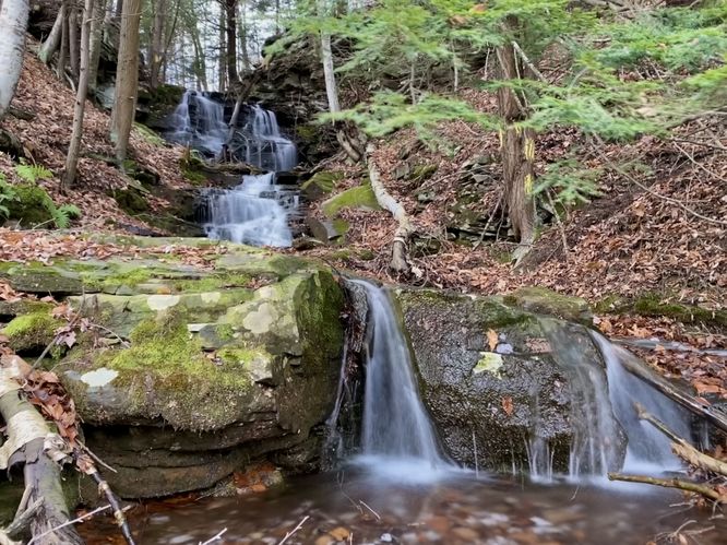
Ogdenburg Falls
Cross the road from the parking turnout and you'll find the 15-foot multi-tiered Ogdenburg Falls cascading down the hillside's bedrock. The upper tier is about 8-feet tall at most with a middle tier at about 5-feet and the lowest tier is about 3-feet tall. The waterfall is best viewed after heavy rains or snow melt.

Parking
There's a very large parking turnout at the coordinates provided, located on the Northeast side of Ogdenburg Road in Blossburg, only 0.4-miles south from Morris Run Road.

Pets
Dogs are allowed on public roads and should be leashed and cleaned up after.
Explore 267 trails near Blossburg, PA

Know Before You Go

  • Ogdensburg Falls is a 15-foot multi-tiered waterfall in Blossburg, PA, accessible via a short 0.1-mile roadside walk.
  • The waterfall is located on private property, so viewing is limited to the public road and entering the property is prohibited.
  • Parking is available in a large turnout on the Northeast side of Ogdenburg Road, and dogs are allowed on the road if leashed and cleaned up after.
Interactive topographic map for Ogdensburg Falls located in Blossburg, PA. Click the "View Map" button to load GPS coordinates and trail markers.
Get directions
Distance
0.1 mi
Difficulty
Easy
Type
Out-and-Back
Est. Time
5 min
Elev. Gain
1'
Rating
0.0
Added
November 23, 2023
Updated
January 05, 2024

Weather Forecast

Tonight
Low 0°F
Chance Snow Showers
Wednesday
High 12°F
Chance Snow Showers then Mostly Sunny
Wednesday Night
Low -1°F
Mostly Cloudy
Thursday
High 13°F
Mostly Sunny
Thursday Night
Low -5°F
Partly Cloudy
Friday
High 9°F
Mostly Sunny
Friday Night
Low -8°F
Partly Cloudy
Saturday
High 12°F
Partly Sunny
Saturday Night
Low 3°F
Mostly Cloudy
Sunday
High 17°F
Slight Chance Snow Showers
Sunday Night
Low 7°F
Partly Cloudy
Monday
High 25°F
Mostly Sunny
Monday Night
Low 8°F
Mostly Cloudy
Tuesday
High 23°F
Partly Sunny
Loading...
Total Change
1'
Ascent
1'
Descent
1'
Loading...

Download the GPX Data for Offline Use

Supporters get exclusive access to download trail routes to the MyHikes app for offline use. Stay prepared on your adventure, even without an internet connection! Become a Supporter today to unlock this feature and hike with confidence.

Download Ogdensburg Falls GPX Data to the MyHikes Mobile App

Features

Dogs
Waterfalls

Points of interest

  1. Parking

    41.655317, -77.044868
  2. Main Trailhead

    41.655206, -77.044829

Safety information

For your own safety: plan ahead, let someone know where you'll be, and hike at your own risk.

Availability

All seasons

Surface type

Dirt

Trip Reports (Reviews)

Your opinion matters! Be the first to rate this trail.

Ready to help fellow hikers? Add a trip report to share your experience and provide valuable insights for other hikers!

0.1 miles / 0.2 km
November 23, 2023
Dogs Hiking
No community routes found. To add your own hike as a Community Route for this Trail guide, leave a Trip Report with an attached GPX file.

Popular categories

Scenic mountain view representing vista trails
Vista trails
Scenic gorge of cascades representing waterfall trails
Waterfall hikes
Rugged mountain terrain representing summit trails
Summit trails
Scenic mountain view representing dog-friendly trails
Dog-friendly
Scenic campsite with a view representing camping trails
Camping trails
Appalachian Trail logo representing A.T. hikes
A.T. hikes

You May Also Like

New York's Best Waterfalls - Whether you're planning a day hike, roadside stop, or a leisurely short walk, this guide provides hikers, travelers, and locals alike with 63 different locations to over 100 scenic waterfalls to help plan your next adventure!
Explore

New York's Best Waterfalls

Whether you're planning a day hike, roadside stop, or a leisurely short walk, this guide provides hikers, travelers, and locals alike with 63 different locations to over 100 scenic waterfalls to help plan your next adventure!

Read
🍪 We use cookies to learn about site usage and to serve map tiles. You may block cookies manually in the browser. By continuing you agree. Learn more