Loading...

๐ŸŽ† 50% off 4th of July sale on Supporter Accounts โ€” now through July 6! Learn More.

Norumbega Conservation Trail

Directions
Map
Pictures
Send to App
Distance:
1.5 Miles / 2.4 km
Type:
Loop
Difficulty:
Easy
Time to Hike:
~45 minutes
Features:
Surface Type:
Semi-Paved
Park:
Norumbega Park
Town:
Newton, Massachusetts
Directions:
42.34743, -71.255868
Added:
June 08, 2019
Updated:
January 25, 2024
Copy Trail Link Hiking this trail? Send a friend or family member a link to this trail guide for your own safety. Hike at your own risk (disclaimer)
Loading...
Loading...
66'

Total Change
187'

Ascent
179'

Descent

Download the Trail Route for Offline Use

Supporters get exclusive access to download trail routes to the MyHikes app for offline use. Stay prepared on your adventure, even without an internet connection! Become a Supporter today to unlock this feature and hike with confidence.

Send to App

Norumbega Conservation Trail

The Norumbega Conservation Trail at Norumbega Park or Norumbega Conservation Area in Newton, Massachusetts is an easy 1.5-mile trail that passes through the entire park and features a relaxing view along the Charles River.

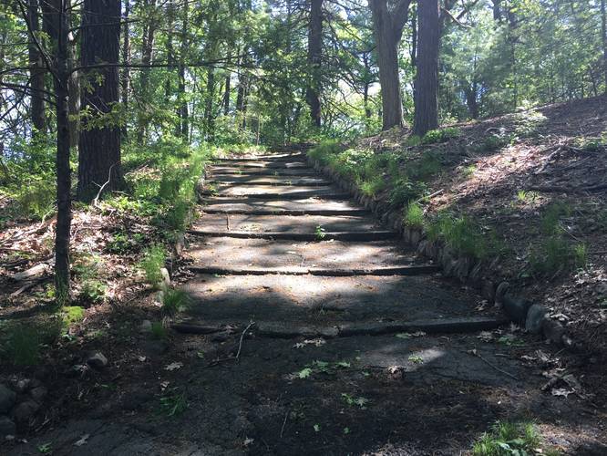
The trail is accessible from Woodbine St right off Commonwealth Avenue. The park is made up of just over 13 acres of woods and fields along the Charles River. There are several well maintained trails around the park including some older paved trails.

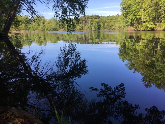
The park features beautiful views of the Charles River, woodland, fields and trails. There are several park benches around the place to sit. Trails are easily walked or biked!

Pets: This is a dog friendly park. Dogs must be leashed and their waste carried out.

Biking: Biking is allowed.
Explore 32 trails near Newton, MA
  1. Parking

    42.34743, -71.255868
  2. Main Trailhead

    42.34743, -71.255868
  3. Old Stairway through the woods

    42.347432, -71.256799
    Old Stairway through the woods
  4. Charles River

    42.349209, -71.258339
    Charles River
  5. Woodbine St Entrance

    42.347331, -71.255746
    Woodbine St Entrance
No community routes found. To add your own hike as a Community Route for this Trail guide, leave a Trip Report with an attached GPX file.

Hazards

Ticks - Lyme Disease More Info (CDC)

Seasons

All

Weather Forecast

In Newton, MA

Explore Hiking Trails

You May Also Like

Colorado's Million Dollar Highway - Plan a day's drive adventure along the iconic Million Dollar Highway in Colorado. Explore the best short trails, roadside stops, waterfalls, vistas, ghost towns, and hot springs within a ~6 hour road trip.
Explore

Colorado's Million Dollar Highway

Plan a day's drive adventure along the iconic Million Dollar Highway in Colorado. Explore the best short trails, roadside stops, waterfalls, vistas, ghost towns, and hot springs within a ~6 hour road trip.

Read
Glacier's Going-to-the-Sun Road - Discover the breathtaking beauty of Glacier National Park along the iconic Going-to-the-Sun Road. From stunning roadside stops to picturesque waterfalls and vistas, this engineering marvel offers endless opportunities for exploration.
Explore

Glacier's Going-to-the-Sun Road

Discover the breathtaking beauty of Glacier National Park along the iconic Going-to-the-Sun Road. From stunning roadside stops to picturesque waterfalls and vistas, this engineering marvel offers endless opportunities for exploration.

Read
New York's Best Waterfalls - Whether you're planning a day hike, roadside stop, or a leisurely short walk, this guide provides hikers, travelers, and locals alike with 63 different locations to over 100 scenic waterfalls to help plan your next adventure!
Explore

New York's Best Waterfalls

Whether you're planning a day hike, roadside stop, or a leisurely short walk, this guide provides hikers, travelers, and locals alike with 63 different locations to over 100 scenic waterfalls to help plan your next adventure!

Read

Before you boogie...

Find our trail guides useful? Consider becoming a Supporter to unlock perks!

MyHikes is an indie platform that makes exploring public trails easier for everyone. The platform has no investors, no ads, and is owned and operated by one person, Dave Miller. Dave has personally mapped and written over 1,800 trail guides on MyHikes for the public to explore. MyHikes has helped millions outdoor enthusiasts plan their next adventure.

But it takes a lot of time ๐Ÿ•ฆ, money ๐Ÿ’ฐ, work, and espresso shots โ˜• to run MyHikes, including hiking , mapping , writing , and publishing new trails with high-quality (accurate) information... along with software engineering (coding) the platform like building new features, website and mobile app development (iOS and Android), site maintainance . and much much more.

Supporters unlock website and mobile app perks with an annual one-time payment of $25 (you renew) ๐Ÿ˜Ž๐Ÿ‘. Or you can simply make a Donation of your choice. Otherwise, you can support us by telling your friends about MyHikes - both quick and free ๐ŸŽ‰

Admin user profile picture

Dave Miller
MyHikes Founder