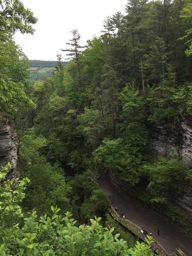
Loading...

WINTER SALE! 50% OFF Supporter Accounts — now through January 31st. Learn More.

North Rim Trail

The Indian Trail (aka North Rim Trail) at Watkins Glen State Park, New York, is a short 1 mile one-way trail that leads from the west end of the Watkins Glen Gorge Trail over to the suspension bridge and Point Lookout on the east end, which gives you a view of the gorge near the entrance to the park. You can use this trail mainly as a lower-trafficked connecting trail to head back east after completing the Watkins Glen Gorge Trail.

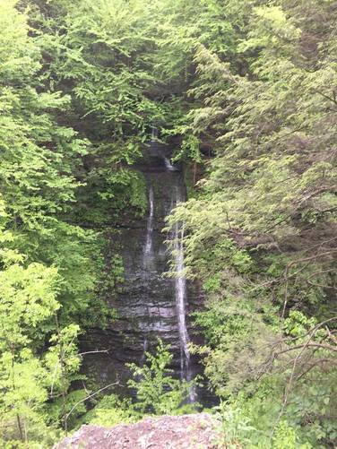
Along the route there are 2 lookout points - one gives you a view of Rainbow Falls and the other gives you a view of the Central Falls area.

if you parked in the south section of Watkins Glen, you can take the South Parking to Gorge Trail back to parking since the end of the Indian Trail connects with this small connecting trail.

Pets
Dogs are allowed on this trail, but you cannot bring them along the Watkins Glen Gorge Trail.

Biking
Biking is not allowed on this trail.

Parking
Hikers can park at the coordinates provided - located in the western side of the park. Hikers can also find parking at the southern entrance here: 42.372398, -76.874924 or at the eastern entrance here: 42.376313, -76.871369.
Explore 90 trails near Watkins Glen, NY

Know Before You Go

  • The Indian Trail is a 1-mile connecting trail in Watkins Glen State Park that offers less crowded access between the west and east ends of the gorge.
  • The trail features two lookout points with views of Rainbow Falls and Central Falls.
  • Dogs are permitted on the Indian Trail but not on the Watkins Glen Gorge Trail, and biking is prohibited.
Interactive topographic map for North Rim Trail located in Watkins Glen, NY. Click the "View Map" button to load GPS coordinates and trail markers.
Get directions
Distance
1.0 mi
Difficulty
Easy
Type
One-Way
Est. Time
30 min
Elev. Gain
12'
Rating
0.0
Added
May 27, 2017
Updated
January 15, 2026

Weather Forecast

Loading...
Total Change
303'
Ascent
12'
Descent
315'
Loading...

Download the GPX Data for Offline Use

Supporters get exclusive access to download trail routes to the MyHikes app for offline use. Stay prepared on your adventure, even without an internet connection! Become a Supporter today to unlock this feature and hike with confidence.

Download North Rim Trail GPX Data to the MyHikes Mobile App

Features

Vista / Lookout Point
Dogs
Waterfalls

Points of interest

  1. Parking

    42.374144, -76.892191
  2. Main Trailhead

    42.371742, -76.891674

Safety information

For your own safety: plan ahead, let someone know where you'll be, and hike at your own risk.

Availability

Spring

Surface type

Dirt

Trip Reports (Reviews)

Your opinion matters! Be the first to rate this trail.

Ready to help fellow hikers? Add a trip report to share your experience and provide valuable insights for other hikers!

1.0 mile / 1.6 km
August 04, 2024
Hiked back to the Gorge Trail after hiking up from the lower parking lot. Waterfalls in the gorge were beautiful but the lookout point along this trail was completely covered by the summer-time vegetation.
Hiking
1.0 mile / 1.6 km
October 05, 2019
Easy hike back from hiking up the Watkins Glen Gorge Trail. Also note that the park still has signage for the 'Indian Trail', but on their park map, this trail is called the North Rim Trail. It's difficult to say whether or not the park renamed the trail and just didn't change the trailhead signs out on the trail.
Hiking
1.0 mile / 1.6 km
May 26, 2017
Hiking
No community routes found. To add your own hike as a Community Route for this Trail guide, leave a Trip Report with an attached GPX file.

Popular categories

Scenic mountain view representing vista trails
Vista trails
Scenic gorge of cascades representing waterfall trails
Waterfall hikes
Rugged mountain terrain representing summit trails
Summit trails
Scenic mountain view representing dog-friendly trails
Dog-friendly
Scenic campsite with a view representing camping trails
Camping trails
Appalachian Trail logo representing A.T. hikes
A.T. hikes

You May Also Like

Colorado's Million Dollar Highway - Plan a day's drive adventure along the iconic Million Dollar Highway in Colorado. Explore the best short trails, roadside stops, waterfalls, vistas, ghost towns, and hot springs within a ~6 hour road trip.
Explore

Colorado's Million Dollar Highway

Plan a day's drive adventure along the iconic Million Dollar Highway in Colorado. Explore the best short trails, roadside stops, waterfalls, vistas, ghost towns, and hot springs within a ~6 hour road trip.

Read
Glacier's Going-to-the-Sun Road - Discover the breathtaking beauty of Glacier National Park along the iconic Going-to-the-Sun Road. From stunning roadside stops to picturesque waterfalls and vistas, this engineering marvel offers endless opportunities for exploration.
Explore

Glacier's Going-to-the-Sun Road

Discover the breathtaking beauty of Glacier National Park along the iconic Going-to-the-Sun Road. From stunning roadside stops to picturesque waterfalls and vistas, this engineering marvel offers endless opportunities for exploration.

Read
🍪 We use cookies to learn about site usage and to serve map tiles. You may block cookies manually in the browser. By continuing you agree. Learn more