Loading...

Distance:
2.4 Miles / 3.9 km
Type:
Out-and-Back
Difficulty:
Easy
Time to Hike:
1 hour, ~12 minutes
Features:
Surface Type:
Dirt
Park:
North Park
Town:
McCandless, Pennsylvania
Directions:
40.591825, -79.999032
Added:
November 05, 2017
Updated:
June 06, 2018

The Purple Blaze Trail at North Park in McCandless, Pennsylvania is an easy 2.4 mile out-and-back hike in the central-to-southern section of the park. This has two trailheads - one on Old Ingomar Rd and one on East Ingomar Rd - this GPS data brings you from Old Ingormar Rd west to East Ingormar and back; however, you can hike this whichever way you want.

The trail itself is mainly flat with a few ascents and descents along the way, but nothing difficult. In autumn, this is a great trail to see what Pennsylvania's foliage has to offer since you can often see the colorful surrounding hills through the breaks in the trees.

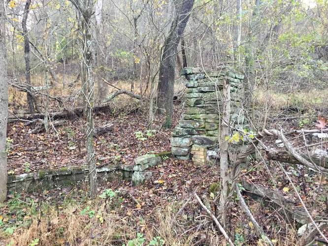
One unique part of this trail is that at the trailhead off of Old Ingomar Rd, there's an old fireplace and chimney sitting on what looks like an old foundation.

Note: at the end of this trail on the western side is a the Purple & Black Dot Trail - this trail appears to be closed and it looks like the park has started to strip the blazes off some of the trees. So you cannot make a loop of the Purple + Purple/Black Dot Trails anymore.

Explore 222 trails near McCandless, PA
  1. Parking

    40.591825, -79.999032
  2. Main Trailhead

    40.590906, -79.998816
  3. Old homestead/fireplace

    40.590911, -79.998756
    Old homestead/fireplace
Explore other trail routes for this hike, added by the MyHikes Community via Trip Reports.
No community routes found. To add your own route as a Community Route for this Trail guide, please leave a Trip Report with a GPX file on this Trail.

Hazards

Ticks - Lyme Disease More Info (CDC)

Seasons

All

Blaze Color

Purple
Loading...
Loading...
182 '

Total Change
405 '

Ascent
270 '

Descent

Photo Albums

1 Trip Report

No Star-Ratings
Write-up by:
Admin user profile picture
2.4 miles / 3.9 km
Trail added
November 05, 2017
Hiked on
November 05, 2017
Updated on
June 06, 2018

Weather Forecast

In McCandless, PA

Explore Hiking Trails

New Hikes

Sugar Hill Fire Tower Hike
0.7 Miles
1.1 km
Easy
Out-and-Back
Congaree Boardwalk Loop
2.5 Miles
4 km
Easy
Loop
Almond Lake Overlook
0.1 Miles
0.2 km
Easy
Out-and-Back
Spencer Pond Loop
0.3 Miles
0.5 km
Easy
Loop

Before you leave...

MyHikes is an indie web platform aimed to make exploring public trails easier for everyone. The site has no investors and is owned and operated by one person, Dave Miller (Founder & Admin). As the Founder, main contributor, and doer-of-all-things for MyHikes, I share my trips with over-detailed write-ups for fun on a volunteer basis and I believe that public trail information should be available to everyone.

It takes a lot of time 🕦, money 💰, and effort (including espresso shots ☕) to run MyHikes, including hiking , mapping , writing , and publishing new trails with high-quality content... along with building new features, moderating, site maintainance, and app development for iOS and Android . I simply ask that if you find MyHikes' trail guides helpful to please consider becoming a Supporter to help keep the site, iOS, and Android apps available to everyone.

Supporters unlock website and in-app perks with a one-time payment of $25 (you renew) 😎👍. Or you can simply make a Donation of your choice without a MyHikes user account. Otherwise, telling your friends about MyHikes is the next-best thing - both quick and free 🎉

Thanks for visiting MyHikes and have a great hike!️

Admin user profile picture

Dave Miller
MyHikes Founder & Admin