There seems to be a lot of mountains named North Mountain in Virginia, along with Brushy Mountains and Cove Mountains. This is an out-and-back hike following the ridgeline of the North Mountain that forms the boundary between Rockbridge and Alleghany Counties in Virginia.
This hike contains an abundance of overlooks, many of which look east toward Big House and Little House Mountains, the town of Lexington, and the Blue Ridge Mountains near Buena Vista, Virginia. Lexington is the home of VMI and Washington and Lee University. W&L’s Outing Club published a guidebook some years ago which proclaimed of the North Mountain Trail, “Undoubtedly, this is Rockbridge County’s finest trail!” Anyone who has hiked it would be hard pressed to argue.
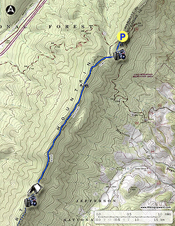
It is possible to start hiking the North Mountain Trail from its western end at the George Washington National Forest’s Longdale Recreation Area, but most folks drive up to the ridge line using Route 770, start from the east, and only hike the best part of the trail. That is the hike described here.
A couple of caveats: This is a well-known mountain biking trail. Be sure to keep an eye out for riders on this trail on weekends. And the description includes a location known locally as “Pete’s Cave.” We did not explore this, we do not know whether it legitimately qualifies as a “cave.” and by mentioning it we do not imply that you should explore it either. There may not even be a cave. But it is best to be safe out there!
Parking: At the ridge on VA 770 you will see a small parking area. Park here, and look for the trail to start in one of two places across and a little down the east slope of the mountain. There are no trail signs here.
-
Mile 0.0 – The two trails coming off of Collierstown Road merge within 50 feet, so it does not matter which choice you make. Pass a post that appears to have once held a trail sign, and follow a rocky trail among rhododendron and Virginia Pine. Almost immediately, the blue blazed North Mountain Trail is fenced in on the left by a rock face.
-
Mile 0.2 – Do not plan to race along this trail at the start of this hike, because there are serious fireworks right away. The rock face on your left can be climbed in several places to reveal spectacular views, especially near sunrise. These overlooks become progressively easier to access from the trail as you continue down the trail. The first overlook requires about a 30 foot climb. The second overlook, about 300 feet further, requires about a 15 foot climb.
-
Mile 0.3 – Viewpoint three and 160 feet further, viewpoint four, just after that, do not require a climb.
-
Mile 0.4 – Viewpoint five is your last chance for an unobstructed view for a while. After this, the trail enters a long stretch of woods.
-
Mile 0.5 – Intersection with a woods road that heads down to the road you used to climb North Mountain. There is a trail sign here.
-
Mile 1.3 – The trail cuts through a rock line and continues on the other side of the rocks.
-
Mile 3.2 – The trail continues through the woods for another couple of miles, generally following the eastern edge of the ridge, with occasional views back towards Big and Little House Mountains. At 3.2 miles is the first and only fire ring, indicating an established campsite. The sixth eastern viewpoint is also found here. Contemplate whether these views could ever get old, but avoid staying here too long, as the highlight of the hike is just ahead.
-
Mile 3.4– Come to a nice series of stone steps that leads into a series of large rocks after a short, steep climb. Soon, you are completely surrounded by large rock formations. There seems to be caves and tunnels all around! Climb to the top or continue on the trail (which is actually difficult to locate in this wonderland), and you will have your only views to the west. Looking west, in the foreground you will see Interstate 64, Brushy and Mill Mountains – which form the Rich Hole Wilderness. Further west, using binoculars, ridgetop houses can be seen looking down from near the Homestead Resort. All the way to your right is the ridge taking the North Mountain Trail back to your vehicle.
Most folks will head back to their rides from here, though the North Mountain Trail continues all the way down to Longdale Furnace Recreation Area, administered by the National Forest. There are no more views on the trail, however if you continue on another 1.1 miles, staying straight where a trail sign says that Longdale Furnace is to the right, you will come to a large flat area with a wildlife pond that appears to be a good campsite. A woods road goes down to the valley from this spot. -
Mile 6.8 – Return to the parking area at the 6.8 mile mark, assuming you did not continue past the last viewpoint. On the way back, enjoy the eastern facing views all over again!