Loading...

๐Ÿ”ฅ End of Summer sale! 50% off on Supporter Accounts โ€” now through September 1st. Learn More.

North Fork Mountain Hike

Directions
Map
Pictures
Send to App
Distance:
23.0 Miles / 37.0 km
Type:
One-Way
Difficulty:
Hard
Time to Hike:
11 hours, ~30 minutes
Features:
Surface Type:
Dirt
Park:
Monongahela National Forest
Town:
Franklin, West Virginia
Directions:
38.711516, -79.402846
Added:
March 18, 2025
Updated:
April 05, 2025
Guide by:
Copy Trail Link Hiking this trail? Send a friend or family member a link to this trail guide for your own safety. Hike at your own risk (disclaimer)
Loading...
Loading...
2,673'

Total Change
2,862'

Ascent
5,324'

Descent

Download the Trail Route for Offline Use

Supporters get exclusive access to download trail routes to the MyHikes app for offline use. Stay prepared on your adventure, even without an internet connection! Become a Supporter today to unlock this feature and hike with confidence.

Send to App

North Fork Mountain Hike

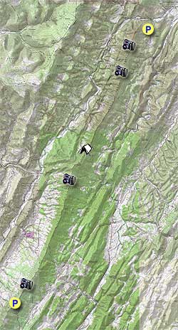
Hikers describe the North Fork Mountain Trail (NFMT) as having "relentless views". They are correct, there are so many overlooks we couldn't mark them all on our hike map. If you want a view, walk no more than 25 yards to the west off the trail and you will find one! We were amazed by this trail and the different types of woodlands, many of them needing fires in order to grow, see this link from The Nature Conservancy for more information.

The lack of water on this trail has always been a concern for hikers. However, a post by Zach F. on the WV Highlands Conservancy site proved very useful in finding a spring at the trail midpoint. If you hike this trail, please post a review with an update on how much water is in the spring. This will help fellow hikers track how reliable the spring is over time.

The NFMT at 24.7 miles long, is a point to point shuttle backpack best hiked South to North. At the bottom of this write up we also list several shorter alternatives if you don't have time to do the whole trail. Plan to allow about 35 minutes each way for the car shuttle.

  • Mile 0.0 โ€“ At the South Trail Head, walk around the gate towards the back of the radio building and tower. To your left you will see a discernible trail, this is the North Fork Mountain (Trail 501) and you will very quickly see blue blazes. Eventually there will be blue diamond markers on the trees for the majority of the trail. There is a short climb to the top of the trail.
  • Mile 0.5 โ€“ Reach the first of many overlooks on your left and to the west. The majority of views on the hike will be to the west.
  • Mile 1.0 โ€“ Overlook, the next 2 miles are a gentle walk in the woods.
  • Mile 3.2 โ€“ Overlook, unique campsite just after this overlook and before the power lines.
  • Mile 3.4 โ€“ Power lines, views to the east and west.
  • Mile 3.8 โ€“ Gate, go around and continue on fire road/trail
  • Mile 4.5 โ€“ Intersection with unnamed trail/fire road
  • Mile 4.6 โ€“ Overlook
  • Mile 5.7 โ€“ Overlook
  • Mile 8.4 โ€“ Spur Trail to see Seneca Rocks. Don't miss this, it's a great view of the backside of Seneca Rocks off in the distance.
  • Mile 8.7 โ€“ Overlook
  • Mile 10.4 โ€“ Flat Tower on left and beginning of FR79, bear to right on fire road. From here to the first nights campsite at mile 12.4 was the least enjoyable part of the hike due to it being on a fire road.
  • Mile 10.8 โ€“ Radio Tower, road bears to the left behind tower. Reach first curve on FR79, but continue down road past pipeline crossing.
  • Mile 11.6 โ€“ Gas pipeline crossing
  • Mile 12.4 โ€“ Campsite for night one. To right of campsite is a grass fire road, go about 100 steps downhill, look for square stone, go left about 30 steps to spring. Spring water amount note: 1. May 10, 2014 โ€“ 12โ€, 2. Summer 2013 โ€“ flowing. Be prepared to carry enough water in the event the Spring is dry. You could also cache water near this intersection.
  • Day 2 - Hike begins at the brown "Trail 501" sign. There is evidence of fire from the campsite along the next 2 miles of the trail.
  • Mile 12.9 โ€“ Overlook, great view to start Day 2. Fire damage
  • Mile 15.4 โ€“ Overlook, trail is well maintained
  • Mile 16.5 โ€“ Intersection of Redman Run Trail, just after the intersection is a campsite with an incredible view. As you climb you will soon walk through a Rhododendron thicket, look for cairns on the left for the overlook at mile 18.
  • Mile 18.0 โ€“ Overlook
  • Mile 18.4 โ€“ Campsite
  • Mile 18.5 โ€“ Overlook
  • Mile 19.5 โ€“ Overlook
  • Mile 20.6 โ€“ Intersection of Landis Trail
  • Mile 21.0 โ€“ Overlook, Table Rock Vista
  • Mile 21.6 โ€“ Spur trail to Chimney Top, stay straight for this out and back. The NFMT turns sharply to the right but go straight on the unmarked spur trail, you can see Chimney Top from here.
  • Mile 21.8 โ€“ Chimney Top, great views. There is another way back to the NFMT, a very steep spur trail to the right of a fire ring. This is very steep, so use caution descending.
  • Mile 22.0 โ€“ Original Intersection, bear left back onto the NFMT
  • Mile 22.2 โ€“ Intersection of steep spur trail to Chimney Top on left.
  • Mile 22.6 โ€“ Overlook
  • Mile 22.9 โ€“ Overlook
  • Mile 24.7 โ€“ North Trail Head Parking, end of hike.

Shorter Alternative Hikes:

  1. Redman Run Trail up to NFMT and over to North Trail Head parking, 9.6 miles, shuttle hike.
  2. Landis Trail Head up to NFMT and over to North Trail Head parking, 5.4 miles, shuttle hike or you could do as an out and back to Chimney Top.
  3. North Trail Head parking up to Chimney top and back, about 7 miles round trip.
  4. Fire Road 79, drive car to campsite as mentioned at mile 12.4, sketchy road, good clearance needed on this road, camp the night and do the remaining 12 or so miles on Day 2, shuttle hike.
Explore 68 trails near Franklin, WV
  1. Parking

    38.711516, -79.402846
  2. Main Trailhead

    38.711516, -79.402846
No community routes found. To add your own hike as a Community Route for this Trail guide, leave a Trip Report with an attached GPX file.

Hazards

Ticks - Lyme Disease More Info (CDC)
Snakes
Poison Ivy/Oak

Seasons

All

Blaze Color

Blue

Trip Reports (Reviews)

Rated 4.45 out of 5 based on 22 ratings.
By: Jared H
23.0 miles / 37.0 km
November 01, 2019
Beautiful to hike in the late fall, views are unimpeded by leaves up top on the ridge, but still tons of color to be seen. Cliffs are incredible. Campsite at 16.5 was incredible, thanks for marking that out in your write-up. About the SPRING -- talked to a local climber/backpacker who lives in Franklin WV. He said the spring had only ever been dry to his knowledge in 2007, when they had a 50-year drought. According to him, it is very reliable. How to find the spring: It's very easy to find. The center section of the NFMT uses Public Road 79, a gravel road. If you're coming from the south, you walk from the radio tower up high on the ridge about a mile and half (mostly downhill) on PR79 . When you come to the point when 79 switches back hard down the east side of the ridge, the NFMT will continue straight along the ridge as a normal hiking trail again, which is clearly marked. It's at that point you'll be able to see a faint grassy road or path heading WEST downhill. Go about 100ft downhill, then look for a short path off to the left (marked by a cairn), which goes about 30ft to the spring. If you're coming from the North side, just make note as soon as you hit the gravel road, then find the grass road on your right leading to the spring. GPS coordinates of the spring: 38ยฐ51'33"N 79ยฐ18'50"W Google map link: https://www.google.com/maps/place/38ยฐ51'33.0"N+79ยฐ18'50.0"W/@38.8591709,-79.3160829,17z
Legacy Review
By: Jim Bob
23.0 miles / 37.0 km
September 27, 2019
Great hike. Amazing views. Practically a state wide drought and water was available at spring. If your looking for a shuttle ask around at some of the area businesses.
Legacy Review
By: SR
23.0 miles / 37.0 km
September 02, 2019
Did this trail south to north over two nights on Labor Day Weekend. We tracked 8.4 miles the first day to camp, 11.7 miles the second day to the nice overlook camping at Redman Run junction, 9.7 miles the third day = closer to 30 miles. So beware that you may also track more miles than promised! Lots of variation, both of flora and elevation, more than you may expect from a "ridge" hike. This trail has a bit of everything, and some of the most exceptional views in the east! The only thing missing is water. We carried 5-6 litres a person and the spring at the end of the road section was easy to find and deep enough to filter easily.
Legacy Review

Weather Forecast

In Franklin, WV

Explore Hiking Trails

You May Also Like

Colorado's Million Dollar Highway - Plan a day's drive adventure along the iconic Million Dollar Highway in Colorado. Explore the best short trails, roadside stops, waterfalls, vistas, ghost towns, and hot springs within a ~6 hour road trip.
Explore

Colorado's Million Dollar Highway

Plan a day's drive adventure along the iconic Million Dollar Highway in Colorado. Explore the best short trails, roadside stops, waterfalls, vistas, ghost towns, and hot springs within a ~6 hour road trip.

Read
New York's Best Waterfalls - Whether you're planning a day hike, roadside stop, or a leisurely short walk, this guide provides hikers, travelers, and locals alike with 63 different locations to over 100 scenic waterfalls to help plan your next adventure!
Explore

New York's Best Waterfalls

Whether you're planning a day hike, roadside stop, or a leisurely short walk, this guide provides hikers, travelers, and locals alike with 63 different locations to over 100 scenic waterfalls to help plan your next adventure!

Read

Before you boogie...

Find our trail guides useful? Consider becoming a Supporter to unlock perks!

MyHikes is an indie platform that makes exploring public trails easier for everyone. The platform has no investors, no ads, and is owned and operated by one person, Dave Miller. Dave has personally mapped and written over 1,800 trail guides on MyHikes for the public to explore. MyHikes has helped millions outdoor enthusiasts plan their next adventure.

But it takes a lot of time ๐Ÿ•ฆ, money ๐Ÿ’ฐ, work, and espresso shots โ˜• to run MyHikes, including hiking , mapping , writing , and publishing new trails with high-quality (accurate) information... along with software engineering (coding) the platform like building new features, website and mobile app development (iOS and Android), site maintainance . and much much more.

Supporters unlock website and mobile app perks with an annual one-time payment of $25 (you renew) ๐Ÿ˜Ž๐Ÿ‘. Or you can simply make a Donation of your choice. Otherwise, you can support us by telling your friends about MyHikes - both quick and free ๐ŸŽ‰

Admin user profile picture

Dave Miller
MyHikes Founder