Loading...

❄️ WINTER SALE! 50% OFF on Supporter Accounts — now through January 31st. Unlock a full year of exclusive website & app perks. Learn More.

Nooksack Falls Trail

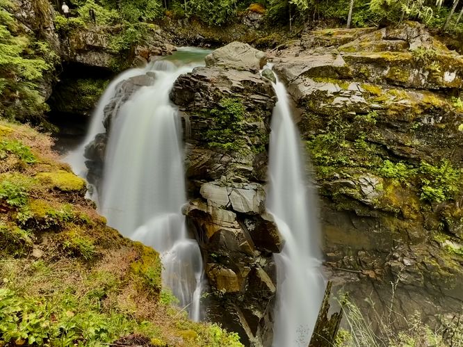
The Nooksack Falls Trail at Mt. Baker National Forest near Glacier, Washington is an easy 0.1-mile out-and-back walk that leads to the 88-foot tall waterfall, Nooksack Falls.

Explore Nooksack Falls

This very short trail begins along the south side of Wells Creek Road near Glacier, Washington and leads downhill to reach a viewpoint of the scenic 88-foot tall Nooksack Falls. At the end of the trail, you'll find a fence line that surround super-steep cliffs, which exist for your own safety. Always stay on the safe side of the fence for your own protection as several people have accidentally died here as they went "too far" onto unstable terrain on these cliffs. From the edge of the fence, you'll find a view of the upper half of Nooksack Falls as it plummets over an 88-foot tall cliff in the North Fork Nooksack River. No matter where you stand at the lookout, you will not be able to view the entire cascade without using an extendable cellphone stick, but regardless the sheer power of the waterfall is a sight to behold and well worth a visit. When you're done exploring the waterfall, the walk back to parking is easy. Before you leave, you might want to take a short walk under the Wells Creek Road bridge to get an upstream view of the North Fork Nooksack River as it provides additional scenery.

Parking

Visitors will find a large parking turnout at the coordinates provided, located on the north side of Wells Creek Road near Glacier, Washington. The turnout is large enough to fit a couple dozen vehicles as of June 2025.

Pets

Dogs are allowed only if leashed and must be cleaned up after.

Warning

Cliffs: This trail leads out to cliffs with sheer drop-offs. Always stay on-trail at all times and do not cross the fence line for your own safety. People have died here by accident while attempting to get a better view of the waterfall. The best view is from the trail, despite maybe not being able to see the entirety of the cascade's full height.

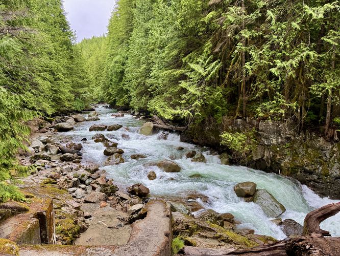
Strong currents: Note that while the scenery of the Nooksack River, above Nooksack Falls, may be pretty, it can also be deadly. Stay out of the river upstream of the waterfall to ensure your own safety. One false move upstream would ultimately send you down and over the 88-foot tall waterfall, likely to your death.
Explore 6 trails near Glacier, WA

Know Before You Go

  • The Nooksack Falls Trail is a very short (0.1 mile) and easy walk to a viewpoint of the 88-foot Nooksack Falls.
  • Safety is paramount due to steep cliffs and strong currents; stay on the trail, behind the fence, and out of the river upstream of the falls.
  • A large parking area is available, and dogs are allowed on leash.
Interactive topographic map for Nooksack Falls Trail located in Glacier, WA. Click the "View Map" button to load GPS coordinates and trail markers.
Get directions
Distance
0.1 mi
Difficulty
Easy
Type
Out-and-Back
Est. Time
5 min
Elev. Gain
35'
Rating
4.0
Added
June 21, 2025
Updated
July 16, 2025

Weather Forecast

Loading...
Total Change
35'
Ascent
35'
Descent
35'
Loading...

Download the GPX Data for Offline Use

Supporters get exclusive access to download trail routes to the MyHikes app for offline use. Stay prepared on your adventure, even without an internet connection! Become a Supporter today to unlock this feature and hike with confidence.

Download Nooksack Falls Trail GPX Data to the MyHikes Mobile App

Features

Vista / Lookout Point
Dogs
Waterfalls

Points of interest

  1. Parking

    48.905777, -121.808838
  2. Main Trailhead

    48.905664, -121.808865

Safety information

For your own safety: plan ahead, let someone know where you'll be, and hike at your own risk.

Hazards

Poison Ivy or Poison Oak
Rockfalls, Ledges, or Scrambles

Availability

All seasons

Surface type

Dirt

Trip Reports (Reviews)

Rated 4.0 out of 5 based on 1 rating.

Ready to help fellow hikers? Add a trip report to share your experience and provide valuable insights for other hikers!

0.1 miles / 0.2 km
June 20, 2025
Hiking
No community routes found. To add your own hike as a Community Route for this Trail guide, leave a Trip Report with an attached GPX file.

Popular categories

Scenic mountain view representing vista trails
Vista trails
Scenic gorge of cascades representing waterfall trails
Waterfall hikes
Rugged mountain terrain representing summit trails
Summit trails
Scenic mountain view representing dog-friendly trails
Dog-friendly
Scenic campsite with a view representing camping trails
Camping trails
Appalachian Trail logo representing A.T. hikes
A.T. hikes

You May Also Like

Glacier's Going-to-the-Sun Road - Discover the breathtaking beauty of Glacier National Park along the iconic Going-to-the-Sun Road. From stunning roadside stops to picturesque waterfalls and vistas, this engineering marvel offers endless opportunities for exploration.
Explore

Glacier's Going-to-the-Sun Road

Discover the breathtaking beauty of Glacier National Park along the iconic Going-to-the-Sun Road. From stunning roadside stops to picturesque waterfalls and vistas, this engineering marvel offers endless opportunities for exploration.

Read
Colorado's Million Dollar Highway - Plan a day's drive adventure along the iconic Million Dollar Highway in Colorado. Explore the best short trails, roadside stops, waterfalls, vistas, ghost towns, and hot springs within a ~6 hour road trip.
Explore

Colorado's Million Dollar Highway

Plan a day's drive adventure along the iconic Million Dollar Highway in Colorado. Explore the best short trails, roadside stops, waterfalls, vistas, ghost towns, and hot springs within a ~6 hour road trip.

Read
🍪 We use cookies to learn about site usage and to serve map tiles. You may block cookies manually in the browser. By continuing you agree. Learn more