Loading...

Distance:
0.1 Miles / 0.2 km
Type:
Out-and-Back
Difficulty:
Easy
Time to Hike:
~5 minutes
Features:
Surface Type:
Dirt
Park:
Pu'u ka Pele Forest Reserve
Town:
Waimea, Hawaii
Directions:
22.005098, -159.678242
Added:
June 28, 2022
Updated:
July 06, 2022
Please consider making a donation to the Maui Strong Fund to help the victims of Hawaii's recent wildfires.
Loading...
Loading...
8 '

Total Change
11 '

Ascent
11 '

Descent

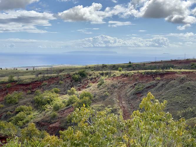
The Ni'ihau & Lehua Crater Vista at Pu'u ka Pele Forest Reserve in Waimea, Hawaii (Kauai) is an easy roadside walk to a view of the island of Ni'ihau and Lehua Crater.

This is not a hike and barely a walk - simply just a few steps from your car out to a nice vista point. Total mileage is less than 0.1-miles and is negligible. The island of Ni'ihau is located on the horizon on the left-hand side while the Lehua Crater is on the right-side on the horizon.

Parking
Visitors will find parking near the coordinates provided at a small parking turnout. The turnout is large enough to fit a few vehicles.

Respecting the Land
Hawaiian land is considered sacred to native Hawaiians and many locals, so please stay on-trail, take nothing but photos, and leave nothing but footprints. Respect the locals - don't stay for long and have a backup hike planned in case the parking lot is full.

Explore 51 trails near Waimea, HI
  1. Parking

    22.005098, -159.678242
  2. Main Trailhead

    22.005143, -159.678313
  3. View of the island of Ni'ihau (left) and Lehua Crater (right) on the horizon

    22.005061, -159.678453
    View of the island of Ni'ihau (left) and Lehua Crater (right) on the horizon
No community routes found. To add your own hike as a Community Route for this Trail guide, leave a Trip Report with an attached GPX file.

Seasons

All

Photo Albums

2 Trip Reports

No Star-Ratings
Write-up by:
Admin user profile picture
0.1 miles / 0.2 km
Trail added
June 28, 2022
Hiked on
June 25, 2022
Updated on
July 06, 2022
0.1 miles / 0.2 km
June 25, 2022
Hiking

Weather Forecast

In Waimea, HI

Explore Hiking Trails

New Hikes

Bates Ferry Trail and General Greene Tree
2.7 Miles
4.3 km
Easy
Out-and-Back
Mt. Morris Dam Overlook
3.3 Miles
5.3 km
Easy
Out-and-Back
Angel Falls Loop
2.8 Miles
4.5 km
Moderate
Loop
Weston Lake Loop
3.2 Miles
5.1 km
Easy
Loop

Before you leave...

MyHikes is an indie web platform aimed to make exploring public trails easier for everyone. The site has no investors and is owned and operated by one person, Dave Miller (Founder & Admin). As the Founder, main contributor, and doer-of-all-things for MyHikes, I share my trips with over-detailed write-ups for fun on a volunteer basis and I believe that public trail information should be available to everyone.

It takes a lot of time 🕦, money 💰, and effort (including espresso shots ☕) to run MyHikes, including hiking , mapping , writing , and publishing new trails with high-quality content... along with building new features, moderating, site maintainance, and app development for iOS and Android . I simply ask that if you find MyHikes' trail guides helpful to please consider becoming a Supporter to help keep the site, iOS, and Android apps available to everyone.

Supporters unlock website and in-app perks with a one-time payment of $25 (you renew) 😎👍. Or you can simply make a Donation of your choice without a MyHikes user account. Otherwise, telling your friends about MyHikes is the next-best thing - both quick and free 🎉

Thanks for visiting MyHikes and have a great hike!️

Admin user profile picture

Dave Miller
MyHikes Founder & Admin