The Nichols Arboretum Hike at Nichols Arboretum in Ann Arbor, Michigan is a moderate 1.4-mile out-and-back walk that features a view at the Main Valley Overlook, a walk through the peony garden, and a stops at the Fairy Woods & Troll Hollow.
Hike Description
This hike begins at the entrance along Geddes Ave and follows the main path downhill for a short while before taking a quick detour through a smaller trail that leads down to the Main Valley Overlook.
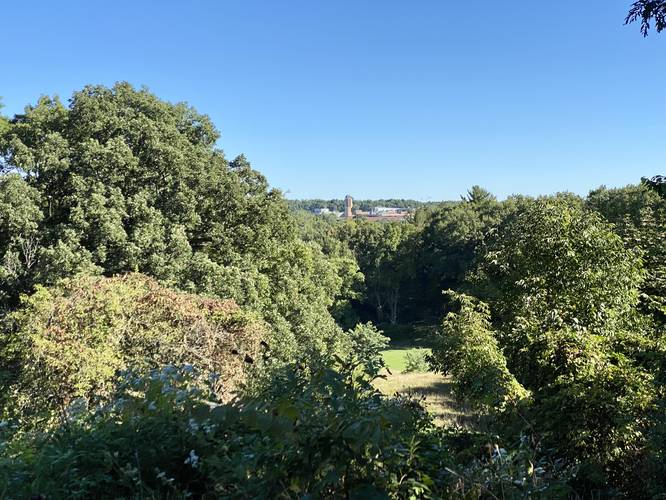
Main Valley Overlook - Mile 0.15
At mile 0.15, hikers will reach the Main Valley Overlook, also known as the Deborah Gimbel Memorial Overlook. Views here face north, overlooking the park.
Left-Hand Turn - Mile 0.44
After passing the overlook, hikers will continue hiking down the main path until they reach a junction around mile 0.44. Note the post with the trail map, as of September 2022, as a POI for locating this junction. After taking a left-hand turn, hikers will pass through a hemlock grove where the forest floor is wide open, making for a different ecosystem than what's found just up the hill.
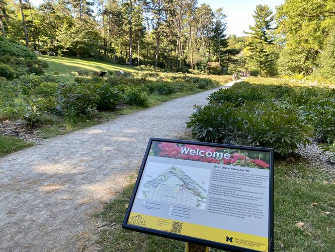
Peony Garden - Mile 0.6 to 0.65
At mile 0.53, hikers will take a left-hand turn to walk up a series of stairs that leads to the Peony Garden. At mile 0.6 is the start of the Peony Garden - one of the main attractions to the Arb. Peonies generally bloom during late Spring and through the Summer, so on this hike during late September, none were in-bloom which was not surprising.
Washington Heights Trailhead - Mile 0.7
At mile 0.7, hikers will reach the trailhead along Washington Heights Rd. On this hike, we turned around here and followed the trail north of the Peony Garden, around the bend, and back to reach the Fairy Woods & Troll Hollow.
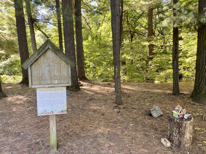
Fairy Woods & Troll Hollow - Mile 0.92
Along this recording, around mile 0.92, hikers will reach the Fairy Woods & Troll Hollow - a location where fairies and trolls have built tiny homes, or at least, have had help from human friends. No fairies or trolls were spotted on this hike.
Hiking Out
After passing through Troll Hollow, this recording heads back to the main path that lead down to the Peony Garden and follows the trail back uphill to the Geddes Ave trailhead.
Parking
Note that there's no parking along Geddes Ave and the parking marker will bring hikers to Oswego Street where free short-term parking is available without a permit. Hikers will find more street parking along neighboring streets to the Geddes Ave trailhead - park at your own risk and read the signs accordingly. With regard to parking along Washington Heights - there are 5 reserved Nichols Arb parking spots along that road; however, they require a parking permit which apparently can be picked up from the University of Michigan; however, the details on how to do this on their website were extremely confusing, so we opted to park near the Geddes Ave trailhead instead.
Pets
Dogs are allowed if leashed and their waste should be carried out by the hiker.
Prohibited
Biking and hammocking are prohibited in the Arb.
Hike Description
This hike begins at the entrance along Geddes Ave and follows the main path downhill for a short while before taking a quick detour through a smaller trail that leads down to the Main Valley Overlook.
Main Valley Overlook - Mile 0.15
At mile 0.15, hikers will reach the Main Valley Overlook, also known as the Deborah Gimbel Memorial Overlook. Views here face north, overlooking the park.
Left-Hand Turn - Mile 0.44
After passing the overlook, hikers will continue hiking down the main path until they reach a junction around mile 0.44. Note the post with the trail map, as of September 2022, as a POI for locating this junction. After taking a left-hand turn, hikers will pass through a hemlock grove where the forest floor is wide open, making for a different ecosystem than what's found just up the hill.
Peony Garden - Mile 0.6 to 0.65
At mile 0.53, hikers will take a left-hand turn to walk up a series of stairs that leads to the Peony Garden. At mile 0.6 is the start of the Peony Garden - one of the main attractions to the Arb. Peonies generally bloom during late Spring and through the Summer, so on this hike during late September, none were in-bloom which was not surprising.
Washington Heights Trailhead - Mile 0.7
At mile 0.7, hikers will reach the trailhead along Washington Heights Rd. On this hike, we turned around here and followed the trail north of the Peony Garden, around the bend, and back to reach the Fairy Woods & Troll Hollow.
Fairy Woods & Troll Hollow - Mile 0.92
Along this recording, around mile 0.92, hikers will reach the Fairy Woods & Troll Hollow - a location where fairies and trolls have built tiny homes, or at least, have had help from human friends. No fairies or trolls were spotted on this hike.
Hiking Out
After passing through Troll Hollow, this recording heads back to the main path that lead down to the Peony Garden and follows the trail back uphill to the Geddes Ave trailhead.
Parking
Note that there's no parking along Geddes Ave and the parking marker will bring hikers to Oswego Street where free short-term parking is available without a permit. Hikers will find more street parking along neighboring streets to the Geddes Ave trailhead - park at your own risk and read the signs accordingly. With regard to parking along Washington Heights - there are 5 reserved Nichols Arb parking spots along that road; however, they require a parking permit which apparently can be picked up from the University of Michigan; however, the details on how to do this on their website were extremely confusing, so we opted to park near the Geddes Ave trailhead instead.
Pets
Dogs are allowed if leashed and their waste should be carried out by the hiker.
Prohibited
Biking and hammocking are prohibited in the Arb.