Loading...

Newhalem Waterfall Lookout

Directions
Map
Pictures
Send to App
Distance:
0 Miles / 0 km
Type:
Out-and-Back
Difficulty:
Easy
Time to Hike:
~5 minutes
Features:
Surface Type:
Universal Access
Park:
North Cascades National Park
Town:
Newhalem, Washington
Directions:
48.68765, -121.234771
Added:
June 19, 2025
Updated:
July 08, 2025
Copy Trail Link Hiking this trail? Send a friend or family member a link to this trail guide for your own safety. Hike at your own risk (disclaimer)
Loading...

Download the Trail Route for Offline Use

Supporters get exclusive access to download trail routes to the MyHikes app for offline use. Stay prepared on your adventure, even without an internet connection! Become a Supporter today to unlock this feature and hike with confidence.

Send to App

Newhalem Waterfall Lookout

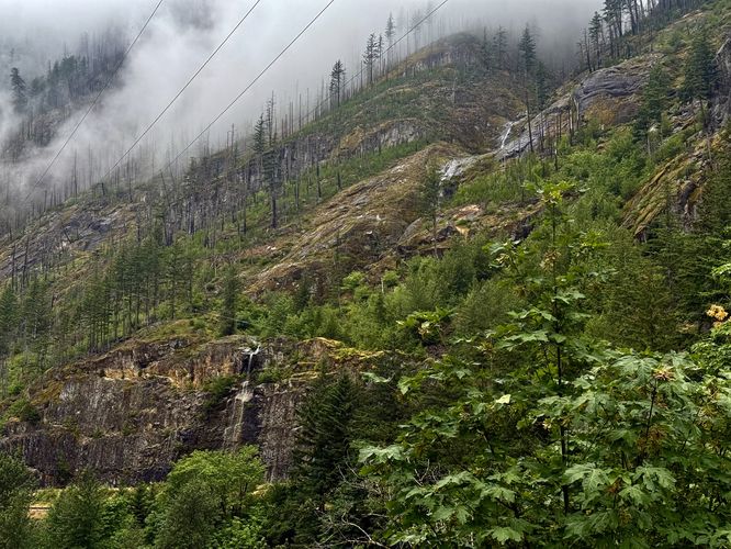
The Newhalem Waterfall Lookout at North Cascades National Park near Newhalem, Washington is a universally-accessible roadside viewpoint that features the multi-tiered, ~600-foot tall waterfall, Newhalem Falls.

Explore Newhalem Falls

This roadside stop, located on the south side of the North Cascades Highway is the safest way to enjoy this massive waterfall that cascades down the mountainside and into the Skagit River. From the parking turnout, you'll have spectacular views of the ~600-foot tall tiers of the Newhalem Waterfall. While the entire waterfall continues further up the mountainside, the lower three tiers of cascades are visible from the road. Please note that I write this overlook is the "safest" area to view the waterfall because just below the lowest tier sit roadblocks and warning signs that are meant to prevent visitors from reaching the base of the waterfall due to dangerous rockfall. The signs at the base of the Newhalem Waterfall would not exist if the area wasn't dangerous with unstable rockfall, so for the best and safest views of this cascade, simply follow this guide to the parking or trailhead coordinates provided.

Last thing to note: the Newhalem Waterfall is best viewed during or after heavy rainfall especially after the spring snowmelt has calmed down.

Universal Access

This parking turnout should be considered universally accessible despite being a dirt lot. Note that you can also view the Newhalem Waterfall and it's ~600-feet of plummeting glory from your vehicle, so you don't necessary need to get out and walk if you don't want to, hence this roadside viewpoint is universally-accessible.

Parking

Visitors will find a small parking turnout at the coordinates provided, located on the south side of the North Cascades Highway just east of Newhalem center. The turnout is large enough to fit less than a dozen vehicles as of June 2025.

Pets

Dogs are allowed only if leashed and must be cleaned up after.

Warning

Steep terrain: Located near the edge of the parking turnout are the best views of the Newhalem Waterfall, but this is also adjacent to a steep hillside that plummets to the Skagit River below. Be aware that not all soil is stable, so stay back from the edge for safety.

No swimming: Note that visitors may want to take a dip in the Skagit River by following a super-steep scramble down from this parking turnout, but due to random and untimed releases of water from the dams upstream, the Skagit River may flood without warning. For your own safety, do not attempt to swim in the Skagit River below this lookout. There are warning signs about this at the parking turnout as a reminder.
Explore 11 trails near Newhalem, WA
  1. Parking

    48.68765, -121.234771
  2. Main Trailhead

    48.68765, -121.234771
  3. View of all 3 tiers of the Newhalem Waterfall

    48.687694, -121.23497
    View of all 3 tiers of the Newhalem Waterfall
No community routes found. To add your own hike as a Community Route for this Trail guide, leave a Trip Report with an attached GPX file.

Hazards

Rockfalls / Ledges / or Scrambles

Seasons

All

Photo Albums

Trip Reports

Trail Guide By:
Admin user profile picture
0 miles / 0 km
Preview of the MyHikes mobile app interface

Track, Log, and Explore Hikes with the MyHikes App

Shop Landscape Prints
Shop our Washington State landscape prints

Weather Forecast

In Newhalem, WA

Explore Hiking Trails

You May Also Like

Colorado's Million Dollar Highway - Plan a day's drive adventure along the iconic Million Dollar Highway in Colorado. Explore the best short trails, roadside stops, waterfalls, vistas, ghost towns, and hot springs within a ~6 hour road trip.
Explore

Colorado's Million Dollar Highway

Plan a day's drive adventure along the iconic Million Dollar Highway in Colorado. Explore the best short trails, roadside stops, waterfalls, vistas, ghost towns, and hot springs within a ~6 hour road trip.

Read
Glacier's Going-to-the-Sun Road - Discover the breathtaking beauty of Glacier National Park along the iconic Going-to-the-Sun Road. From stunning roadside stops to picturesque waterfalls and vistas, this engineering marvel offers endless opportunities for exploration.
Explore

Glacier's Going-to-the-Sun Road

Discover the breathtaking beauty of Glacier National Park along the iconic Going-to-the-Sun Road. From stunning roadside stops to picturesque waterfalls and vistas, this engineering marvel offers endless opportunities for exploration.

Read
New York's Best Waterfalls - Whether you're planning a day hike, roadside stop, or a leisurely short walk, this guide provides hikers, travelers, and locals alike with 63 different locations to over 100 scenic waterfalls to help plan your next adventure!
Explore

New York's Best Waterfalls

Whether you're planning a day hike, roadside stop, or a leisurely short walk, this guide provides hikers, travelers, and locals alike with 63 different locations to over 100 scenic waterfalls to help plan your next adventure!

Read

Before you boogie...

Find our trail guides useful? Consider becoming a Supporter to unlock perks!

MyHikes is an indie platform that makes exploring public trails easier for everyone. The platform has no investors, no ads, and is owned and operated by one person, Dave Miller. Dave has personally mapped and written over 1,800 trail guides on MyHikes for the public to explore. MyHikes has helped millions outdoor enthusiasts plan their next adventure.

But it takes a lot of time 🕦, money 💰, work, and espresso shots ☕ to run MyHikes, including hiking , mapping , writing , and publishing new trails with high-quality (accurate) information... along with software engineering (coding) the platform like building new features, website and mobile app development (iOS and Android), site maintainance . and much much more.

Supporters unlock website and mobile app perks with an annual one-time payment of $25 (you renew) 😎👍. Or you can simply make a Donation of your choice. Otherwise, you can support us by telling your friends about MyHikes - both quick and free 🎉

Admin user profile picture

Dave Miller
MyHikes Founder