Loading...

Distance:
1.0 Mile / 1.6 km
Type:
Out-and-Back
Difficulty:
Easy
Time to Hike:
~30 minutes
Surface Type:
Dirt
Town:
Leverett, Massachusetts
Directions:
42.496727, -72.495638
Added:
December 29, 2018
Updated:
December 29, 2018
Loading...
Loading...
149 '

Total Change
163 '

Ascent
163 '

Descent

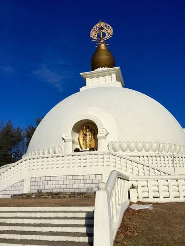
The New England Peace Pagoda Trail in Leverett, Massachusetts is an easy 1 mile out-and-back hike to North America's first peace pagoda.

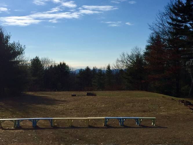
This is a gravel trail that leads up a small hill towards the monument. At the top of the hill lies the peace pagoda, a peace tree, pond, and stone garden area. During the colder months, you can often get a views of the surrounding mountains through the tops of the trees from the viewing area near the monument.

The physically challenged and elderly are encouraged to drive up to the monument instead of walking up.

Parking: Parking can be found at the first dirt parking lot on the right-hand side of the road just after turning onto the road at the peace pagoda sign off of Cave Hill Rd in Leverett.

Learn more about the New England Peace Pagoda here.

Explore 199 trails near Leverett, MA
  1. Parking

    42.496727, -72.495638
  2. Main Trailhead

    42.496748, -72.495539
  3. View from the pagoda

    42.498775, -72.491172
    View from the pagoda
  4. New England Peace Pagoda

    42.4987, -72.491103
    New England Peace Pagoda
No community routes found. To add your own hike as a Community Route for this Trail guide, leave a Trip Report with an attached GPX file.

Hazards

Ticks - Lyme Disease More Info (CDC)

Seasons

All

Photo Albums

1 Trip Report

No Star-Ratings
Write-up by:
Admin user profile picture
1.0 mile / 1.6 km
Trail added
December 29, 2018
Hiked on
December 26, 2018
Updated on
December 29, 2018

Weather Forecast

In Leverett, MA

Explore Hiking Trails

New Hikes

Cold Run Waterfalls & Vista Loop
3.1 Miles
5 km
Moderate
Loop
Eternal Flame Falls via Eternal Flame Trail
1.2 Miles
1.9 km
Moderate
Out-and-Back
Silver Cascade
0.2 Miles
0.3 km
Easy
Out-and-Back
Angel Falls Loop
2.8 Miles
4.5 km
Moderate
Loop

Before you leave...

MyHikes is an indie web platform aimed to make exploring public trails easier for everyone. The site has no investors and is owned and operated by one person, Dave Miller (Founder & Admin). As the Founder, main contributor, and doer-of-all-things for MyHikes, I share my trips with over-detailed write-ups for fun on a volunteer basis and I believe that public trail information should be available to everyone.

It takes a lot of time 🕦, money 💰, and effort (including espresso shots ☕) to run MyHikes, including hiking , mapping , writing , and publishing new trails with high-quality content... along with building new features, moderating, site maintainance, and app development for iOS and Android . I simply ask that if you find MyHikes' trail guides helpful to please consider becoming a Supporter to help keep the site, iOS, and Android apps available to everyone.

Supporters unlock website and in-app perks with a one-time payment of $25 (you renew) 😎👍. Or you can simply make a Donation of your choice without a MyHikes user account. Otherwise, telling your friends about MyHikes is the next-best thing - both quick and free 🎉

Thanks for visiting MyHikes and have a great hike!️

Admin user profile picture

Dave Miller
MyHikes Founder & Admin