The Narada Falls Trail at Mt. Rainier National Park near Ashford, WA is a moderate 0.2-mile out-and-back hike that leads to spectacular views of the 188-foot tall waterfall, Narada Falls.
The trailhead for Narada Falls can be found on the eastern side of the stone bridge where the Narada Falls Trail leads hikers downhill at a moderate grade. The trail can often be muddy and includes some larger steps, so watch your step out on your way down.
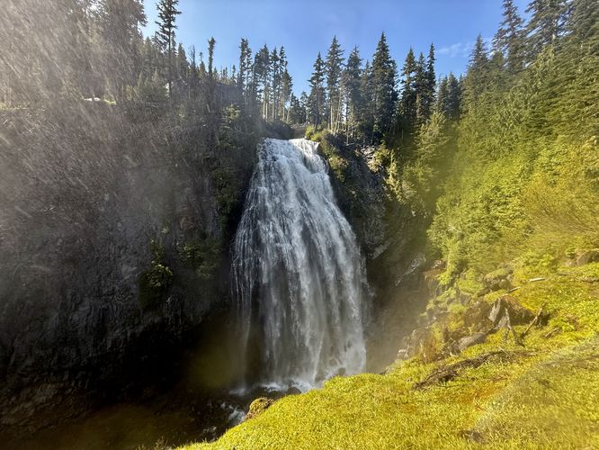
Eventually, the trail leaves the forest where it opens up with views of the 188-foot tall Narada Falls as it plummets over a cliff in the Paradise River. During late spring and early summer, Narada Falls is roaring with snow melt and often creates plumes of mist that fill the air, surrounding the trail. Due to this, taking nice photos of Narada Falls in its entirety can be a challenge. Hikers may want to walk all the way to the end of the viewing platform where you'll get a full view of the 188-foot tall waterfall, but in doing so, you might also get soaking wet. On a hot day after you've cruised around other trails at Mt. Rainier National Park's Paradise area, the mist of water is a welcoming feature along the hike.
After exploring the views of Narada Falls from the trail, the hike leads back to the parking lot as it climbs out from the Paradise River gorge. End the walk around mile 0.24 near the parking lot.
Swift currents: The Paradise River is a very strong-flowing body of water that carries snow and glacial melt from higher elevations on Mt. Rainier's slopes. Due to this, it's important that you stay out of the river at all times, especially just upstream from Narada Falls. One false slip in the river will likely mean that you'll find yourself plummeting ~180-feet down the waterfall to your death.
Explore Narada Falls
The hike to Narada Falls begins at the main parking lot where visitors will find a stone bridge that spans the Paradise River. Here, you'll find scenic upstream views of the Paradise River to the north and views from the top of Narada Falls with jagged alpine peaks in the distance, like Lane Peak.The trailhead for Narada Falls can be found on the eastern side of the stone bridge where the Narada Falls Trail leads hikers downhill at a moderate grade. The trail can often be muddy and includes some larger steps, so watch your step out on your way down.
Eventually, the trail leaves the forest where it opens up with views of the 188-foot tall Narada Falls as it plummets over a cliff in the Paradise River. During late spring and early summer, Narada Falls is roaring with snow melt and often creates plumes of mist that fill the air, surrounding the trail. Due to this, taking nice photos of Narada Falls in its entirety can be a challenge. Hikers may want to walk all the way to the end of the viewing platform where you'll get a full view of the 188-foot tall waterfall, but in doing so, you might also get soaking wet. On a hot day after you've cruised around other trails at Mt. Rainier National Park's Paradise area, the mist of water is a welcoming feature along the hike.
After exploring the views of Narada Falls from the trail, the hike leads back to the parking lot as it climbs out from the Paradise River gorge. End the walk around mile 0.24 near the parking lot.
Parking & Fees
Hikers will find a large parking lot at the coordinates provided, located on the east side of the Paradise-to-Longmire Road at the park. The lot is large enough to fit several dozen vehicles as of June 2025. As of June 2025, there's a $25 entry fee for the park which is good for several days. If you plan ahead, you can speed up your entry with an Annual National Park's Pass.Pets
All pets, including dogs, are not allowed on any trails within Mt. Rainier National Park, so please leave your dogs at home.Warning
Cliffs: This trail follows steep cliffs that plummet over 180-feet into the Paradise River gorge. For your own safety, stay on-trail.Swift currents: The Paradise River is a very strong-flowing body of water that carries snow and glacial melt from higher elevations on Mt. Rainier's slopes. Due to this, it's important that you stay out of the river at all times, especially just upstream from Narada Falls. One false slip in the river will likely mean that you'll find yourself plummeting ~180-feet down the waterfall to your death.