Loading...

๐ŸŽ‰ Enjoy a Free 7-Day Supporter Trial and Unlock Exclusive Perks โ€” No Credit Card Required. Learn more.

Mt Willard Overlook Trail

Directions
Map
Pictures
Send to App
Distance:
3.2 Miles / 5.1 km
Type:
Out-and-Back
Difficulty:
Hard
Time to Hike:
1 hour, ~36 minutes
Features:
Surface Type:
Dirt
Park:
White Mountain National Forest
Town:
Carroll, New Hampshire
Directions:
44.223301, -71.411499
Added:
May 24, 2013
Updated:
October 25, 2018
Copy Trail Link Hiking this trail? Send a friend or family member a link to this trail guide for your own safety. Hike at your own risk (disclaimer)
Loading...
Loading...
939'

Total Change
987'

Ascent
990'

Descent

Download the Trail Route for Offline Use

Supporters get exclusive access to download trail routes to the MyHikes app for offline use. Stay prepared on your adventure, even without an internet connection! Become a Supporter today to unlock this feature and hike with confidence.

Send to App

Mt Willard Overlook Trail

The Mt Willard Overlook Trail is a 3.2 mile out-and-back hike in the White Mountains of New Hampshire. 
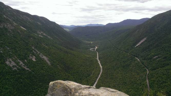
At the top of Mount Willard is an amazing valley-swept view of the Crawford Notch area. The trail starts directly behind the Crawford Notch Station, but you need to cross the train tracks to hit the trail. Once you cross the tracks, you should see a sign post with signs for Mount Willard. The trail itself is difficult as almost the entire hike is uphill. Parts of the trail are large rocks that you end up using as a natural staircase to climb Mount Willard. Carrying a pack up this mountain can be challenging in itself, so if you don't plan to camp, this is a great day hike.

Camping: camping here is not allowed within ~200 feet of the cliff, but there are a couple of spots you can fit a small tent into within the boundary behind it. The forest near the top of Mount Willard is mostly coniferous and the trees aren't very old - the downside is there's a lot of underbrush, so finding a spot for a tent can also be a challenge. Hammock camping may be easier near the top of Mount Willard.

Hiking poles can help the downhill on this hike due to the large boulder steps.

Parking: parking is available at your first left on Mount Clinton Road and there is a fee for each day parked, which is about $5 per day. Only downside to parking here is that you have to walk back down the road to reach the trailhead.ย 

For more info read through this link
Explore 17 trails near Carroll, NH
  1. Parking

    44.223301, -71.411499
  2. Main Trailhead

    44.217255, -71.412708
  3. Mt Willard Overlook

    44.203712, -71.411315
    Mt Willard Overlook
No community routes found. To add your own hike as a Community Route for this Trail guide, leave a Trip Report with an attached GPX file.

Hazards

Ticks - Lyme Disease More Info (CDC)

Season

Spring

Photo Albums

Trip Reports

Trail Guide By:
Admin user profile picture
3.2 miles / 5.1 km
3.2 miles / 5.1 km
May 24, 2013
Camping Hiking

Weather Forecast

In Carroll, NH

Explore Hiking Trails

You May Also Like

Colorado's Million Dollar Highway - Plan a day's drive adventure along the iconic Million Dollar Highway in Colorado. Explore the best short trails, roadside stops, waterfalls, vistas, ghost towns, and hot springs within a ~6 hour road trip.
Explore

Colorado's Million Dollar Highway

Plan a day's drive adventure along the iconic Million Dollar Highway in Colorado. Explore the best short trails, roadside stops, waterfalls, vistas, ghost towns, and hot springs within a ~6 hour road trip.

Read
Glacier's Going-to-the-Sun Road - Discover the breathtaking beauty of Glacier National Park along the iconic Going-to-the-Sun Road. From stunning roadside stops to picturesque waterfalls and vistas, this engineering marvel offers endless opportunities for exploration.
Explore

Glacier's Going-to-the-Sun Road

Discover the breathtaking beauty of Glacier National Park along the iconic Going-to-the-Sun Road. From stunning roadside stops to picturesque waterfalls and vistas, this engineering marvel offers endless opportunities for exploration.

Read
New York's Best Waterfalls - Whether you're planning a day hike, roadside stop, or a leisurely short walk, this guide provides hikers, travelers, and locals alike with 63 different locations to over 100 scenic waterfalls to help plan your next adventure!
Explore

New York's Best Waterfalls

Whether you're planning a day hike, roadside stop, or a leisurely short walk, this guide provides hikers, travelers, and locals alike with 63 different locations to over 100 scenic waterfalls to help plan your next adventure!

Read

Before you boogie...

Find our trail guides useful? Consider becoming a Supporter to unlock perks!

MyHikes is an indie platform that makes exploring public trails easier for everyone. The platform has no investors, no ads, and is owned and operated by one person, Dave Miller. Dave has personally mapped and written over 1,800 trail guides on MyHikes for the public to explore. MyHikes has helped millions outdoor enthusiasts plan their next adventure.

But it takes a lot of time ๐Ÿ•ฆ, money ๐Ÿ’ฐ, work, and espresso shots โ˜• to run MyHikes, including hiking , mapping , writing , and publishing new trails with high-quality (accurate) information... along with software engineering (coding) the platform like building new features, website and mobile app development (iOS and Android), site maintainance . and much much more.

Supporters unlock website and mobile app perks with an annual one-time payment of $25 (you renew) ๐Ÿ˜Ž๐Ÿ‘. Or you can simply make a Donation of your choice. Otherwise, you can support us by telling your friends about MyHikes - both quick and free ๐ŸŽ‰

Admin user profile picture

Dave Miller
MyHikes Founder