Loading...

WINTER SALE! 50% OFF Supporter Accounts — now through January 31st. Learn More.

Eyrie House Ruins Trail

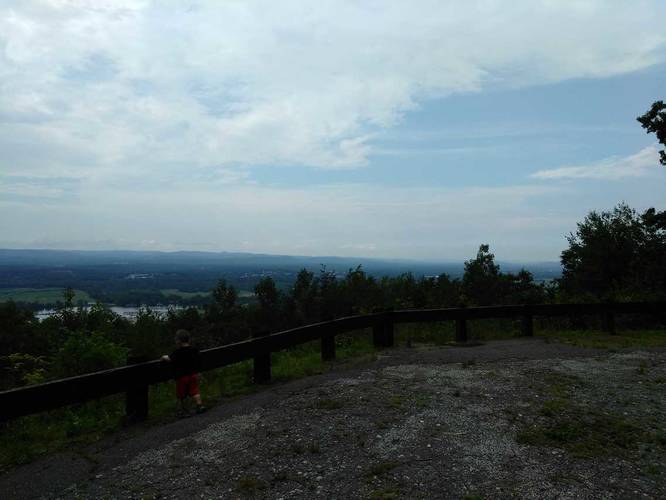
The Eyrie House Ruins Trail is a 2.4 mile out-and-back hike up to the hotel ruins of the Eyrie House and the summit of Mount Nonotuck in the Mount Tom Reservation in Massachusetts. Follow the M & M trail (white blazes) from the trailhead listed on the map to the access road. Once you reach the access road follow it up the mountain and it will lead to a lookout and the entrance the Eyrie House Ruins. Continue following the trail and it will bring you to the summit of Mount Nonotuck.

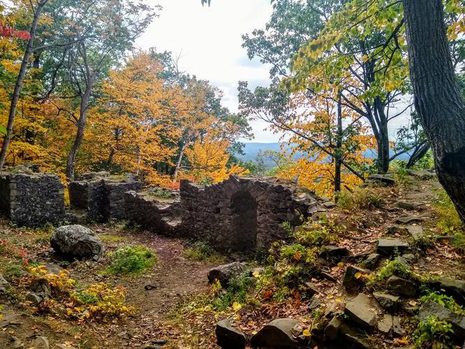
The Eyrie House was a hotel that burned to the ground in 1901, but was a popular destination in the 1880's up until the fire. All that's left now is the ruins of the old hotels, but this is a really awesome hike and a hidden gem in western Massachusetts.

Pets
Dogs are allowed if leashed and their waste must be carried out by the hiker.

Parking
Please note that this trailhead and parking area is located on a residential street. All hikers must respect the private owners and neighbors located next to the trailhead. If parking cannot be found at the trailhead due to a crowded day, please stay off of all private land and find a public place to park.
Explore 207 trails near Easthampton, MA

Know Before You Go

  • The Eyrie House Ruins Trail in Easthampton, MA is a 2.4-mile hike to the ruins of the Eyrie House hotel and the summit of Mount Nonotuck.
  • The trail follows the M & M trail (white blazes) to an access road, which leads to the ruins and the summit.
  • Hikers should be respectful of the residential area surrounding the trailhead, keeping dogs leashed and carrying out waste, and parking only in designated or public areas.
Interactive topographic map for Eyrie House Ruins Trail located in Easthampton, MA. Click the "View Map" button to load GPS coordinates and trail markers.
Get directions
Distance
2.4 mi
Difficulty
Moderate
Type
Out-and-Back
Est. Time
1.2 hrs
Elev. Gain
670'
Rating
0.0
Added
September 04, 2017
Updated
June 15, 2020

Weather Forecast

Loading...
Total Change
647'
Ascent
670'
Descent
670'
Loading...

Download the GPX Data for Offline Use

Supporters get exclusive access to download trail routes to the MyHikes app for offline use. Stay prepared on your adventure, even without an internet connection! Become a Supporter today to unlock this feature and hike with confidence.

Download Eyrie House Ruins Trail GPX Data to the MyHikes Mobile App

Features

Vista / Lookout Point
Dogs
Mountain Summit

Points of interest

  1. Parking

    42.285291, -72.620277
  2. Main Trailhead

    42.285336, -72.62051
  3. Vista near the summit

    42.279747, -72.62167
    Vista near the summit
  4. Eyrie House ruins

    42.280348, -72.62037
    Eyrie House ruins

Safety information

For your own safety: plan ahead, let someone know where you'll be, and hike at your own risk.

Markers

Blaze Color

White

Availability

Summer

Surface type

Dirt

Trip Reports (Reviews)

Your opinion matters! Be the first to rate this trail.

Ready to help fellow hikers? Add a trip report to share your experience and provide valuable insights for other hikers!

2.4 miles / 3.9 km
May 15, 2021
Hiking
2.4 miles / 3.9 km
September 27, 2020
Hiking
2.4 miles / 3.9 km
March 04, 2018
First trail after the snow melted! :)
Hiking
No community routes found. To add your own hike as a Community Route for this Trail guide, leave a Trip Report with an attached GPX file.

Popular categories

Scenic mountain view representing vista trails
Vista trails
Scenic gorge of cascades representing waterfall trails
Waterfall hikes
Rugged mountain terrain representing summit trails
Summit trails
Scenic mountain view representing dog-friendly trails
Dog-friendly
Scenic campsite with a view representing camping trails
Camping trails
Appalachian Trail logo representing A.T. hikes
A.T. hikes

You May Also Like

Colorado's Million Dollar Highway - Plan a day's drive adventure along the iconic Million Dollar Highway in Colorado. Explore the best short trails, roadside stops, waterfalls, vistas, ghost towns, and hot springs within a ~6 hour road trip.
Explore

Colorado's Million Dollar Highway

Plan a day's drive adventure along the iconic Million Dollar Highway in Colorado. Explore the best short trails, roadside stops, waterfalls, vistas, ghost towns, and hot springs within a ~6 hour road trip.

Read
Glacier's Going-to-the-Sun Road - Discover the breathtaking beauty of Glacier National Park along the iconic Going-to-the-Sun Road. From stunning roadside stops to picturesque waterfalls and vistas, this engineering marvel offers endless opportunities for exploration.
Explore

Glacier's Going-to-the-Sun Road

Discover the breathtaking beauty of Glacier National Park along the iconic Going-to-the-Sun Road. From stunning roadside stops to picturesque waterfalls and vistas, this engineering marvel offers endless opportunities for exploration.

Read
🍪 We use cookies to learn about site usage and to serve map tiles. You may block cookies manually in the browser. By continuing you agree. Learn more