Mt. Tammany Trail at Delaware Water Gap National Recreation Area near Hardwick Township, New Jersey is a difficult 2.5-mile out-and-back hike that features stunning views of Mt. Minsi and the Delaware River.
Trails
This hike follows one named trail: Mt. Tammany Trail (white blazes with red dots).
Hike Description
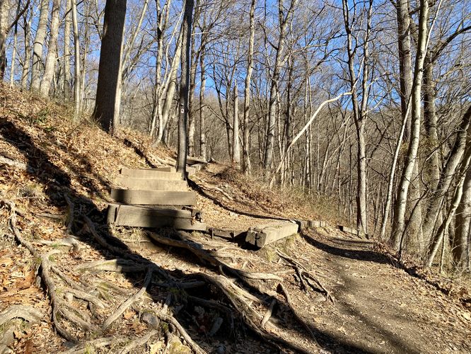
This hike begins at the main trailhead for the Mt. Tammany Trail, located at the Appalachian Trail trailhead parking lot for the Dunfield Creek section. The trailhead is located near the entrance to the parking lot, on the east side of the road. The trail heads into the woods and makes a left-hand turn at the first staircase. The trail then follows an open forest along "flat" terrain for just a short while before the rocky mountainous terrain of the trail begins.
Rocky Terrain Begins - Mile 0.2
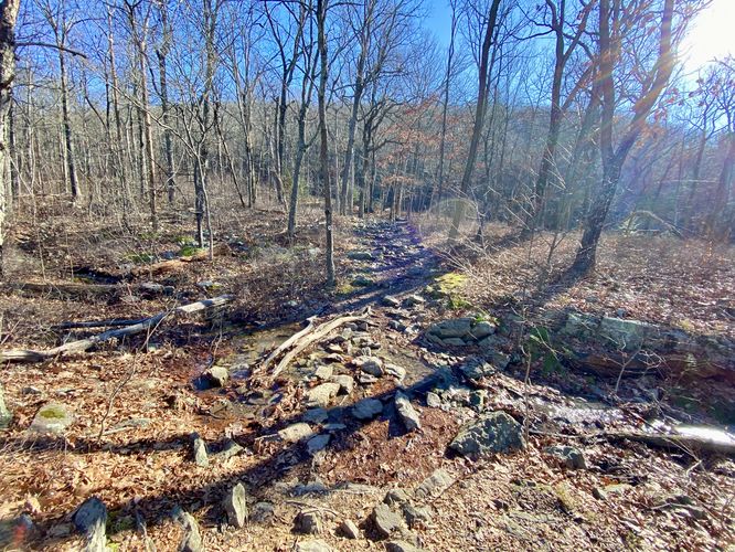
At mile 0.2, the trail turns into mostly a rock path, which lasts for a good portion of the hike. The trails surface will transition to and from a rock-filled surface to leaf-covered forest floor, but for the most part, plan on rocks most of the way.
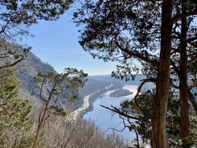
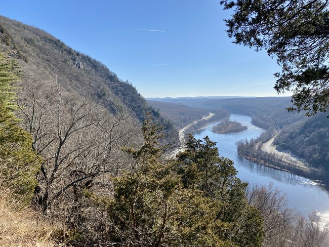
Delaware River & Mt. Minsi Views - Mile 0.4 to 0.45
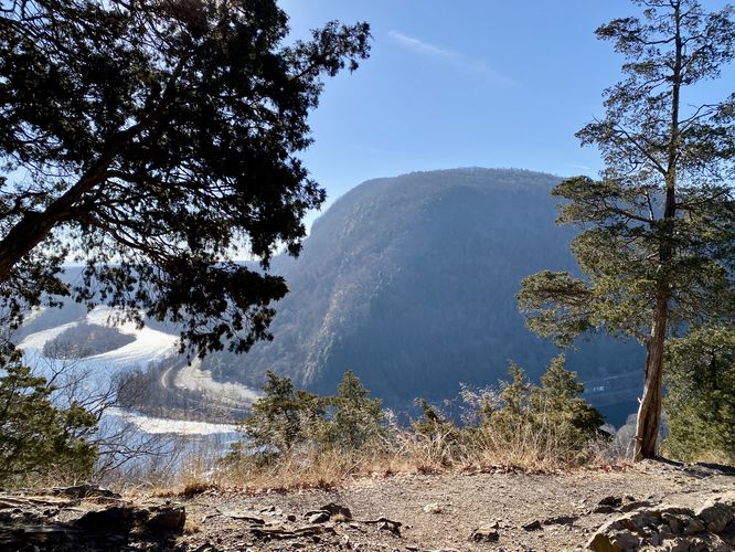
At mile 0.4, the trail will flatten out slightly as it opens up to cliff side views of Mt. Minsi across the way, the Delaware River below your feet, and Mt. Tammany's steep slopes and cliffs to your left-hand side. There are several spots to get views of the area -- some provide similar views, others block out Mt. Minsi almost entirely. Hikers can enjoy the views and take a short break here to relax a bit from the initial climb up Mt. Tammany's slopes.
Creek Crossing - Mile 0.6
Around mile 0.6 is a shallow creek crossing. If in need, this water can probably be filtered.
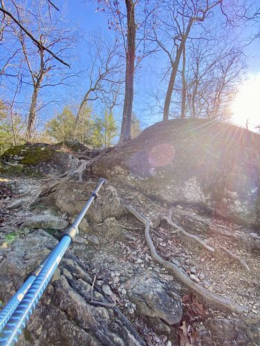
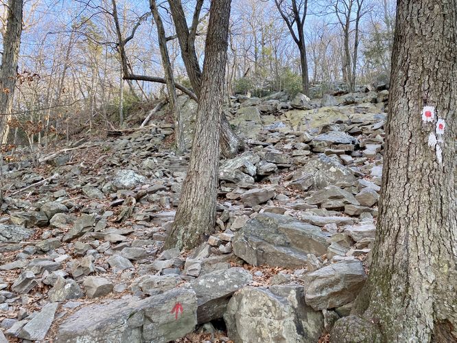
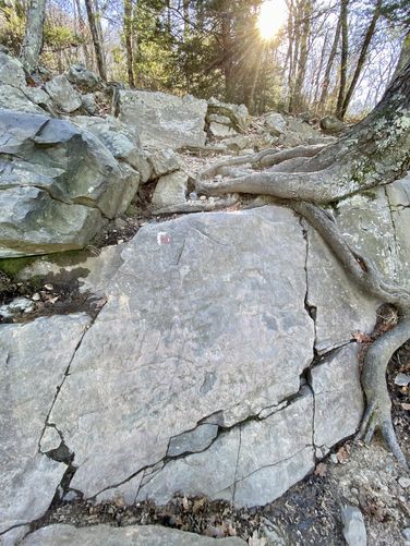
Rock Ledges / Hard-to-Follow Trail - Mile 0.7 to 0.8
At mile 0.7, the trail will reach a large rock outcropping on the mountain. Here, the path snakes its way up the rocks along a mostly-safe path. Due to the jagged rocks and small ledges here, it's best to watch your step and take this section slow -- especially if there's a traffic jam of other hikers. During colder months, the cracks, crevasses, and crags will also include slippery ice that builds up. During the middle of Winter months, you'll want to bring microspikes at the very least if not real crampons and an ice axe to stay safe.
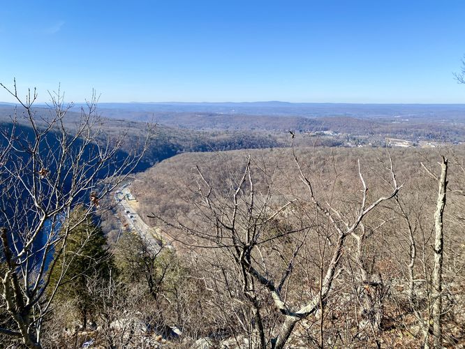
Off-Trail View of Pennsylvania - Mile 0.9
Around mile 0.9, there's an off-trail rocky outcropping that provides views into Pennsylvania - as of December 2023. In the future this view might be filled-in by the trees in the area. After this off-trail view, the hike leads up the mountain once more which is your last real ascent while hiking the trail and it ends around mile 1.1.
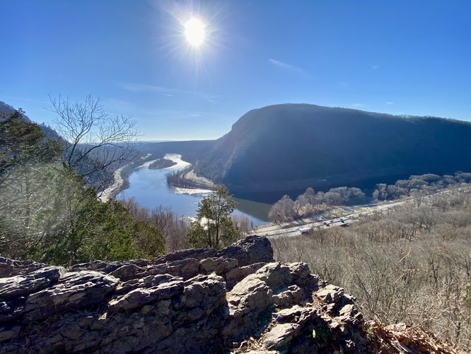
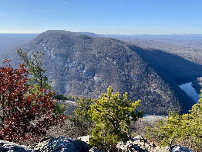
Mt. Tammany Lookout - Mile 1.2 to 1.25
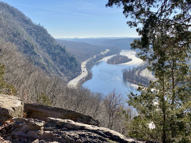
At mile 1.2, the trail will turn to head southward where it leads into a large open rock outcropping. This is the top of Mt. Tammany's exposed rock slide and cliff area. Here, hikers will get the best view along the trail with Mt. Minsi across the way and the Delaware River below your feet. Hikers can head down the bedrock to get a better view and to take in the sights from the top of Mt. Tammany. Mt. Minsi sits across the way with its stripped striations that line its mountainous slopes. For those who've already hiked Mt. Minsi, you'll notice the striations are very similar to Mt. Tammany's. Hikers should chill and enjoy the view for as long as they want before continuing onward. During my hike here, I had to leave ASAP so I hiked this out-and-back; however, most people are into the popular loop hike here which connects down to the Dunfield Creek section of the Appalachian Trail -- choose your own adventure.
Hiking Out - Mile 1.25 to 2.5
This track heads back to parking via and out-and-back hike (due to a lack of time); however, hikers should note that the hike down the mountain, while generally faster, is definitely harder. It was much easier to traverse up the bedrock and jagged rocks than it was to hike down. I brought 2 trekking poles for this hike -- unlike most other hikers -- and found that traversing the mountain, while difficult, was a lot easier with trekking poles than it would've been without them. Watch your step, find sure footing, and be extra careful around the rock ledge outcropping section of the trail.
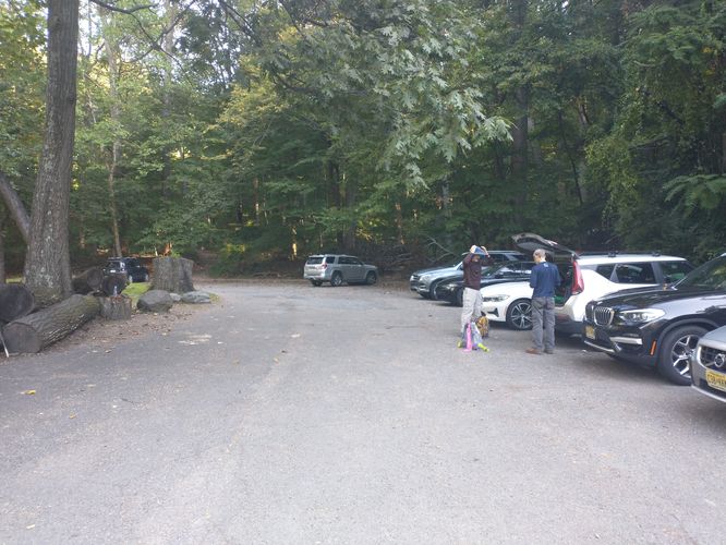
Parking
Hikers will find two very large parking lots -- the main lot is at the parking coordinates provided. The other lot is located to the east of this one at 40.971713, -75.122579. For folks driving on I-80 westbound, you can easily hop on this trail as the exit goes almost directly to the parking lot. Both parking lots are large enough to fit a few dozen vehicles. During the Summer, these lots fill up quickly, but less so during cold months.
Pets
Dogs are allowed only if leashed and must be cleaned up after.
Popularity
This is one of the most-popular day hikes within Delaware Water Gap National Recreation Area, especially due to its easy access from I-80 and proximity to NYC. During warm months, expect to see the parking lots very full most times of the day. If you wish to hike this without many people, aim for very early morning or the late evening.
Warnings
Rocky terrain: This hike follows plenty of rocky sections where its easy to slip, roll or twist an ankle.
Rock ledges: Part of this hike follows rock ledges -- while they are not very tall, they can still be dangerous. Watch your step. During Winter months, it's smart to bring, at the very least, microspikes / ice spikes for the rocky terrain as a lot of water builds up into ice chunks.
Trails
This hike follows one named trail: Mt. Tammany Trail (white blazes with red dots).
Hike Description
This hike begins at the main trailhead for the Mt. Tammany Trail, located at the Appalachian Trail trailhead parking lot for the Dunfield Creek section. The trailhead is located near the entrance to the parking lot, on the east side of the road. The trail heads into the woods and makes a left-hand turn at the first staircase. The trail then follows an open forest along "flat" terrain for just a short while before the rocky mountainous terrain of the trail begins.
Rocky Terrain Begins - Mile 0.2
At mile 0.2, the trail turns into mostly a rock path, which lasts for a good portion of the hike. The trails surface will transition to and from a rock-filled surface to leaf-covered forest floor, but for the most part, plan on rocks most of the way.
Delaware River & Mt. Minsi Views - Mile 0.4 to 0.45
At mile 0.4, the trail will flatten out slightly as it opens up to cliff side views of Mt. Minsi across the way, the Delaware River below your feet, and Mt. Tammany's steep slopes and cliffs to your left-hand side. There are several spots to get views of the area -- some provide similar views, others block out Mt. Minsi almost entirely. Hikers can enjoy the views and take a short break here to relax a bit from the initial climb up Mt. Tammany's slopes.
Creek Crossing - Mile 0.6
Around mile 0.6 is a shallow creek crossing. If in need, this water can probably be filtered.
Rock Ledges / Hard-to-Follow Trail - Mile 0.7 to 0.8
At mile 0.7, the trail will reach a large rock outcropping on the mountain. Here, the path snakes its way up the rocks along a mostly-safe path. Due to the jagged rocks and small ledges here, it's best to watch your step and take this section slow -- especially if there's a traffic jam of other hikers. During colder months, the cracks, crevasses, and crags will also include slippery ice that builds up. During the middle of Winter months, you'll want to bring microspikes at the very least if not real crampons and an ice axe to stay safe.
Off-Trail View of Pennsylvania - Mile 0.9
Around mile 0.9, there's an off-trail rocky outcropping that provides views into Pennsylvania - as of December 2023. In the future this view might be filled-in by the trees in the area. After this off-trail view, the hike leads up the mountain once more which is your last real ascent while hiking the trail and it ends around mile 1.1.
Mt. Tammany Lookout - Mile 1.2 to 1.25
At mile 1.2, the trail will turn to head southward where it leads into a large open rock outcropping. This is the top of Mt. Tammany's exposed rock slide and cliff area. Here, hikers will get the best view along the trail with Mt. Minsi across the way and the Delaware River below your feet. Hikers can head down the bedrock to get a better view and to take in the sights from the top of Mt. Tammany. Mt. Minsi sits across the way with its stripped striations that line its mountainous slopes. For those who've already hiked Mt. Minsi, you'll notice the striations are very similar to Mt. Tammany's. Hikers should chill and enjoy the view for as long as they want before continuing onward. During my hike here, I had to leave ASAP so I hiked this out-and-back; however, most people are into the popular loop hike here which connects down to the Dunfield Creek section of the Appalachian Trail -- choose your own adventure.
Hiking Out - Mile 1.25 to 2.5
This track heads back to parking via and out-and-back hike (due to a lack of time); however, hikers should note that the hike down the mountain, while generally faster, is definitely harder. It was much easier to traverse up the bedrock and jagged rocks than it was to hike down. I brought 2 trekking poles for this hike -- unlike most other hikers -- and found that traversing the mountain, while difficult, was a lot easier with trekking poles than it would've been without them. Watch your step, find sure footing, and be extra careful around the rock ledge outcropping section of the trail.
Parking
Hikers will find two very large parking lots -- the main lot is at the parking coordinates provided. The other lot is located to the east of this one at 40.971713, -75.122579. For folks driving on I-80 westbound, you can easily hop on this trail as the exit goes almost directly to the parking lot. Both parking lots are large enough to fit a few dozen vehicles. During the Summer, these lots fill up quickly, but less so during cold months.
Pets
Dogs are allowed only if leashed and must be cleaned up after.
Popularity
This is one of the most-popular day hikes within Delaware Water Gap National Recreation Area, especially due to its easy access from I-80 and proximity to NYC. During warm months, expect to see the parking lots very full most times of the day. If you wish to hike this without many people, aim for very early morning or the late evening.
Warnings
Rocky terrain: This hike follows plenty of rocky sections where its easy to slip, roll or twist an ankle.
Rock ledges: Part of this hike follows rock ledges -- while they are not very tall, they can still be dangerous. Watch your step. During Winter months, it's smart to bring, at the very least, microspikes / ice spikes for the rocky terrain as a lot of water builds up into ice chunks.