This hike is an extended version of the Wilburn Ridge/Pine Mountain loop that includes two overnight stays and an optional side trip to the Mount Rogers summit. This 2.5 day itinerary is set up for hikers with a long drive on the first and last day of the hike. Alternatively the hike can be completed in 2 days by staying overnight near the Scales or Wise Shelter, or by using the Pine Mountain Trail to shorten the route.
The Mount Rogers/Grayson Highlands area is one of the premier hiking spots on the East Coast, featuring sweeping vistas and highland meadows. The majority of the hike follows the Appalachian Trail from VA Route 603 to Deep Gap as it detours through the park to take in the stunning views. Wild ponies and local herds of cattle are allowed to range throughout the park to help manage and maintain the open balds.
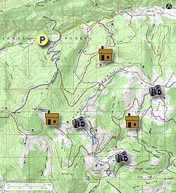
The hike starts out from the Grindstone Campground, which charges $3/night per vehicle for backpackers parking there. There are also two free parking lots at the Fairwood Valley and Fox Creek trailheads on Rte 603 - however, other hikers have reported car break-ins at these locations in the past.
Note – The original Grindstone entrance to the Mount Rogers Tie Trail has been closed since 2011 due to a tornado blowdown. There is an unofficial, cleared (if overgrown) access route through the blowdown to reach the trail from the Grindstone Campground outlined below. An alternate route is to exit the campground through the main entrance and turn right to walk along the shoulder of Rte 603 for 0.4 miles to reach the Fairwood Valley trailhead at Mile 0.8.
Day One – 4.1 miles / 2.0 hours
- Mile 0.0 – From the Grindstone parking lot, head back towards the entrance station and take a right onto the Opossum Hollow Loop followed by an immediate left. Take the gravel path opposite Site #10 and turn left 200 feet up the path at a small pile of stones to get onto the Mount Rogers Tie Trail. After 250 feet the trail enters the forest and becomes clear of underbrush and debris. In 300 yards the Tie Trail meets the blue-blazed Mount Rogers Trail. Turn left and follow it for 400 yards until it crosses Rte 603 and reaches the Fairwood Valley Trail, which is marked by a yellow vehicle barrier at the far end of the grassy parking area.
- Mile 0.8 – Turn right onto the Fairwood Valley Horse Trail as it parallels Rte 603 for 1.8 miles, passing through a small pasture and crossing Fox Creek and Lewis Fork. At the Lewis Fork crossing there is a signed “High Water Route” along the roadside in the event that the creek is too high to cross.
- Mile 2.6 – After passing the Lewis Fork and Old Orchard Horse Trails, the trail intersects the white-blazed Appalachian Trail. Turn right onto the AT and cross Rte 603 at the Fox Creek parking lot.
- Mile 4.1 – After intersecting the Old Orchard Horse Trail at Mile 3.4, the AT reaches the Old Orchard Shelter. There is a spring located 120 yards WSW of the shelter at the end of a blue-blazed trail, as well as a privy a short distance to the east. Numerous clearings and open spaces around the shelter provide plenty of space to set up tents for the night.
- Mile 4.1 – Continue following the AT south past the Old Orchard Shelter, crossing the border of the Lewis Fork Wilderness several times as the trail heads uphill.
- Mile 5.6 – Reach the crest of Pine Mountain, where the blue-blazed Pine Mountain Trail intersects the AT from the right. At this point, the hike can be shortened ~5.8 miles by taking the Pine Mountain Trail and following Miles 7.1 to 9.3 of the Wilburn Ridge/Pine Mountain hike to reconnect with the AT at Mile 13.6 below. Pass through a horse gate and continue following the AT as it veers eastward and descends.
- Mile 6.9 – The forest begins to fall away shortly before reaching the Scales. The AT passes directly through the middle of the paddock and continues up the bare slope of Stone Mountain to the south. There are many excellent views of Scales and the surrounding peaks as the trail rises.
- Mile 8.0 – The AT passes through a horse gate and reenters the forest shortly before intersecting with the Bearpen Trail.
- Mile 9.3 – The AT intersects the Scales Trail before crossing a plank bridge over Wilson Creek to an intersection with the Wilson Creek Trail. Shortly afterwards the trail crosses a second bridge over Big Wilson Creek.
- Mile 9.7 – Use an A-frame step ladder to cross a horse fence and pass the Wise Shelter on the left.
- Mile 10.1 – Turn right as the AT joins an old sunken road. The road runs parallel to the Grayson Highlands/Lewis Fork Wilderness border for 0.4 miles before the AT splits off at a horse gate to the left and crosses a plank bridge over the Quebec Branch. After crossing the stream, the trail begins to ascend Wilburn Ridge.
- Mile 11.1 – The AT emerges onto the open crest of Wilburn Ridge. The trail follows the ridgeline among exposed rock formations with uninterrupted views of the surrounding peaks and valleys.
- Mile 11.6 – The AT crosses the gravel Virginia Highlands Connector just north of Massie Gap. Continue following the white blazes as numerous horse trails and traces crisscross the ridge.
- Mile 12.0 – The AT turns north and crosses an open field. Just past a wooden fence at the far side, the AT intersects with the Virginia Highlands Trail, Springs Trail, and Rhododendron Gap Trail.
- Mile 12.4 – Turn left onto the dark-blue-on-light-blue blazed Wilburn Ridge Trail. The trail passes over the summit of Wilburn Ridge and runs parallel to the AT 50-100 yards to the east. This detour features several short rock scrambles and offers unparalleled views of the Mount Rogers area. Otherwise, continue following the AT to where the Wilburn Trail rejoins it in 0.7 miles.
- Mile 12.6 – The trail climbs over a smaller rock outcropping before descending to reach the higher peak to the north.
- Mile 13.0 – Reach the peak of Wilburn Ridge at ~5,520 feet. At the top of the trail there is a short path of loose rock to the right which offers an easy route to the summit. The trail descends the north side of the peak to rejoin the AT in 0.1 miles.
- Mile 13.6 – The AT skirts around the Pine Mountain summit before meeting with the Crest Trail and Pine Mountain Trail. A rocky outcropping directly to the north provides an excellent view of the Iron Mountains to the north and Mount Rogers to the west. Turn left and continue following the AT westward along the ridgeline.
Note – There is a spring which can be reached by turning left down the Crest Trail and following it 0.2 miles downhill to the intersection with the Rhododendron Gap Trail. The Crest Trail spring is generally more dependable in dry months than the spring at Thomas Knob Shelter and may be used as a backup source of water.
-
Mile 14.6 – Reach Thomas Knob Shelter for the night. The shelter features a second story loft which can accommodate additional hikers. There is a small spring located 125 yards downhill behind the shelter by a fenced enclosure. A privy is located just past the shelter, and there are several campsites along the trail in either direction.
Optional Mt. Rogers Peak – 1.0 miles / 0.5 hours
The 0.5 mile blue-blazed Mount Rogers Spur Trail lies just past the Thomas Knob Shelter off the right of the AT. The Mt. Rogers summit is the highest point in Virginia at 5,729 feet, but the peak itself offers no views. Instead, the mountaintop is covered with a rare island of Fraiser firs and red cedar left over from the last Ice Age, which are found only on the highest sections of the Appalachians. This short detour can be taken at the end of Day Two or before setting out on Day Three.
- Mile 14.7 – Turn right off the AT onto the blue-blazed Mount Rogers Spur Trail. In 0.25 miles the trail enters the spruce-fir forest surrounding the peak.
- Mile 15.1 – Reach the summit, which is marked by a semi-open area with several large boulders. The National Geodetic Survey station disk marking the highest point and one reference disk are located on top of the two largest boulders. Return back down the trail to rejoin the AT.
Day Three – 6.2 miles / 3.0 hours
- Mile 15.6 – After enjoying the sunrise over Cabin Ridge, follow the AT past the Mount Rogers Spur Trail as it swings south around Mount Rogers.
- Mile 16.5 – The AT suddenly emerges onto a view across Deep Gap. The trail itself makes a 90 degree right turn and continues northward, remaining in the woods as it skirts the gap.
- Mile 17.4 – Turn right off the AT onto the blue-blazed Mount Rogers Trail, which narrows and grows rockier as it continues around Mount Rogers.
- Mile 18.4 – The trail turns northeast as it reaches Elk Ridge and levels out.
- Mile 19.1 – The trail meets the Lewis Fork Trail and turns north. In 0.3 miles the trail begins to descend along four long switchbacks.
- Mile 20.9 – Turn left onto the Mount Rogers Tie Trail to return to the Grindstone Campground.
- Mile 21.4 – Return to the Grindstone parking lot.