Our Hike Preliminary Notes:
We spent our 1st night at the Mount Rogers Outfitters Hostel
in Damascus VA, and also left our car here for a nominal fee. Prior to
our trip we called them and setup a shuttle ride from Route 603, the
hike end point, back to our car at the Hostel. See thier site for a list of rates.
We hiked the Virginia Creeper Trail for the first 12.3 miles to ease in for our first day. The Appalachian Trail north on this section does not have many views. The mileage is not much different so decide if you want to do the A.T. or the Virginia Creeper Trail. The Virginia Creeper Trail is very picturesque and has multiple bridge crossings over Laurel Creek.
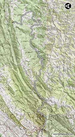
NOTE: The Topo Hike Trails Map.pdf">here does not contain a TOPO map. There are just way to may interconnectiong trails and and details to fit on one page. We highly reccomend that you purchase the National Geographic Mount Rogers 786 Map.
Also see the alternate 2 day version at the end of this write-up.
DAY 1 – 15.5 miles
- Mile 0.0 – Start at the Mount Rogers Outfitters Hostel and followed the white blazed Appalacian Trail (A.T.) through Damascus. The A.T. will bear off to the left just outside of town after you have been on the Virginia Creeper Trail for a little while. Stay on the Virginia Creeper Trail for the next 7.4 miles enjoying the many beautiful views of the creek and fields.
- Mile 7.4 – Taylor's Valley (Route 725). You will see the Creeper Trail Cafe on the right on the other side of the bridge. Continue 4.9 miles to the Creek Junction Trestle.
- Mile 12.3 – Cross the Creek Junction Trestle, the tallest trestle on the Virginia Creeper Trail. Bear to the left onto the A.T. after crossing the trestle, continue for 1.9 miles to the Lost Mountain Shelter. Take a look at the trestle construction, really cool.
- Mile 14.2 – Lost Mountain Shelter. Continue north to Route 58 crossing, Summit Cut, in 1.1 miles, this will be mostly down.
- Mile 15.3 – Route 58, Summit Cut. Fill up on water just before crossing Route 58. Campsite is in 0.2 miles after Route 58
- Mile 15.5 – Day 1 Campsite on left at pine grove, no water here. Walk in just a little ways for enough flat spots for 4-5 tents.
DAY 2 – 16.4 miles
Continue north from the campsite, going through fields, and reach the Route 601 Parking in 1.2 miles.
- Mile 16.7 – Route 601 Parking, room for 4-5 cars, gravel road. Coordinates: 36.6373 -81.6404. Be prepared for some exertion on the next 2.6 miles, gaining almost 1700' and not many switchbacks.
- Mile 19.3 – Reach Buzzard Rock (5096') after a nice steady climb up the side of Beech Mountain. There are some awesome views here. Go through a section of woods and quickly come out into the open again reaching a spring in 0.8 miles below Whitetop Mtn.
- Mile 20.1 – Spring. The next section is mostly in the woods and downhill to the Parking area on Route 600
- Mile 22.6 – Route 600 Parking, coordinates: 36.6465, -81.5832. Cross Route 600 and go through the gate into the open field, be sure to look back over your shoulder on occasion to view Whitetop Mtn. Continue the climb towards Mt Rogers Spur Trail, reaching it in 4 miles. This section is mostly in the woods until just before the spur trail. Some of these woods will make you think you are in Canada.
- Mile 26.6 – Mt Rogers Spur Trail, tallest Mountain in VA, 5729'. You are there, go to the summit but don't expect any views, the summit is covered with trees. Continue 0.2 miles to the Thomas Knob Shelter.
- Mile 26.8 – Thomas Knob Shelter. Great place for lunch and to fill up with water about 150 yards behind the shelter where there are also great views. The next 5.1 miles through Grayson Highlands have some of the best views you will find in Virginia. You may also be fortunate enough to see some of the wild ponies.
- Mile 31.0 – Quebec Branch creek crossing, could fill up here or at Big Wilson Creek near the shelter.
- Mile 31.9 – Wise Shelter. Plentiful campsites near the shelter. Water source is Big Wilson Creek, about 0.1 miles north on the AT from the shelter.
DAY 3 – 7.7 miles
Continue north on the AT from the campsite, through the Little Wilson Creek Wilderness, reaching the Scales Campgound in 3 miles. We hiked this early in the morning, great views even with clouds blowing through .
- Mile 34.9 – Scales Campgound. Clean pit toilets located here. You will be pretty much in the woods for the hike down to Route 603 parking area.
- Mile 37.9 – Old Orchard Shelter.
- Mile 39.6 – Route 603 parking area. Shuttle ride back to Damascus.
Alternate 2 Day Version – 24.3 miles
Day 1 – (11.5 miles) Skip the VA Creeper Trail and have the shuttle take you to Route 58 (Summit Cut). Hike to Thomas Knob Shelter and spend the night near there, tons of campsites just after the shelter.
Day 2 – (12.8 miles) Thomas Knob Shelter to Route 603 have shuttle pick you up around 3 or 4 depending on your pace