Loading...

🎉 Enjoy a Free 7-Day Supporter Trial and Unlock Exclusive Perks — No Credit Card Required. Learn more.

Mountain Top Arboretum Loop

Directions
Map
Pictures
Send to App
Distance:
0.4 Miles / 0.6 km
Type:
Loop
Difficulty:
Easy
Time to Hike:
~12 minutes
Surface Type:
Dirt
Park:
Mountain Top Arboretum
Town:
Tannersville, New York
Directions:
42.222196, -74.13317
Added:
September 11, 2023
Updated:
September 12, 2023
Copy Trail Link Hiking this trail? Send a friend or family member a link to this trail guide for your own safety. Hike at your own risk (disclaimer)
Loading...
Loading...
14'

Total Change
14'

Ascent
17'

Descent

Download the Trail Route for Offline Use

Supporters get exclusive access to download trail routes to the MyHikes app for offline use. Stay prepared on your adventure, even without an internet connection! Become a Supporter today to unlock this feature and hike with confidence.

Send to App

Mountain Top Arboretum Loop

The Mountain Top Arboretum Loop at Mountain Top Arboretum in Tannersville, New York is an easy 0.4-mile loop hike that features a pond, labyrinth, and a grove of Dawn Redwood trees.

Walk Description
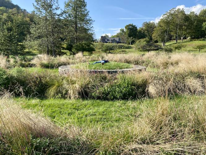
This is not a hike, but rather a short walk or stroll through the open meadows of the arboretum, located north of the main parking lot. This walk begins at the main entrance and first passes the small pond before heading over toward the gazebo that's built out of tree branches. Next, the track leads over through the evergreen plots to reach the labyrinth. Behind the labyrinth, on the hill in the background, is the scenic stone mountain top church labeled on Google Maps as "All Souls Church". Visitors can walk the labyrinth, but due to the keeping of plants and other shrubs, please follow the pathway.

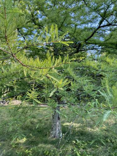
After the labyrinth, the track then heads south to reach a bedrock patch in the earth where there's an information kiosk about the bedrock, Dawn Redwood, and Bald Cypress trees growing on the property. Don't confuse the Dawn Redwood with the Bald Cypress, however, because both look similar.

The track then follows the pond back to the beginning as it follows under a row of, what looked like, Bald Cypress trees.

Parking
Walkers will find parking at the coordinates provided, the lot is large enough to fit about a dozen vehicles.

Pets
Dogs are not allowed in this section of the park. Please see the park map for more details about where dogs are permitted - as of September, 2023.
Explore 13 trails near Tannersville, NY
  1. Parking

    42.222196, -74.13317
  2. Main Trailhead

    42.222213, -74.133586
  3. Labyrinth

    42.223153, -74.132842
    Labyrinth
  4. Dawn Redwood trees

    42.222431, -74.132819
    Dawn Redwood trees
No community routes found. To add your own hike as a Community Route for this Trail guide, leave a Trip Report with an attached GPX file.

Hazards

Ticks - Lyme Disease More Info (CDC)

Seasons

All

Weather Forecast

In Tannersville, NY

Explore Hiking Trails

You May Also Like

Colorado's Million Dollar Highway - Plan a day's drive adventure along the iconic Million Dollar Highway in Colorado. Explore the best short trails, roadside stops, waterfalls, vistas, ghost towns, and hot springs within a ~6 hour road trip.
Explore

Colorado's Million Dollar Highway

Plan a day's drive adventure along the iconic Million Dollar Highway in Colorado. Explore the best short trails, roadside stops, waterfalls, vistas, ghost towns, and hot springs within a ~6 hour road trip.

Read
Glacier's Going-to-the-Sun Road - Discover the breathtaking beauty of Glacier National Park along the iconic Going-to-the-Sun Road. From stunning roadside stops to picturesque waterfalls and vistas, this engineering marvel offers endless opportunities for exploration.
Explore

Glacier's Going-to-the-Sun Road

Discover the breathtaking beauty of Glacier National Park along the iconic Going-to-the-Sun Road. From stunning roadside stops to picturesque waterfalls and vistas, this engineering marvel offers endless opportunities for exploration.

Read
New York's Best Waterfalls - Whether you're planning a day hike, roadside stop, or a leisurely short walk, this guide provides hikers, travelers, and locals alike with 63 different locations to over 100 scenic waterfalls to help plan your next adventure!
Explore

New York's Best Waterfalls

Whether you're planning a day hike, roadside stop, or a leisurely short walk, this guide provides hikers, travelers, and locals alike with 63 different locations to over 100 scenic waterfalls to help plan your next adventure!

Read

Before you boogie...

Find our trail guides useful? Consider becoming a Supporter to unlock perks!

MyHikes is an indie platform that makes exploring public trails easier for everyone. The platform has no investors, no ads, and is owned and operated by one person, Dave Miller. Dave has personally mapped and written over 1,800 trail guides on MyHikes for the public to explore. MyHikes has helped millions outdoor enthusiasts plan their next adventure.

But it takes a lot of time 🕦, money 💰, work, and espresso shots ☕ to run MyHikes, including hiking , mapping , writing , and publishing new trails with high-quality (accurate) information... along with software engineering (coding) the platform like building new features, website and mobile app development (iOS and Android), site maintainance . and much much more.

Supporters unlock website and mobile app perks with an annual one-time payment of $25 (you renew) 😎👍. Or you can simply make a Donation of your choice. Otherwise, you can support us by telling your friends about MyHikes - both quick and free 🎉

Admin user profile picture

Dave Miller
MyHikes Founder