Located in the Eastern Divide Ranger District of Jefferson National Forest, the Mountain Lake Wilderness is the largest wilderness entity in Virginia outside of Shenandoah National Park. The wilderness gets its name from Mountain Lake, the only naturally occurring mountain lake in Virginia and all of the southern Appalachian Mountains. However, the wilderness itself is located along the ridges and mountains above the lake and the Mountain Lake Conservancy property. Situated among 4,000 foot ridgelines of the Allegheny Mountains in northern Giles County, this wilderness features multiple outstanding viewpoints and unique upland bogs. Starting at the southern end of the wilderness you will travel through bogs mixed with saplings and grasses on the way to War Spur Overlook before heading north to connect with the Appalachian Trail. While on the AT you’ll pass by more upland bogs and an old-growth red spruce bog as a prelude for the expansive views from Wind Rock. There are many possible campsites along the Potts Mountain Trail, or you can call it a day by completing the loop. This is one of those rare hikes where the forest is just as interesting as the views.
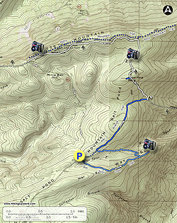
- Mile 0.0 – The War Spur Loop Trail [68] (no blaze) begins near the information board. Take the right/south portion of the loop as it passes through hardwood forests with a lush understory of ferns. (Note – the southern portion of the loop trail is sometimes called the Chestnut Trail.) The first portion of the hike follows the contours of Salt Pond Mountain around 3,700 feet and contains multiple upland bogs mixed with drier ground full of grasses and saplings. You’ll cross the origin of War Spur Branch as soon as you begin the hike.
- Mile 1.1 – Continue straight through a T-junction with the loop following the side trail to the War Spur Overlook.
- Mile 1.3 – The trail ends at War Spur Overlook. From this rock outcrop you’ll have views north of Lone Pine Peak on Salt Pond Mountain and northeast of the War Spur Branch basin below Johns Creek Mountain.
- Mile 1.6 – At the T-junction turn right on the northern section of the War Spur Loop Trail. The trail descends to War Spur Branch through dark rhododendron tunnels.
- Mile 2.4 – Turn right at a T-junction following the War Branch Trail [69] (no blaze) north. (Note – this trail is sometimes named the War Spur Connector Trail.) You’ll follow what seems to be a former logging road.
- Mile 3.7 – The trail ends at a T-junction with the Appalachian Trail (white blaze). There are flat areas for campsites around this intersection, and water close to the War Branch Trail above. (Camping Option - turn right heading north on the AT (compass east) to camp at the War Spur Hut.) Turn left following the AT south. (You will be heading compass north in this section.) This is the steepest climb of the hike towards the summit of Lone Pine Peak.
- Mile 4.2 – The AT passes beside the summit of Lone Pine Peak (4,054 feet). It is a few hundred feet from the trail if you want to tag the summit. The mountaintop is littered with large, exposed slabs of colorful Tuscarora sandstone.
- Mile 4.6 – On both sides of the trail are upland bogs with chest-height ferns.
- Mile 5.1 – The AT curves left heading west. At this junction a faint trail continues straight/north to connect with the Potts Mountain Trail. The Potts Mountain Trail is overgrown in sections but has multiple options for camping. If you are heading out to see the views from White Rocks take this connector trail. For the next 1.7 miles the AT heads west with grass and fern understory lining the trail and patches of red spruce bog on your left. The contrast between the trees and ferns in this section is stunning.
- Mile 6.8 – Cross intersection beside campsites with the overgrown Potts Mountain Trail on the right, the Appalachian Trail and Potts Mountain Trail continuing left, and Wind Rock straight ahead.
- Mile 6.9 – Emerge from the canopy onto Wind Rock. Wind Rock at 4,120 feet sits on Potts Mountain near the Eastern Continental Divide and the West Virginia border. From this lofty perch you have expansive views south, west, and north. To the south the tall ridges of Big Mountain and Butt Mountain tower above the Little Stony Creek headwaters. The long ridge encompassing the western view is Peters Mountain, defining the Virginia/West Virginia border. To the northwest is the beautiful, remote valley of Potts Creek between Peters Mountain and Potts Mountain. Return to the trail intersection and turn right following the Appalachian Trail.
- Mile 7.1 – Y-junction with a forest road on the right. Both trails lead to the same parking area on VA 613.
- Mile 7.2 – The Appalachian Trail crosses VA 613 at the parking lot for Wind Rock. Turn left heading south on VA 613.
- Mile 7.6 – Pass by a plaque commemorating Minie Ball Hill, the spot where Union General George Crook abandoned many supplies after retreating from the Battle of Cloyds’ Mountain.
- Mile 8.8 – Hike ends at the War Spur Loop Trail parking lot.