The Mount Royal Traverse at Mount Royal Park in Montréal, Quebec is a moderate 4.75 km one-way hike that leads to Beaver Lake, Beaver Lake Falls, a panoramic view of the city from the Kondiaronk Belvedere overlook, Mount Royal Cross, Mount Royal Summit, and more city views from the Camilien-Houde Belvedere overlook.
After exploring Beaver Lake and Beaver Falls, the route heads east toward the Kondiaronk Belvedere overlook and crosses Chemin Olmsted road to follow an unnamed forest trail. This forest trail, as of October 2024, was partially closed, so this route followed the detour north to hop on Boucle du Sommet.Panoramic City Views from Kondiaronk Belvedere - 2.55 km
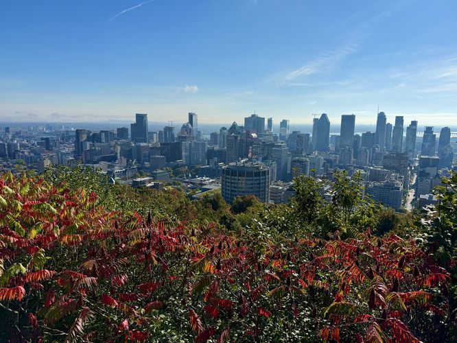
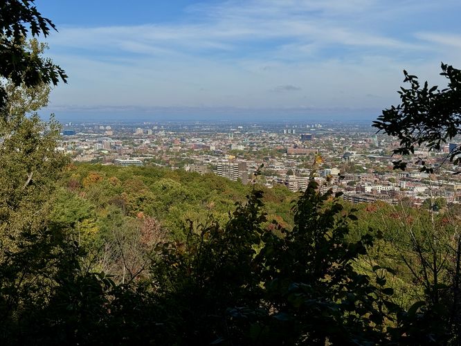
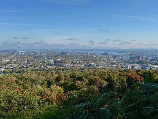
Once on Boucle du Sommet, the route leads past the stunning architecture of the Mount Royal Chalet and out to the panoramic views from the Kondiaronk Belvedere overlook. The Kondiaronk Belvedere overlook provides 180-degree views of downtown Montréal. This extremely-popular overlook will most-likely have people when you visit, unless you show up at sunrise.
After exploring the summit, this route heads northwest and crosses Boucle du Sommet once more before the trail leads down a series of stairs. The stairs, which lead to the Camilien-Houde Belvedere overlook, have ornate decor and provide several northeast-facing city views.
Parking & Fees
Hikers will find several parking locations, but the coordinates provided will bring you to the top of Mount Royal to its main parking lot near Beaver Lake. As of October 2024, there's a $15 parking fee. We, however, took an Uber to the parking lot which cost a similar amount of money.
Hiking Mount Royal
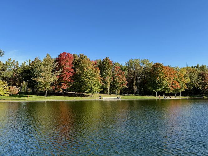
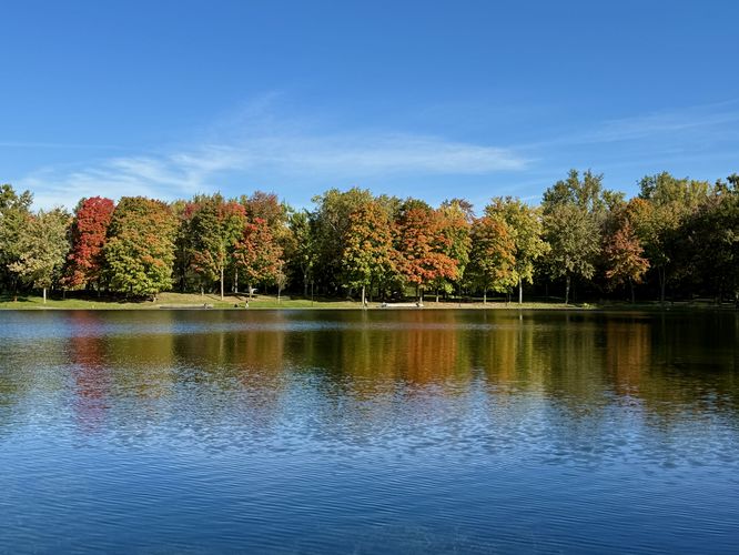
This hike begins at the main parking lot atop Mount Royal and follows a universally-accessible path southwest that connects the parking lot to Beaver Lake (Lac aux Castors). At Beaver Lake, the route leads hikers around the water's edge where you'll find scenic views of the water. During autumn, the foliage changing in the leaves reflects off of the water and adds to the scenery.Beaver Lake Falls / Fountain - 0.8
Hikers will reach the east side of Beaver Lake where they'll find the human-made waterfall (or fountain), Beaver Falls, cascading down the neatly-placed bedrock. This fountain flows directly into Beaver Lake but despite it being human-made, it's one of the more scenic stops along this route.After exploring Beaver Lake and Beaver Falls, the route heads east toward the Kondiaronk Belvedere overlook and crosses Chemin Olmsted road to follow an unnamed forest trail. This forest trail, as of October 2024, was partially closed, so this route followed the detour north to hop on Boucle du Sommet.
Panoramic City Views from Kondiaronk Belvedere - 2.55 km
Once on Boucle du Sommet, the route leads past the stunning architecture of the Mount Royal Chalet and out to the panoramic views from the Kondiaronk Belvedere overlook. The Kondiaronk Belvedere overlook provides 180-degree views of downtown Montréal. This extremely-popular overlook will most-likely have people when you visit, unless you show up at sunrise. Hiking to Mount Royal Cross - 2.55 to 3.4 km
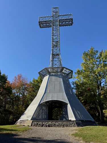
The hike from the Kondiaronk Belvedere overlook to the Mount Royal Cross is fairly straight forward -- head to the road behind the Mount Royal Chalet (Boucle du Sommet) and follow the universally-accessible path as it runs along the top of the mountain out toward the cross. Pay attention to your placement on the map to find a left-hand turn around 3.35 km which leads up a short hill to reach the Mount Royal Cross. The cross is taller than 10 meters and hikers can walk through the base of it. Whether or not you're religious, this metal structure is another interesting point-of-interest atop Mount Royal.Mount Royal Summit - 3.6 km
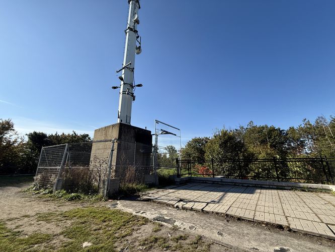
Just west of the Mount Royal Cross lies the summit of Mount Royal. This route leads directly to the summit by following a connector trail to the west of the cross. The summit has nothing interesting to see, unfortunately. As of October 2024, there's a radio tower, but seemingly no summit marker or survey marker. Without any views, the upside is the summit is generally quiet with no people around.After exploring the summit, this route heads northwest and crosses Boucle du Sommet once more before the trail leads down a series of stairs. The stairs, which lead to the Camilien-Houde Belvedere overlook, have ornate decor and provide several northeast-facing city views.