The Mount Pisgah Loop at Mount Pisgah County Park near Troy, Pennsylvania is a moderate 1.3-mile loop hike that features several stunning views from the summit of Mount Pisgah.
Trails
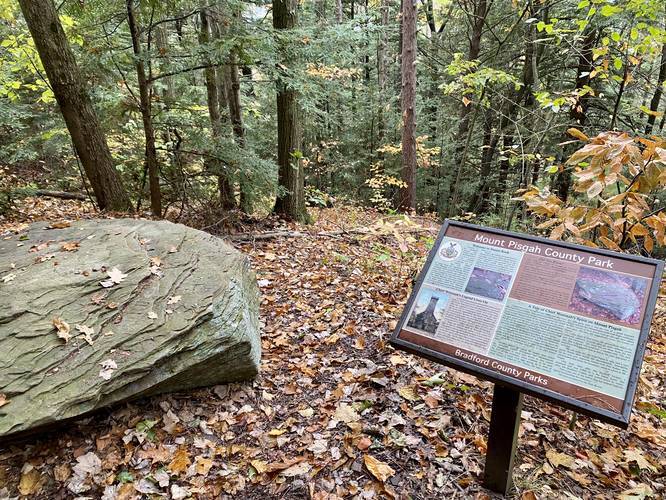
This hike follows several unnamed trails within the park and a portion of a named trail, the Wetona Trail. Unfortunately, as of October 2020, this county park does not have a very accurate trail map. There are two proposed trail map signs at the main parking area at the summit; however, the planned trail maps do not match the existing trails. There's an additional wooden trail map located in the pavilion that depicts 3 named trails, but it's not easy figuring out exactly where these trails start or end.
Hike Description
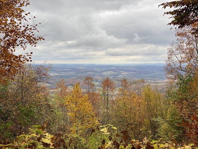
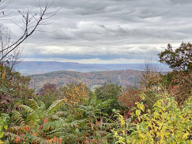
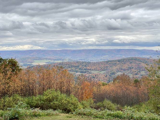
This track begins at the main parking lot and heads out to the main summit vista atop Mount Pisgah. From the main lookout, hikers get a view of Troy, PA, Oak Hill, Armenia Mountain, and a sliver of Tioga County.
After stopping at the vista, this hike takes a right-hand turn to head toward a rock called "Sunset Rock" - follow the signs posted on the trees to reach Sunset Rock.
Sunset Rock
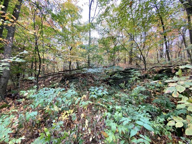
Despite the name, Sunset Rock is a 3-foot wide mostly-flat rock that sits along the trail around mile 0.1. Hikers cannot miss it since there's an interpretive sign located next to it. Sunset Rock was once a place for meditation for the legendary Oneida Chief Wetonah. It's said that Wetonah used to roam the Mount Pisgah area more than two hundred years ago. Wetonah had a strong appreciation for the natural world around him and what it offered to sustain life. Sunset Rock was a place Wetonah used to frequent to meditate and overlook the scenic valleys below. Today there's no overlook at Sunset Rock unfortunately, but hikers can find carvings in the rock that show how many visitors have come here prior.
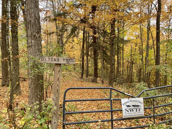
Continuing onward from Sunset Rock, the trail will perform a horseshoe-like pattern in the mountainside. Hikers should stay to the right at most of the trail junctions to stay along the main route. Eventually, the trail meets up with a metal gate with a trailhead sign labeled "Wetona" - as you just hiked a small portion of the Wetona Trail.
2nd Vista / Overlook
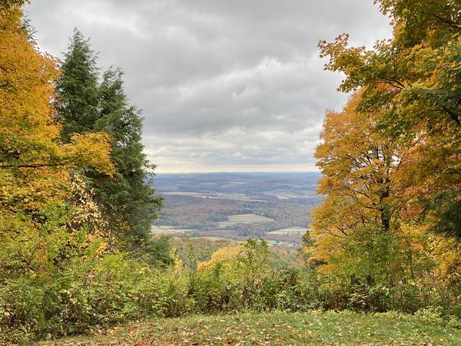
Just after the metal gate, about 100 to 200-feet down the trail, is another overlook hikers can stop at to take in views of the valleys below.
From here, the trail technically heads into the woods and runs alongside the road, but as of October 2020, that section of trail was difficult to see, so we hopped on the road and hiked down the mountain to the 3rd vista / overlook.
3rd Vista / Overlook
After hiking down the mountain from the 2nd overlook, hikers will notice a 3rd overlook to stop at to take in more views.
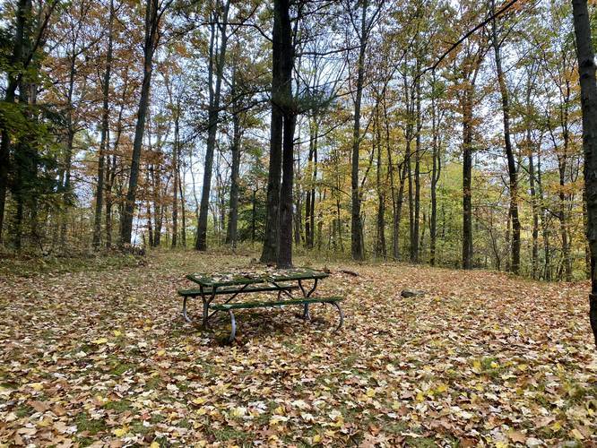
From the 3rd overlook, the trail heads downhill for about 0.1-miles as it passes an old cabin foundation on the right-hand side. Just after the cabin foundation, the trail will take a sharp right-hand turn to head back up toward the main road. Here, our track takes an additional short right-hand turn before the road to find a picnic table.
At the road crossing, this track heads down the southern campsite road, passing several campsites before reaching the 4th and final vista / overlook.
4th Vista / Overlook
Around mile 1.2, hikers will reach the 4th overlook, which is the final vista along this hike - discounting the 1st vista you'll pass before reaching parking. Here, campsites can be found along this dirt road as well.
From the 4th vista, the hike to parking is easy. Head down the campsite road to find a fork in the trail. Head straight, skipping both right-hand and left-hand turns here. This short trail leads uphill to the 1st vista next to the parking area which completes the hike for approximately 1.3-miles.
Parking
Hikers will find parking near the coordinates provided. The lot is large enough to fit about 10 vehicles. Additional parking can be found just below the summit parking area as well.
Camping
While backpacking is not permitted at Mount Pisgah County Park, campers can pay $10 per night to setup camp at the designated campsites at the park. This trail passes several campsites - most of the sites are spread apart so folks have privacy. Unsure of where to pay for camping, but there's likely a self-serve station along the campsite entrance road.
Pets
Dogs are allowed if leashed.
Difficulty
This hike is considered moderate because of the needless elevation gain along the loop. Due to the lack of blazes and proper trail maps, this hike could be easier.
Trails
This hike follows several unnamed trails within the park and a portion of a named trail, the Wetona Trail. Unfortunately, as of October 2020, this county park does not have a very accurate trail map. There are two proposed trail map signs at the main parking area at the summit; however, the planned trail maps do not match the existing trails. There's an additional wooden trail map located in the pavilion that depicts 3 named trails, but it's not easy figuring out exactly where these trails start or end.
Hike Description
This track begins at the main parking lot and heads out to the main summit vista atop Mount Pisgah. From the main lookout, hikers get a view of Troy, PA, Oak Hill, Armenia Mountain, and a sliver of Tioga County.
After stopping at the vista, this hike takes a right-hand turn to head toward a rock called "Sunset Rock" - follow the signs posted on the trees to reach Sunset Rock.
Sunset Rock
Despite the name, Sunset Rock is a 3-foot wide mostly-flat rock that sits along the trail around mile 0.1. Hikers cannot miss it since there's an interpretive sign located next to it. Sunset Rock was once a place for meditation for the legendary Oneida Chief Wetonah. It's said that Wetonah used to roam the Mount Pisgah area more than two hundred years ago. Wetonah had a strong appreciation for the natural world around him and what it offered to sustain life. Sunset Rock was a place Wetonah used to frequent to meditate and overlook the scenic valleys below. Today there's no overlook at Sunset Rock unfortunately, but hikers can find carvings in the rock that show how many visitors have come here prior.
Continuing onward from Sunset Rock, the trail will perform a horseshoe-like pattern in the mountainside. Hikers should stay to the right at most of the trail junctions to stay along the main route. Eventually, the trail meets up with a metal gate with a trailhead sign labeled "Wetona" - as you just hiked a small portion of the Wetona Trail.
2nd Vista / Overlook
Just after the metal gate, about 100 to 200-feet down the trail, is another overlook hikers can stop at to take in views of the valleys below.
From here, the trail technically heads into the woods and runs alongside the road, but as of October 2020, that section of trail was difficult to see, so we hopped on the road and hiked down the mountain to the 3rd vista / overlook.
3rd Vista / Overlook
After hiking down the mountain from the 2nd overlook, hikers will notice a 3rd overlook to stop at to take in more views.
From the 3rd overlook, the trail heads downhill for about 0.1-miles as it passes an old cabin foundation on the right-hand side. Just after the cabin foundation, the trail will take a sharp right-hand turn to head back up toward the main road. Here, our track takes an additional short right-hand turn before the road to find a picnic table.
At the road crossing, this track heads down the southern campsite road, passing several campsites before reaching the 4th and final vista / overlook.
4th Vista / Overlook
Around mile 1.2, hikers will reach the 4th overlook, which is the final vista along this hike - discounting the 1st vista you'll pass before reaching parking. Here, campsites can be found along this dirt road as well.
From the 4th vista, the hike to parking is easy. Head down the campsite road to find a fork in the trail. Head straight, skipping both right-hand and left-hand turns here. This short trail leads uphill to the 1st vista next to the parking area which completes the hike for approximately 1.3-miles.
Parking
Hikers will find parking near the coordinates provided. The lot is large enough to fit about 10 vehicles. Additional parking can be found just below the summit parking area as well.
Camping
While backpacking is not permitted at Mount Pisgah County Park, campers can pay $10 per night to setup camp at the designated campsites at the park. This trail passes several campsites - most of the sites are spread apart so folks have privacy. Unsure of where to pay for camping, but there's likely a self-serve station along the campsite entrance road.
Pets
Dogs are allowed if leashed.
Difficulty
This hike is considered moderate because of the needless elevation gain along the loop. Due to the lack of blazes and proper trail maps, this hike could be easier.