Loading...

๐ŸŽ‰ Enjoy a Free 7-Day Supporter Trial and Unlock Exclusive Perks โ€” No Credit Card Required. Learn more.

Mount Chocorua via Piper Trail

Directions
Map
Pictures
Send to App
Distance:
8.1 Miles / 13.0 km
Type:
Out-and-Back
Difficulty:
Hard
Time to Hike:
4 hours, ~5 minutes
Features:
Surface Type:
Dirt
Park:
White Mountain National Forest
Town:
Albany, New Hampshire
Directions:
43.940329, -71.228609
Added:
May 27, 2019
Updated:
May 28, 2019
Copy Trail Link Hiking this trail? Send a friend or family member a link to this trail guide for your own safety. Hike at your own risk (disclaimer)
Loading...
Loading...
2,868'

Total Change
2,943'

Ascent
2,916'

Descent

Download the Trail Route for Offline Use

Supporters get exclusive access to download trail routes to the MyHikes app for offline use. Stay prepared on your adventure, even without an internet connection! Become a Supporter today to unlock this feature and hike with confidence.

Send to App

Mount Chocorua via Piper Trail

The Mount Chocorua via Piper Trail at the White Mountain National Forest in Albany, New Hampshire is a difficult 8.1-mile out-and-back hike that takes you up the southern side of Mount Chocorua to the summit.

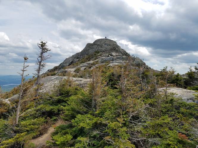
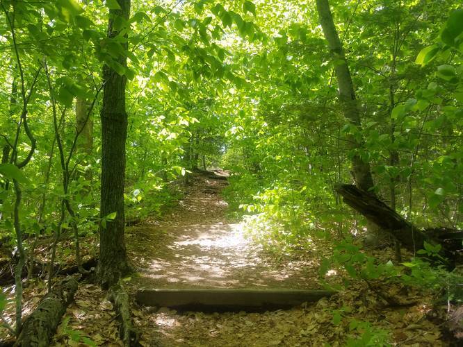
The first few miles are a fairly easy grade on a well maintained and easy to follow trail. The last 2-miles or so travel up rocky stairways and large, flat stone slopes. The trail gets trickier to follow as you get closer to the top, but keep your eyes out for the yellow blazes and you'll do fine.

Fee: The fee to park at the trailhead is $5, cash only.

Pets: Leashed dogs are allowed.

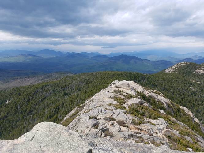
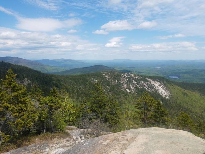
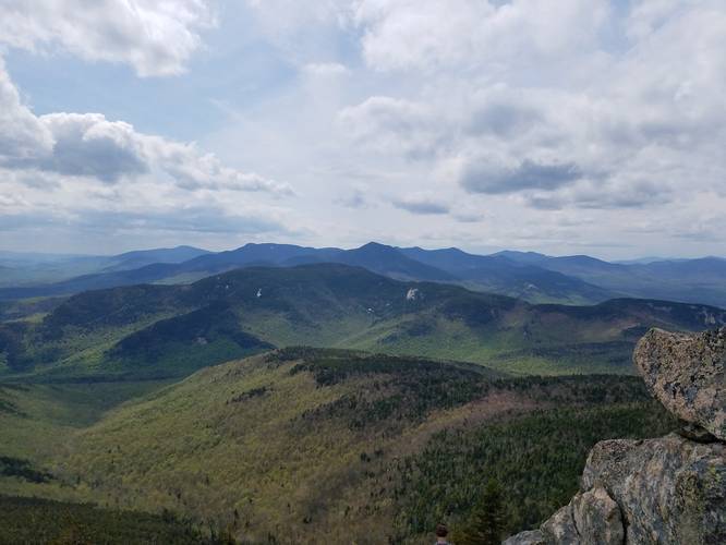
Elevation Gain: Over 2,900-feet. There were lots of kids and families at the summit, but this trail won't be for everyone. Bring plenty of water and some food to enjoy at the top. The 360 views will be plenty worth it.

Buggy: There were a good amount of bugs on the trail at the lower parts, so bug spray is highly recommended.
Explore 19 trails near Albany, NH
  1. Parking

    43.940329, -71.228609
  2. Main Trailhead

    43.940344, -71.229085
  3. View from Mount Chocorua's summit

    43.95433, -71.273175
    View from Mount Chocorua's summit
  4. Just below Mount Chocorua's summit

    43.955565, -71.273557
    Just below Mount Chocorua's summit
  5. Hiking under the treeline on the way up Mount Chocorua

    43.945203, -71.237683
    Hiking under the treeline on the way up Mount Chocorua
  6. Vista along the trail on the hike up Mount Chocorua

    43.959419, -71.264896
    Vista along the trail on the hike up Mount Chocorua
  7. View from Mount Chocorua's summit

    43.95419, -71.273402
    View from Mount Chocorua's summit
No community routes found. To add your own hike as a Community Route for this Trail guide, leave a Trip Report with an attached GPX file.

Hazards

Ticks - Lyme Disease More Info (CDC)

Seasons

All

Blaze Color

Yellow

Trip Reports

Trail Guide By:
nikkiseeseverything user profile picture
8.1 miles / 13.0 km

Weather Forecast

In Albany, NH

Explore Hiking Trails

You May Also Like

Colorado's Million Dollar Highway - Plan a day's drive adventure along the iconic Million Dollar Highway in Colorado. Explore the best short trails, roadside stops, waterfalls, vistas, ghost towns, and hot springs within a ~6 hour road trip.
Explore

Colorado's Million Dollar Highway

Plan a day's drive adventure along the iconic Million Dollar Highway in Colorado. Explore the best short trails, roadside stops, waterfalls, vistas, ghost towns, and hot springs within a ~6 hour road trip.

Read
Glacier's Going-to-the-Sun Road - Discover the breathtaking beauty of Glacier National Park along the iconic Going-to-the-Sun Road. From stunning roadside stops to picturesque waterfalls and vistas, this engineering marvel offers endless opportunities for exploration.
Explore

Glacier's Going-to-the-Sun Road

Discover the breathtaking beauty of Glacier National Park along the iconic Going-to-the-Sun Road. From stunning roadside stops to picturesque waterfalls and vistas, this engineering marvel offers endless opportunities for exploration.

Read
New York's Best Waterfalls - Whether you're planning a day hike, roadside stop, or a leisurely short walk, this guide provides hikers, travelers, and locals alike with 63 different locations to over 100 scenic waterfalls to help plan your next adventure!
Explore

New York's Best Waterfalls

Whether you're planning a day hike, roadside stop, or a leisurely short walk, this guide provides hikers, travelers, and locals alike with 63 different locations to over 100 scenic waterfalls to help plan your next adventure!

Read

Before you boogie...

Find our trail guides useful? Consider becoming a Supporter to unlock perks!

MyHikes is an indie platform that makes exploring public trails easier for everyone. The platform has no investors, no ads, and is owned and operated by one person, Dave Miller. Dave has personally mapped and written over 1,800 trail guides on MyHikes for the public to explore. MyHikes has helped millions outdoor enthusiasts plan their next adventure.

But it takes a lot of time ๐Ÿ•ฆ, money ๐Ÿ’ฐ, work, and espresso shots โ˜• to run MyHikes, including hiking , mapping , writing , and publishing new trails with high-quality (accurate) information... along with software engineering (coding) the platform like building new features, website and mobile app development (iOS and Android), site maintainance . and much much more.

Supporters unlock website and mobile app perks with an annual one-time payment of $25 (you renew) ๐Ÿ˜Ž๐Ÿ‘. Or you can simply make a Donation of your choice. Otherwise, you can support us by telling your friends about MyHikes - both quick and free ๐ŸŽ‰

Admin user profile picture

Dave Miller
MyHikes Founder