A 33 mile trek across subalpine meadows, wildflowers, lakes, and glacial basins on the northwest slope of Mount Adams. Most of the hike is either at treeline or above, so views of Mount Adams, Mount Rainier, Mount St. Helens, the Goat Rocks, and various other peaks are almost always in view.
Note: Crystal Lake, the meadow-route to High Camp, and the off trail route to Glacier Lake above High Camp are not recommended if you are inexperienced with off-trail hiking, especially the latter route. But you can camp at Riley Camp Meadow, Riley Creek along the PCT, or Sheep Lake instead of Crystal Lake. You can still complete the hike without making the trek to Crystal Lake by turning left (northbound) on the PCT instead of south (unless you want to hike a short ways southbound to camp at Riley Creek (beautiful sites) or Sheep Lake.
Section A: Riley Camp Trail to Crystal Lake
Start out on the Riley Camp Trail #64 and begin climbing up through a fairly lush montane forest of silver fir, lodgepole pine, and hemlocks.
Follow the trail, passing the junction for the Riley South/Riley Spur Trail #64A. Continue on the Riley Camp Trail. After some switchbacks, you will enter a previous burn from the 2015 Mount Adams Complex Fires that burned around Island Lake and several other unnamed lakes.
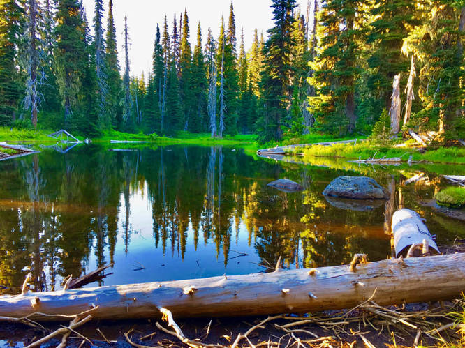
Pass by a small lake before exiting the burn and passing by a few pretty small ponds. Soon you will get to Riley Meadow, where a breathtaking view of Mount Adams presides over the meadow. Riley Camp at the meadow is your first camping option.
From here, the trail crosses Riley Creek and leads you up through a mixed subalpine and montane forest before reaching the junction with the Pacific Crest Trail (PCT) #2000. Turn right onto the PCT and hike through subalpine wildflower parklands full of heather, lupine, and indian paintbrush interspersed with mountain hemlock and subalpine fir.
Cross Riley Creek again (some great creek-side campsites), pass by Sheep Lake (spacious campsites), and ascend up to a saddle between Burnt Rock and Mount Adams. This saddle is the beginning of the ridgewalk off-trail hike up to Crystal Lake. Follow the ridgeline, staying close to the spine as best as you can. Soon, come to a steep rock/talus slope and a "pass." Instead of climbing up through the rocky slope at the middle, look to the right (south) side and look for a trail heading up the south arm of the ridge. The trail takes you to the top.
No campfires allowed above the Pacific Crest Trail, Round the Mountain Trail, or Highline Trails.
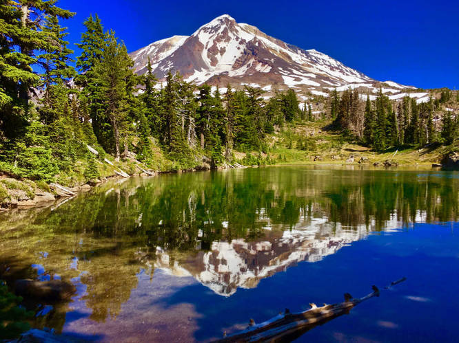
Follow the path of least resistance along an open meadow area, following a faint trail through the meadow. The trail will veer to the left abruptly, before topping out at Crystal Lake. The lake offers some of the best views and reflections on the entire mountain. Because the lake is located smack dab on top of a ridgeline, views of the mountain are unobstructed. Follow the path on the north end of the lake to get to a spectacular viewpoint over the Riley Creek basin, with views of Mount Adams, St. Helens, and Mount Rainier. This area is very fragile and the lake is small, so be very kind to this area! No campfires allowed here, or face a hefty fine! If possible, camp below at either Sheep Lake or Riley Creek and make Crystal Lake a day-hike. The lake is special and one of a kind on Mount Adams, so treat it with the utmost respect.
Section B: Crystal Lake to Divide Meadow/Divide Camp
Hike back the way you came. Once back on the PCT, head back the way you came past Sheep Lake and Riley Creek. Once at the Riley Camp Trail #64 junction, continue north on the PCT.
The PCT starts to duck back into thicker old growth forests. Take in the beauty of the giant trees and keep an eye out for interesting rock formations. The trail carves its way across the Mutton Creek Lava Flow before crossing Mutton Creek. Continue along the trail, crossing the Lewis River (read:creek), before reaching an unnamed spur trail to your left. You can check out the viewpoint at the end of this short trail to look out across to Mount Rainier, the Midway High Lakes area, and the Cispus River valley far below you.
Back on the PCT, reach the junction with the Divide Camp Trail and make the optional short 0.8 mile detour down to Divide Meadow, where a spectacular view of Mount Adams looms above the wildflower-covered meadow below. You will be inundated with wildflowers in season (usually late July or early August is prime season for flowers here). There is a spur trail to the west leading to Divide Camp, a nice and spacious backcountry camp (one site).
Section C: Divide Meadow to High Camp and Glacier Lake
Hike back up the Divide Camp Trail to rejoin the PCT and turn left (northbound on the PCT). The trail will cross a vast rock and glacial debris basin, formed by the ever-changing paths of powerful and glacial-fed Adams Creek. Reach a fairly challenging crossing of Adams Creek (usually has small wood branches or logs to aid in crossing), and continue along the PCT on the other side.
It is 0.5 miles back from the junction with the Divide Camp Trail to the point on the PCT where you need to hike off trail. (If you don't want to do off-trail hiking, you can use the High Camp Trail #10 further down the trail to get to High Camp).
Find a clearing here just after it passes a large bend on the trail. Hike up through meadows and thin forests. You will need to step over logs and brush but it never gets too difficult. Use your GPS to stay in a general direction towards High Camp, following the path of least resistance most of the time. These meadows here feature some of the best wildflower displays on the mountain. Soon exit the wildflower parklands and enter a world of rock, talus, snow, and alpine tundra. Ascend a steep bank to reach High Camp. Walk across High Camp to reach the official High Camp Trail #10. You can camp at the various campsites here, but be considerate of the fragile alpine plants that takes years to heal from too many footsteps. High Camp is a spectacular alpine rock garden basin at the base of Adams Glacier and Mount Adams. On one side, the mountain looms so close it feels as if you could touch it. Looking back, a wide panorama of mountains and forested valleys spreads out below to the north, northeast, and west. Mount Rainier, Mount St. Helens, the Goat Rocks, the peaks of the Dark Divide, the Cispus River valley, and the Midway High Lakes can be seen far below.
From High Camp, hike up along a ridgeline to the east of camp to get to Glacier Lake, a spectacular lake at the very foot of Adams Glacier. The eastern lobe of the glacier reaches right down to the water's edge. To get to the lake, hike along the wide open ridge across alpine tundra and alpine rock gardens. Just before you reach the lake, you will pass through a large boulder field (pretty straight forward and not challenging). The lake features some campsites protected by rock wind breaks, but keep in mind to camp here you will need to purchase a Cascade Volcano Pass at the Trout Lake Ranger Station for the Mount Adams Ranger District. Keep in mind it is very exposed here and nearly devoid of plant life.
Section D: Glacier Lake and High Camp to Muddy Meadows Trailhead
After soaking in the views, hike down from Glacier Lake to re-join with the High Camp Trail #10. Hike down this trail to meet up with the PCT again. The High Camp Trail is much steeper and rutted out than the off-trail route, making this trail better for hiking downhill than uphill in my opinion. It also doesn't feature any views of Mount Adams, but has great views looking north to Mount Rainier and the Goat Rocks, which will be in constant view if you come down this trail rathern than up. Be cautious around the section right below High Camp, which crosses a steep and slipper talus slope. The trail here is very narrow, slippery, and hasn't seen much maintenance (if any) between my two trips in 2013 and 2016.
The High Camp Trail ends at a 4-way junction with the Killen Creek Trail #113 and the PCT. Turn right (northbound) on the PCT. Hike across verdant wildflower meadows and parklands before descending down into Killen Creek Meadows. In season, this stretch of trail is absolutely covered in purple lupines and red indian paintbrush flowers. The meadow has a few lakes and numerous campsites. This is the largest backcountry camping area in the wilderness.
Note: To severely shorten your trip, you can take the Killen Creek Trail #113 to meet up with the Killen Creek Trailhead. It is approximately 3 miles down to the trailhead. But in doing this, you will miss out on scenery at Killen Creek Meadows and Muddy Meadows.
Cross over Killen Creek above a 70-foot waterfall and look for a side trail leading down to the left down to a campsite below the falls. Follow this trail, crossing Killen Creek twice more, and follow the creek for a ways down. On any branching trails, stick to the left. Reach a spectacular oval-shaped blue lake, featuring a perfect view of Mount Rainier over the lake. Take the trail to the left and hike along the lake's west perimeter. On the other end, look back to Mount Adams as it casts a perfect reflection into the lake. From here, you can either hike cross country to meet back up with the PCT or hike back the way you came. (My advice is hike back the way you came, but if you want to make the shortcut, you can look for a very faint path on the north end of the lake about a hundred feet away, and hike east across a wildflower meadow. The path eventually fades out, but keep a bee-line for the PCT. This is part of an old abandoned trail.)
Turn left onto the PCT, and pass the junction with the Highline Trail #114. You can extend the trip by several miles if you take the Highline Trail and join up with the Muddy Meadows Trail #13.
The PCT from Killen Creek meadows heads downhill increasingly through a drier montane forestconsisting mostly of lodgepole pine. The wildflower meadows continue for a short way past Killen Creek Meadow before petering out.
Reach the 4-way junction with the Muddy Meadows Trail #13 and turn left, heading downhill. The trail heads down the mountain, with a few well placed switchbacks at some places. Eventually the trail enters a large grassy meadow called Muddy Meadows, where a spectacular view of Mount Adams presides over the meadow. Contrary to its name, this meadow is a spectacular meadow and worthy of a hike destination on its own. At the far end of the meadow, reach the Muddy Meaows Trailhead (one possible endpoint of your hike).
Section E: Muddy Meadows Trailhead to Killen Creek Trailhead
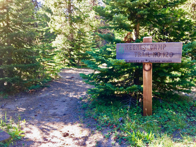
At the left/west side of the parking lot, look for a trail and hike down it as it follows alongside the lush swamplands of South Fork Spring Creek, the outlet for Muddy Meadows. Reach the junction with Road 2329 and cross over to meet up with the continuation of the trail, now marked as Keenes Camp Trail #120. A short two hundred feet later, it reaches another road, which is the camp road for Keenes Horse Camp.
Note: The GPS track shows an error I made when hiking down. I took the High Lakes Trail which follows Spring Creek all the while looking for the Killen Connector Trail. Don't do what I did, but continue down the campground road to find the correct trail. Up until I hiked this trail, all previous maps for Trail #113A had the trail alignment placed incorrectly. It has since been fixed on the Green Trails Maps.
Turn right onto the road and walk down to the other end of the campground. Look for a trail just before the junction with Road 2329 signed as Killen Creek Connector Trail #113A and turn right onto the trail. Hike along the trail before reaching Road 2329 again. Turn right and walk south down the road a short ways before rejoining the Killen Creek Connector Trail #113A on your right.
The trail heads deeper into the woods before veering back towards Road 2329 and Road 078. Cross Road 078 and continue along the Killen Creek Connector Trail. Cross over Killen Creek and pass below Killen Creek Campground. The creekbed here is very interesting, consisting of flat sheets of rock or slate. At the junction on the other side of the creek, follow the sign for "Trail." The other trail leads to the campground.
Continue along the trail for a ways before reaching Road 2329. Cross over the road and end at the Killen Creek Trailhead where you left your shuttle.
Know Before You Go!
•The route up to Crystal Lake, the route up to High Camp via the western approach, and the route to Glacier Lake above High Camp is all off-trail/cross country and GPS or map and compass is necessary, as well as intermediate-level routefinding skills. However, none of these routes are particularly difficult or "brushy." Always keep in mind that you can hike downhill to meet up with the Pacific Crest Trail or the Highline Trail (which goes almost completely around the mountain, mostly at the timberline level). Hiking off-trail is NOT necessary, but you will miss Crystal Lake and Glacier Lake. High Camp and the lakes at Killen Creek Meadows have trails to them, so hiking off trail is avoidable.
•No campfires allowed above the Pacific Crest Trail, Round the Mountain Trail, or Highline Trails. Downed wood is sparse up at the higher elevations and is part of the natural beauty around you.
•A NW Forest Pass is required to park at most trailheads on the mountain (and on most trailheads on national forest lands in the Pacific Northwest).
•You will need to set up a shuttle (set up one car at the Killen Creek or Muddy Meadows Trailhead and drive back to the western trailhead for the Riley Camp Trail).
•Bushcraft is not allowed on any NW national forest wilderness areas, including the Mount Adams Wilderness.
•Come in late July/early August for the wildflowers, late August/early September for the huckleberries, and late September/early October for the fall colors! Mosquito season is from snowmelt to late July. Fly season is from early August to early September. Fall is the best time to avoid bugs and enjoy the fall colors, but creeks will begin to dry out.
Note: Crystal Lake, the meadow-route to High Camp, and the off trail route to Glacier Lake above High Camp are not recommended if you are inexperienced with off-trail hiking, especially the latter route. But you can camp at Riley Camp Meadow, Riley Creek along the PCT, or Sheep Lake instead of Crystal Lake. You can still complete the hike without making the trek to Crystal Lake by turning left (northbound) on the PCT instead of south (unless you want to hike a short ways southbound to camp at Riley Creek (beautiful sites) or Sheep Lake.
Section A: Riley Camp Trail to Crystal Lake
Start out on the Riley Camp Trail #64 and begin climbing up through a fairly lush montane forest of silver fir, lodgepole pine, and hemlocks.
Follow the trail, passing the junction for the Riley South/Riley Spur Trail #64A. Continue on the Riley Camp Trail. After some switchbacks, you will enter a previous burn from the 2015 Mount Adams Complex Fires that burned around Island Lake and several other unnamed lakes.
Pass by a small lake before exiting the burn and passing by a few pretty small ponds. Soon you will get to Riley Meadow, where a breathtaking view of Mount Adams presides over the meadow. Riley Camp at the meadow is your first camping option.
From here, the trail crosses Riley Creek and leads you up through a mixed subalpine and montane forest before reaching the junction with the Pacific Crest Trail (PCT) #2000. Turn right onto the PCT and hike through subalpine wildflower parklands full of heather, lupine, and indian paintbrush interspersed with mountain hemlock and subalpine fir.
Cross Riley Creek again (some great creek-side campsites), pass by Sheep Lake (spacious campsites), and ascend up to a saddle between Burnt Rock and Mount Adams. This saddle is the beginning of the ridgewalk off-trail hike up to Crystal Lake. Follow the ridgeline, staying close to the spine as best as you can. Soon, come to a steep rock/talus slope and a "pass." Instead of climbing up through the rocky slope at the middle, look to the right (south) side and look for a trail heading up the south arm of the ridge. The trail takes you to the top.
No campfires allowed above the Pacific Crest Trail, Round the Mountain Trail, or Highline Trails.
Follow the path of least resistance along an open meadow area, following a faint trail through the meadow. The trail will veer to the left abruptly, before topping out at Crystal Lake. The lake offers some of the best views and reflections on the entire mountain. Because the lake is located smack dab on top of a ridgeline, views of the mountain are unobstructed. Follow the path on the north end of the lake to get to a spectacular viewpoint over the Riley Creek basin, with views of Mount Adams, St. Helens, and Mount Rainier. This area is very fragile and the lake is small, so be very kind to this area! No campfires allowed here, or face a hefty fine! If possible, camp below at either Sheep Lake or Riley Creek and make Crystal Lake a day-hike. The lake is special and one of a kind on Mount Adams, so treat it with the utmost respect.
Section B: Crystal Lake to Divide Meadow/Divide Camp
Hike back the way you came. Once back on the PCT, head back the way you came past Sheep Lake and Riley Creek. Once at the Riley Camp Trail #64 junction, continue north on the PCT.
The PCT starts to duck back into thicker old growth forests. Take in the beauty of the giant trees and keep an eye out for interesting rock formations. The trail carves its way across the Mutton Creek Lava Flow before crossing Mutton Creek. Continue along the trail, crossing the Lewis River (read:creek), before reaching an unnamed spur trail to your left. You can check out the viewpoint at the end of this short trail to look out across to Mount Rainier, the Midway High Lakes area, and the Cispus River valley far below you.
Back on the PCT, reach the junction with the Divide Camp Trail and make the optional short 0.8 mile detour down to Divide Meadow, where a spectacular view of Mount Adams looms above the wildflower-covered meadow below. You will be inundated with wildflowers in season (usually late July or early August is prime season for flowers here). There is a spur trail to the west leading to Divide Camp, a nice and spacious backcountry camp (one site).
Section C: Divide Meadow to High Camp and Glacier Lake
Hike back up the Divide Camp Trail to rejoin the PCT and turn left (northbound on the PCT). The trail will cross a vast rock and glacial debris basin, formed by the ever-changing paths of powerful and glacial-fed Adams Creek. Reach a fairly challenging crossing of Adams Creek (usually has small wood branches or logs to aid in crossing), and continue along the PCT on the other side.
It is 0.5 miles back from the junction with the Divide Camp Trail to the point on the PCT where you need to hike off trail. (If you don't want to do off-trail hiking, you can use the High Camp Trail #10 further down the trail to get to High Camp).
Find a clearing here just after it passes a large bend on the trail. Hike up through meadows and thin forests. You will need to step over logs and brush but it never gets too difficult. Use your GPS to stay in a general direction towards High Camp, following the path of least resistance most of the time. These meadows here feature some of the best wildflower displays on the mountain. Soon exit the wildflower parklands and enter a world of rock, talus, snow, and alpine tundra. Ascend a steep bank to reach High Camp. Walk across High Camp to reach the official High Camp Trail #10. You can camp at the various campsites here, but be considerate of the fragile alpine plants that takes years to heal from too many footsteps. High Camp is a spectacular alpine rock garden basin at the base of Adams Glacier and Mount Adams. On one side, the mountain looms so close it feels as if you could touch it. Looking back, a wide panorama of mountains and forested valleys spreads out below to the north, northeast, and west. Mount Rainier, Mount St. Helens, the Goat Rocks, the peaks of the Dark Divide, the Cispus River valley, and the Midway High Lakes can be seen far below.
From High Camp, hike up along a ridgeline to the east of camp to get to Glacier Lake, a spectacular lake at the very foot of Adams Glacier. The eastern lobe of the glacier reaches right down to the water's edge. To get to the lake, hike along the wide open ridge across alpine tundra and alpine rock gardens. Just before you reach the lake, you will pass through a large boulder field (pretty straight forward and not challenging). The lake features some campsites protected by rock wind breaks, but keep in mind to camp here you will need to purchase a Cascade Volcano Pass at the Trout Lake Ranger Station for the Mount Adams Ranger District. Keep in mind it is very exposed here and nearly devoid of plant life.
Section D: Glacier Lake and High Camp to Muddy Meadows Trailhead
After soaking in the views, hike down from Glacier Lake to re-join with the High Camp Trail #10. Hike down this trail to meet up with the PCT again. The High Camp Trail is much steeper and rutted out than the off-trail route, making this trail better for hiking downhill than uphill in my opinion. It also doesn't feature any views of Mount Adams, but has great views looking north to Mount Rainier and the Goat Rocks, which will be in constant view if you come down this trail rathern than up. Be cautious around the section right below High Camp, which crosses a steep and slipper talus slope. The trail here is very narrow, slippery, and hasn't seen much maintenance (if any) between my two trips in 2013 and 2016.
The High Camp Trail ends at a 4-way junction with the Killen Creek Trail #113 and the PCT. Turn right (northbound) on the PCT. Hike across verdant wildflower meadows and parklands before descending down into Killen Creek Meadows. In season, this stretch of trail is absolutely covered in purple lupines and red indian paintbrush flowers. The meadow has a few lakes and numerous campsites. This is the largest backcountry camping area in the wilderness.
Note: To severely shorten your trip, you can take the Killen Creek Trail #113 to meet up with the Killen Creek Trailhead. It is approximately 3 miles down to the trailhead. But in doing this, you will miss out on scenery at Killen Creek Meadows and Muddy Meadows.
Cross over Killen Creek above a 70-foot waterfall and look for a side trail leading down to the left down to a campsite below the falls. Follow this trail, crossing Killen Creek twice more, and follow the creek for a ways down. On any branching trails, stick to the left. Reach a spectacular oval-shaped blue lake, featuring a perfect view of Mount Rainier over the lake. Take the trail to the left and hike along the lake's west perimeter. On the other end, look back to Mount Adams as it casts a perfect reflection into the lake. From here, you can either hike cross country to meet back up with the PCT or hike back the way you came. (My advice is hike back the way you came, but if you want to make the shortcut, you can look for a very faint path on the north end of the lake about a hundred feet away, and hike east across a wildflower meadow. The path eventually fades out, but keep a bee-line for the PCT. This is part of an old abandoned trail.)
Turn left onto the PCT, and pass the junction with the Highline Trail #114. You can extend the trip by several miles if you take the Highline Trail and join up with the Muddy Meadows Trail #13.
The PCT from Killen Creek meadows heads downhill increasingly through a drier montane forestconsisting mostly of lodgepole pine. The wildflower meadows continue for a short way past Killen Creek Meadow before petering out.
Reach the 4-way junction with the Muddy Meadows Trail #13 and turn left, heading downhill. The trail heads down the mountain, with a few well placed switchbacks at some places. Eventually the trail enters a large grassy meadow called Muddy Meadows, where a spectacular view of Mount Adams presides over the meadow. Contrary to its name, this meadow is a spectacular meadow and worthy of a hike destination on its own. At the far end of the meadow, reach the Muddy Meaows Trailhead (one possible endpoint of your hike).
Section E: Muddy Meadows Trailhead to Killen Creek Trailhead
At the left/west side of the parking lot, look for a trail and hike down it as it follows alongside the lush swamplands of South Fork Spring Creek, the outlet for Muddy Meadows. Reach the junction with Road 2329 and cross over to meet up with the continuation of the trail, now marked as Keenes Camp Trail #120. A short two hundred feet later, it reaches another road, which is the camp road for Keenes Horse Camp.
Note: The GPS track shows an error I made when hiking down. I took the High Lakes Trail which follows Spring Creek all the while looking for the Killen Connector Trail. Don't do what I did, but continue down the campground road to find the correct trail. Up until I hiked this trail, all previous maps for Trail #113A had the trail alignment placed incorrectly. It has since been fixed on the Green Trails Maps.
Turn right onto the road and walk down to the other end of the campground. Look for a trail just before the junction with Road 2329 signed as Killen Creek Connector Trail #113A and turn right onto the trail. Hike along the trail before reaching Road 2329 again. Turn right and walk south down the road a short ways before rejoining the Killen Creek Connector Trail #113A on your right.
The trail heads deeper into the woods before veering back towards Road 2329 and Road 078. Cross Road 078 and continue along the Killen Creek Connector Trail. Cross over Killen Creek and pass below Killen Creek Campground. The creekbed here is very interesting, consisting of flat sheets of rock or slate. At the junction on the other side of the creek, follow the sign for "Trail." The other trail leads to the campground.
Continue along the trail for a ways before reaching Road 2329. Cross over the road and end at the Killen Creek Trailhead where you left your shuttle.
Know Before You Go!
•The route up to Crystal Lake, the route up to High Camp via the western approach, and the route to Glacier Lake above High Camp is all off-trail/cross country and GPS or map and compass is necessary, as well as intermediate-level routefinding skills. However, none of these routes are particularly difficult or "brushy." Always keep in mind that you can hike downhill to meet up with the Pacific Crest Trail or the Highline Trail (which goes almost completely around the mountain, mostly at the timberline level). Hiking off-trail is NOT necessary, but you will miss Crystal Lake and Glacier Lake. High Camp and the lakes at Killen Creek Meadows have trails to them, so hiking off trail is avoidable.
•No campfires allowed above the Pacific Crest Trail, Round the Mountain Trail, or Highline Trails. Downed wood is sparse up at the higher elevations and is part of the natural beauty around you.
•A NW Forest Pass is required to park at most trailheads on the mountain (and on most trailheads on national forest lands in the Pacific Northwest).
•You will need to set up a shuttle (set up one car at the Killen Creek or Muddy Meadows Trailhead and drive back to the western trailhead for the Riley Camp Trail).
•Bushcraft is not allowed on any NW national forest wilderness areas, including the Mount Adams Wilderness.
•Come in late July/early August for the wildflowers, late August/early September for the huckleberries, and late September/early October for the fall colors! Mosquito season is from snowmelt to late July. Fly season is from early August to early September. Fall is the best time to avoid bugs and enjoy the fall colors, but creeks will begin to dry out.