Loading...

🌲 WINTER SALE! 50% OFF on Supporter Accounts — now through December 31st. Unlock a full year of exclusive website & app perks for better hikes. Learn More.

Montoursville Overlook

Directions
Map
Pictures
Download Montoursville Overlook GPX Data to the MyHikes Mobile App
Distance:
0.1 Miles / 0.2 km
Type:
Out-and-Back
Difficulty:
Easy
Time to Hike:
~5 minutes
Features:
PA Wilds
Surface Type:
Dirt
Park:
Tiadaghton State Forest
Town:
South Williamsport, Pennsylvania
Get Directions:
41.222821, -76.940831
Added:
October 28, 2023
Updated:
December 22, 2023
Copy Trail Link Hiking this trail? Send a friend or family member a link to this trail guide for your own safety. Hike at your own risk (disclaimer)
Loading...
Loading...
4'

Total Change
5'

Ascent
5'

Descent

Download the GPX Data for Offline Use

Supporters get exclusive access to download trail routes to the MyHikes app for offline use. Stay prepared on your adventure, even without an internet connection! Become a Supporter today to unlock this feature and hike with confidence.

Download Montoursville Overlook GPX Data to the MyHikes Mobile App

Key Takeaways

  • Montoursville Overlook offers an easy, 0.1-mile out-and-back walk to a scenic vista in Tiadaghton State Forest.
  • The overlook is accessible by car, but parking in the designated turnout and walking is recommended to avoid blocking the road.
  • The vista provides views of Bald Eagle Mountain and the town of Montoursville.

Montoursville Overlook

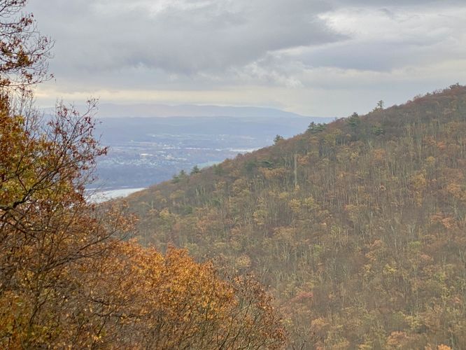
Montoursville Overlook at Tiadaghton State Forest near South Williamsport, Pennsylvania is an easy 0.1-mile out-and-back walk that leads to a mountainside vista that features views of Montoursville.

This short walk leads from a small parking turnout along the state forest road (Skyline Drive) and back to the roadside vista, known as the Montoursville Overlook. Visitors can technically drive-up to this view, but in order to not block the road, you can also turn-off the road, park and walk back to enjoy the vista on foot. The view encompasses, mostly, the eastern section of Bald Eagle Mountain, located directly across from the view; however, on the left-hand side of the view is the town of Montoursville, Pennsylvania.

Parking
Visitors will find a small parking turnout at the coordinates provided, located along Skyline Drive. The turnout is large enough to fit a couple of vehicles.

Pets
Dogs are allowed only if leashed and must be cleaned up after.
Explore 78 trails near South Williamsport, PA
  1. Parking

    41.222821, -76.940831
  2. Main Trailhead

    41.22279, -76.940733
  3. Montoursville Overlook (view toward Montoursville)

    41.2225, -76.940506
    Montoursville Overlook (view toward Montoursville)
No community routes found. To add your own hike as a Community Route for this Trail guide, leave a Trip Report with an attached GPX file.

Hazards

Ticks - Lyme Disease More Info (CDC)
Snakes

Seasons

All

Trip Reports (Reviews)

Ready to help fellow hikers? Add a trip report to share your experience and provide valuable insights for those planning their next hike. Your review makes the trail better for everyone.

Your opinion matters! Be the first to rate this trail.
0.1 miles / 0.2 km
October 28, 2023
Dogs Hiking

Weather Forecast

In South Williamsport, PA

Explore Hiking Trails

You May Also Like

New York's Best Waterfalls - Whether you're planning a day hike, roadside stop, or a leisurely short walk, this guide provides hikers, travelers, and locals alike with 63 different locations to over 100 scenic waterfalls to help plan your next adventure!
Explore

New York's Best Waterfalls

Whether you're planning a day hike, roadside stop, or a leisurely short walk, this guide provides hikers, travelers, and locals alike with 63 different locations to over 100 scenic waterfalls to help plan your next adventure!

Read

Before you boogie...

Find our trail guides useful? Consider becoming a Supporter to unlock perks!

MyHikes is an indie platform that makes exploring public trails easier for everyone. The platform has no investors, no ads, and is owned and operated by one person, Dave Miller. Dave has personally mapped and written over 1,900 trail guides on MyHikes for the public to explore. MyHikes has helped millions outdoor enthusiasts plan their next adventure.

But it takes a lot of time 🕦, money 💰, work, and espresso shots ☕ to run MyHikes, including hiking , mapping , writing , and publishing new trails with high-quality (accurate) information... along with software engineering (coding) the platform like building new features, website and mobile app development (iOS and Android), site maintainance . and much much more.

Supporters unlock website and mobile app perks with an annual one-time payment of $25 (you renew) 😎👍. Or you can simply make a Donation of your choice. Otherwise, you can support us by telling your friends about MyHikes - both quick and free 🎉

Admin avatar

Dave Miller
MyHikes Founder
🍪 We use cookies to learn about site usage, performance, and to serve map tiles. You may block cookies manually in the browser. By continuing to use MyHikes, you agree. Learn more