Miners Falls at Pictured Rocks National Lakeshore in Munising, Michigan is a moderate 1.3-mile out-and-back highly-trafficked hike that leads to two viewing platforms of the 50-foot freefall waterfall, Miners Falls.
Hike Description
This hike begins at the one and only trailhead for Miners Falls located at the coordinates provided along Miners Falls Rd and follows the Miners Falls Trail as it gradually leads hikers downhill toward Miners River gorge. There's not much to see or note along the hike in, except there are some benches so folks can take breaks. The path is gravel, wide, and doesn't have many roots to trip on and provides a nice walk through the forest.
Miners Falls Viewing Junction - Mile 0.6
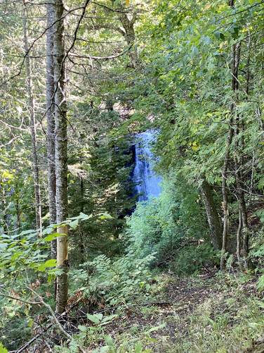
At mile 0.6, hikers will reach a split in the trail where a staircase leads ~60-feet downhill into the Miners River gorge to a beautiful viewing platform of the waterfall. To the right-hand side is a flat-grade path that leads to an obstructed (as of September, 2022) viewing platform of Miners Falls.
Miners Falls Vista - Mile 0.65
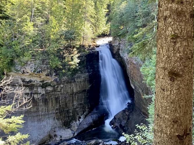
At the bottom of the stairs, located around mile 0.65, is the best viewing platform for Miners Falls. Here, hikers can enjoy the 50-foot waterfall plunging over the sandstone cliff, making for Pictured Rocks National Lakeshore's most-powerful waterfall. Also, one of the most popular waterfalls at the park as well.
Miners Falls Upper Overlook - Mile 0.7
After visiting the lower overlook, hikers might want to take a peek at the upper overlook for Miners Falls; however, it's less than stunning compared to the lower vista, as of September 2022. Some maintenance along this vista is much needed.
Hiking out is not difficult, but rather a gradual moderate walk back to parking.
Parking
Hikers will find a large parking lot at the coordinates provided, located at the end of Miners Falls Rd. The lot is large enough to fit just over a dozen vehicles. This parking lot is usually quite full by noon, even mid-week. Note that Miners Falls Road, as of September 2022, had some pretty large potholes so watch your speed and watch our for potholes in the road.
Pets
Dogs are allowed if leashed and their waste must be carried out by the hiker.
Popularity
This hike is one of the most popular day hikes at the park. You will likely be passing or hiking behind other people the entire way. While at National Parks, you also get a lot of unfriendly tourists - maybe 2/10 people would say "hello" back when passing them on the trail. The waterfall is beautiful, but the crowd is less than stunning to say the least. If you want to enjoy a secluded waterfall hike, this is not the hike for you (unless you show up early).
Warnings
Steep terrain: While hikers will not technically hike on steep terrain, they'll follow a large staircase that leads down into the Miners River gorge. For this reason, it's best to stay on-trail and stay off of the very-steep terrain within the gorge.
Hike Description
This hike begins at the one and only trailhead for Miners Falls located at the coordinates provided along Miners Falls Rd and follows the Miners Falls Trail as it gradually leads hikers downhill toward Miners River gorge. There's not much to see or note along the hike in, except there are some benches so folks can take breaks. The path is gravel, wide, and doesn't have many roots to trip on and provides a nice walk through the forest.
Miners Falls Viewing Junction - Mile 0.6
At mile 0.6, hikers will reach a split in the trail where a staircase leads ~60-feet downhill into the Miners River gorge to a beautiful viewing platform of the waterfall. To the right-hand side is a flat-grade path that leads to an obstructed (as of September, 2022) viewing platform of Miners Falls.
Miners Falls Vista - Mile 0.65
At the bottom of the stairs, located around mile 0.65, is the best viewing platform for Miners Falls. Here, hikers can enjoy the 50-foot waterfall plunging over the sandstone cliff, making for Pictured Rocks National Lakeshore's most-powerful waterfall. Also, one of the most popular waterfalls at the park as well.
Miners Falls Upper Overlook - Mile 0.7
After visiting the lower overlook, hikers might want to take a peek at the upper overlook for Miners Falls; however, it's less than stunning compared to the lower vista, as of September 2022. Some maintenance along this vista is much needed.
Hiking out is not difficult, but rather a gradual moderate walk back to parking.
Parking
Hikers will find a large parking lot at the coordinates provided, located at the end of Miners Falls Rd. The lot is large enough to fit just over a dozen vehicles. This parking lot is usually quite full by noon, even mid-week. Note that Miners Falls Road, as of September 2022, had some pretty large potholes so watch your speed and watch our for potholes in the road.
Pets
Dogs are allowed if leashed and their waste must be carried out by the hiker.
Popularity
This hike is one of the most popular day hikes at the park. You will likely be passing or hiking behind other people the entire way. While at National Parks, you also get a lot of unfriendly tourists - maybe 2/10 people would say "hello" back when passing them on the trail. The waterfall is beautiful, but the crowd is less than stunning to say the least. If you want to enjoy a secluded waterfall hike, this is not the hike for you (unless you show up early).
Warnings
Steep terrain: While hikers will not technically hike on steep terrain, they'll follow a large staircase that leads down into the Miners River gorge. For this reason, it's best to stay on-trail and stay off of the very-steep terrain within the gorge.