This hike can also be slightly punishing in sections. The first days hike along the Torry Ridge Trail is undulating and can be rocky, then the second days ascent at the end of the Mills Creek trail is a tough 1.2 mile climb with over 1,100 vertical feet of gain.
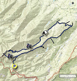
From the Slacks Overlook parking area follow the trail on the right for 60 yards to the intersection of the Slacks Trail. Turn left towards the Torry Ridge Trail as it gently climbs for 0.9 miles where the Slacks Trail ends at the Torry Ridge Trail.
Turn right on the Torry Ridge Trail and pass several small vistas between the trees then arrive at the Blue Loop Trail in 1.9 miles. This terminus of the Blue Loop Trail descends down to Lake Sherando. Continue on the Torry Ridge Trail passing the other end of the Blue Loop Trail in another 1.0 miles. From this point the Torry Ridge Trail becomes more rocky then passes over Torry Mountain and reaches the intersection of the Mills Creek Trail in 1.9 miles.
Turn left on the Mills Creek Trail as it descends towards the valley. In 0.7 miles reach the next intersection. Turn left crossing a small creek and continue on the Mills Creek Trail where it will pass a small campsite and cross a larger creek in 0.8 miles. After crossing the creek the Mills Creek Trail reaches the valley floor.
Turn left on the Mills creek (a forestry road bears right). In 1.3 miles just before crossing Mills Creek for the first time there is the best campsite on the circuit on the right. Another smaller campsite is just up the trail on the left, again just before crossing Mills Creek.
For the next 2.9 miles the Mills Creek trail crosses the creek several more times as it gradually winds its way up the valley, then steeply ascends the right side of the valley making 8 switchbacks, and gaining over 1,100 feet of elevation gain in just 1.2 miles.
The Mills Creek trail will end at a clearing and small campsite with a decent view of the valley you just climbed. From here go out to the forestry road and turn left. In 0.3 miles the road will fork. Take the left fork. Continue for another 0.1 miles and look closely for the Torry Ridge Trail on the left. The trail sign is setback 50ft to prevent vandalism.
Follow the Torry Ridge Trail, passing several good vistas, as it descends back to the intersection of the Slacks Trail in 1.2 miles. Turn right on the Slacks Trail for the remaining 0.9 miles and Slacks Overlook parking area connector trail.