-
Mile 0.0 - Walk west on FS92 towards Big Schloss for 0.5 miles to reach the Big Schloss Cut-Off Trail (don't take the old faded trail but continue for 100 more yards.
-
Mile 0.5 - Turn right and ascend the Big Schloss Cut-Off Trail. Roughly 0.5 miles from the ridgeline the trail becomes much steeper and makes several switchbacks before arriving at the Mill Mountain Trail. The Big Schloss Cut-Off Trail gains over 1,100 feet in lest than 1.5 miles.
-
Mile 1.9 - At the ridge turn left on the orange blazed Mill Mountain Trail for 0.9 miles
-
Mile 2.8 - Turn left uphill on the white blazed lookout trail to go to the Big Schloss vista.
-
Mile 3.1 - Arrive at the Big Schloss overlook. There are 270° views of Tibbet Knob, Trout Run Valley, Halfmoon Mountain, Little Sluice Mountain, and Little Schloss. The overlook can be crowded as it is also accessible from the Wolf Gap Recreation are on the Big Schloss hike. From the Big Schloss overlook return to the Big Schloss Cut-Off trail intersection with the Mill Mountain Trail.
-
Mile 4.3 - Continue north along the ridgeline and orange blazed Mill Mountain Trail. There are views through the trees of Trout Valley to the west as well as campsites along the trail.
-
Mile 6.0 - Pass Sandstone Spring with good campsites and the top of Gutter Run. Continue for 1.4 miles passing over the high point of Mill Mountain to the intersection of the Tuscarora Trail and end of the Mill Mountain Trail.
-
Mile 7.4 - Turn right downhill onto the blue blazed Tuscarora Trail for 0.6 miles and arrive at the intersection of the yellow blazed Stony Creek Trail just past a great camping spot on the right.
-
Mile 8.0 - Turn right down the yellow blazed Little Stoney Creek Trail, and in 100 yards pass the PATC Sugar Knob Cabin, then 70 yards further down the trail is a seasonal spring. The yellow blazed Little Stoney Creek Trail will continue down the valley for 2.5 miles before reaching the next campsite along the banks of the creek. Pass several more campsites in the remaining 1.3 miles to FDR92, and Little Stoney Creek parking area.
-
Mile 11.8 - Arrive back at the parking area on FDR92.
Mill Mountain Hike
Know Before You Go
- The Mill Mountain hike is an 11.8-mile circuit in Columbia Furnace, VA, suitable for a day hike or overnight backpacking trip, featuring Big Schloss, Mill Mountain, and Stony Creek.
- The hike offers varied scenic views, including a 270° vista from Big Schloss, views of Trout Run Valley from Mill Mountain Trail, and camping options along Stony Creek.
- The route involves a steep ascent up the Big Schloss Cut-Off Trail, a ridgeline walk on the Mill Mountain Trail, and a descent along the Stony Creek Trail, passing the PATC Sugar Knob Cabin.
- Distance
- 11.8 mi
- Difficulty
- Strenuous
- Type
- Loop
- Est. Time
- 5.9 hrs
- Elev. Gain
- 2,392'
- Rating
- 4.1
- Added
- February 17, 2025
- Updated
- April 05, 2025
Weather Forecast
Don't let Google decide who you trust.


538 m
729 m
727 m
Download the GPX Data for Offline Use
Supporters get exclusive access to download trail routes to the MyHikes app for offline use. Stay prepared on your adventure, even without an internet connection! Become a Supporter today to unlock this feature and hike with confidence.
Download Download Mill Mountain Hike GPX Data to the MyHikes Mobile App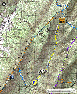
Features
- Vista / Lookout Point
- Dogs
- Mountain Summit
- Camping
- Water Source
Safety information
For your own safety: plan ahead, let someone know where you'll be, and hike at your own risk.
Hazards
Availability
Surface type
Share plans
Trip Reports (Reviews)
Ready to help fellow hikers? Add a trip report to share your experience!
34 Reviews
Helpful Links
Popular categories


You may also like

25 Best Day Hikes in Virginia
Explore the top hikes in Virginia, from iconic trails in Shenandoah National Park to hidden gems in the Blue Ridge Mountains. Find your next unforgettable outdoor adventure.

25 Best Day Hikes in West Virginia
Discover 25 of the best day hikes in West Virginia, from scenic overlooks to wilderness trails—perfect for every level of hiker.

25 Best Day Hikes in North Carolina
Discover the top 25 best day hikes in North Carolina, from breathtaking waterfalls to mountain peaks. Explore hidden gems, scenic views, and trails suitable for all skill levels, perfect for your next outdoor adventure.

Best of the Alps: Hiking, Adventure & Scenery
Plan your ultimate European Alps adventure! Discover the best hiking trails, epic scenery, and villages in the Swiss Alps, Dolomites, Chamonix, and Lake Como.
Become a Supporter

Get Directions
Ready for your hike? Select a map app below for turn-by-turn directions to the trailhead.
Stay Connected
Join our community of hikers
Follow MyHikes on Facebook Follow MyHikes on Instagram Follow MyHikes on Bluesky Follow MyHikes on Pinterest