The 47,815 acre Cranberry Wilderness in the Monongahela National
Forest has over 70 miles of hiking trails. The area is very rugged, with
densely forested areas and steep mountains. The trails in the
wilderness are not blazed, and depending on the time of year you decide
to hike, a map, compass, and GPS are highly recommended as many of the
trails can be harder to navigate. Your reward is one of the most
beautiful areas on the East Coast, with moss covered mountains, streams with pools, and exceptional solitude.
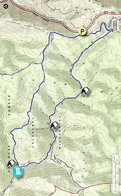
The 16.7 mile Middle Fork/Big Beechy loop hike we have mapped here is done clockwise descending the Middle Fork Trail on day 1, then ascending the Big Beechy Trail on day 2. The Big Beechy Trail is steep and rocky, and is safer to climb then descend in our opinion.
The first day hiking along Middle Fork is a pleasant stroll along countless pools. Spend the night camping next to the waterfall at the confluence of Middle Fork and Beechy Run at one of the 5 large campsites. On day 2 the first 2.4 miles is the most challenging as you climb to the ridge. You are then rewarded with old growth forest, as well as fields and stands of spruce.
- Mile 0.0 - From the Big Beechy trailhead parking area follow the path over an earthen berm, then shortly arrive at a trailhead information kiosk. In 0.2 miles the Big Beechy Trail TR207 turns right off the main wider trail. The trail junction is easily missed if you are not looking for it.
- Mile 0.2 - Stay straight as the path you have been following becomes the North Fork Trail TR272. Follow the North Fork Trail as it gently begins to descend the mountain, then in 1.2 miles arrives at the intersection of the Middle Fork Trail.
- Mile 1.4 - Stay right on the Middle Fork Trail TR271. The trail will now follow the right bank of Middle Fork. The trail is heavily forested and passes many pools along the run. Also pass several good campsites as the trail meanders its way down the valley. There are also several small tributary creeks including the North Branch, Hammond Run, Slade Branch, Slick Rock Run, and Sheets Gordon Run. The Middle Fork Trail also crosses Middle Fork to the left bank, then crosses back over to the right bank.
- Mile 7.8 - Pass the Laurelly Branch Trail TR267 on the left. This trail intersection did not have a marker as of June 2015, and also can be easy missed. Continue along the Middle Fork Trail for another 1.6 miles and arrive at the Big Beechy Trail intersection.
-
Mile 9.5 - Cross Beachy Run where the best campsite is next to the waterfall,
however if that campsite is occupied there are 4 more large campsites
in this area on the bank of Beachy Run. (The Middle Fork Trail continues
another 2.6 miles to the Three Forks Trailhead parking on FR86)
Day 2
- Mile 9.5 - Cross back over Beechy Run. Turn left on the narrow Big Beechy Trail as it steeply climbs the mountain. For the next 2.4 miles the Big Beechy Trail is rocky, narrow and has a steep drop off, watching your footing on the narrow trail is a must. There are also several sections of dense Stinging Nettle, so either were long pants, or be prepared to carefully navigate this as it intrudes on the trail in many places.
- Mille 10.9 - Once reaching the ridge the Big Beechy Trail passes over several knobs, then in another 2.3 miles arrives at the District Line Trail intersection on the left. Again this trail junction is easy to miss. Look for a small rock cairn.
- Mile 13.2 Continue on the Big Beechy Trail passing several sections where the area is covered almost entirely in moss.
- Mile 14.4 - At this point the Big Beechy Trail makes a hard right, with the overgrown and abandoned Northsouth Trail turning left. Stay right on the Big Beechy Trail as it shortly passes over the high point on Sugar Creek Mountain at 4,521ft. Now gradually descend towards the intersection of the North Fork Trail.
- Mile 15.5 - Arrive back at the intersection with the North Fork Trail. Turn left for the remaining 0.2 miles to the parking area.
- Mile 15.7 - Arrive back at the Big Beechy trailhead parking area.