Loading...

🎉 Enjoy a Free 7-Day Supporter Trial and Unlock Exclusive Perks — No Credit Card Required. Learn more.

Meneka Peak Hike

Directions
Map
Pictures
Send to App
Distance:
8.2 Miles / 13.2 km
Type:
Loop
Difficulty:
Moderate
Time to Hike:
4 hours, ~6 minutes
Features:
Surface Type:
Dirt
Park:
George Washington National Forest
Town:
Fort Valley, Virginia
Directions:
38.935381, -78.31953
Added:
February 17, 2025
Updated:
April 04, 2025
Copy Trail Link Hiking this trail? Send a friend or family member a link to this trail guide for your own safety. Hike at your own risk (disclaimer)
Loading...
Loading...
1,625'

Total Change
1,838'

Ascent
1,835'

Descent

Download the Trail Route for Offline Use

Supporters get exclusive access to download trail routes to the MyHikes app for offline use. Stay prepared on your adventure, even without an internet connection! Become a Supporter today to unlock this feature and hike with confidence.

Send to App

Meneka Peak Hike

The Meneka Peak hike in the Front Royal area of the George Washington National Forest is an abbreviated version of the Signal Knob hike. This saves about 2 miles and the 900ft second incline back up from the other other side of the ridge.

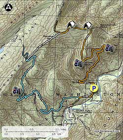
The hike starts from the right hand side of the Signal Knob parking area and is marked by both yellow (Signal Knob Trail) and Orange (Massanutten Trail) blazes. Start uphill on the yellow/orange blazed trail as it shortly passes a old stone house on your left and curves to the right around the mountain for 1.5 miles until arriving at Buzzard Rock Overlook.

The trail will take a hairpin turn back to the south then in 0.7 miles turns back to the north again following a ridge and passing a couple of great camp sites before meeting the intersection of the white blazed Meneka Peak trail that enters from the left 1.1 miles further.

Turn left on the Meneka Peak Trail as it continues uphill on the ridge crossing over the high point of your hike in 0.4 miles then gradually sloping down until reaching the intersection of the blue blazed Tuscarora Trail in 0.8 miles from the peak.

Turn left downhill on the blue blazed trail as it winds back and forth through the Bear Wallow area and passing the pink blazed Sidewinder Trail on your right in 1.7 miles.

Continue straight on the blue blazed trail as it winds downhill passing a white blazed connector trail for Elizabeth Furnace just before you cross a creek 1.0 miles from the pink blazed trail.

Continue straight on the blue blazed trail as it winds around the mountain before reaching a flatter area close to the valley and an intersection in 0.9 miles where the blue blazed trail now turns right downhill.

Again continue straight on the now orange blazed Massanutten Trail (this section was formerly the the Tuscarora Spur Trail and was reblazed in 2002) for only another 0.5 miles as it descends slightly then parallels VA678 before arriving back on the right side of the Signal Knob parking area.

Explore 92 trails near Fort Valley, VA
  1. Parking

    38.935381, -78.31953
  2. Main Trailhead

    38.935178, -78.319945
No community routes found. To add your own hike as a Community Route for this Trail guide, leave a Trip Report with an attached GPX file.

Hazards

Ticks - Lyme Disease More Info (CDC)
Snakes
Poison Ivy/Oak

Seasons

All

Blaze Color

Orange

Trip Reports

Trail Guide By:
HikingUpward user profile picture
8.2 miles / 13.2 km

Weather Forecast

In Fort Valley, VA

Explore Hiking Trails

You May Also Like

New York's Best Waterfalls - Whether you're planning a day hike, roadside stop, or a leisurely short walk, this guide provides hikers, travelers, and locals alike with 63 different locations to over 100 scenic waterfalls to help plan your next adventure!
Explore

New York's Best Waterfalls

Whether you're planning a day hike, roadside stop, or a leisurely short walk, this guide provides hikers, travelers, and locals alike with 63 different locations to over 100 scenic waterfalls to help plan your next adventure!

Read
25 Best Day Hikes in North Carolina - Discover the top 25 best day hikes in North Carolina, from breathtaking waterfalls to mountain peaks. Explore hidden gems, scenic views, and trails suitable for all skill levels, perfect for your next outdoor adventure.
Explore

25 Best Day Hikes in North Carolina

Discover the top 25 best day hikes in North Carolina, from breathtaking waterfalls to mountain peaks. Explore hidden gems, scenic views, and trails suitable for all skill levels, perfect for your next outdoor adventure.

Read

Before you boogie...

Find our trail guides useful? Consider becoming a Supporter to unlock perks!

MyHikes is an indie platform that makes exploring public trails easier for everyone. The platform has no investors, no ads, and is owned and operated by one person, Dave Miller. Dave has personally mapped and written over 1,800 trail guides on MyHikes for the public to explore. MyHikes has helped millions outdoor enthusiasts plan their next adventure.

But it takes a lot of time 🕦, money 💰, work, and espresso shots ☕ to run MyHikes, including hiking , mapping , writing , and publishing new trails with high-quality (accurate) information... along with software engineering (coding) the platform like building new features, website and mobile app development (iOS and Android), site maintainance . and much much more.

Supporters unlock website and mobile app perks with an annual one-time payment of $25 (you renew) 😎👍. Or you can simply make a Donation of your choice. Otherwise, you can support us by telling your friends about MyHikes - both quick and free 🎉

Admin user profile picture

Dave Miller
MyHikes Founder