Loading...

🌲 WINTER SALE! 50% OFF on Supporter Accounts — now through December 31st. Unlock a full year of exclusive website & app perks for better hikes. Learn More.

McKees Ridge Vista

Directions
Map
Pictures
Download McKees Ridge Vista GPX Data to the MyHikes Mobile App
Distance:
0 Miles / 0 km
Type:
Out-and-Back
Difficulty:
Easy
Time to Hike:
~5 minutes
Features:
PA Wilds
Surface Type:
Dirt
Park:
Tiadaghton State Forest
Town:
Carsontown, Pennsylvania
Get Directions:
41.38166, -77.32478
Added:
May 21, 2023
Updated:
June 09, 2023
Copy Trail Link Hiking this trail? Send a friend or family member a link to this trail guide for your own safety. Hike at your own risk (disclaimer)
Loading...

Download the GPX Data for Offline Use

Supporters get exclusive access to download trail routes to the MyHikes app for offline use. Stay prepared on your adventure, even without an internet connection! Become a Supporter today to unlock this feature and hike with confidence.

Download McKees Ridge Vista GPX Data to the MyHikes Mobile App

Key Takeaways

  • McKees Ridge Vista offers accessible, roadside views of the PA Wilds mountains near Little Pine State Park, requiring minimal to no walking.
  • Parking is limited to a small turnout along McKees Run Road, and dogs are permitted if leashed and cleaned up after.
  • The vista is not maintained in the winter, making access difficult without a snowmobile or long hike.

McKees Ridge Vista

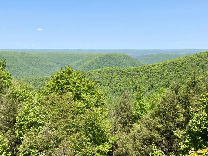
McKees Ridge Vista in Tiadaghton State Forest near Carsontown, Pennsylvania is an accessible roadside north-facing view of the mountainous plateau surrounding Little Pine State Park.

This is not a hike and just barely a walk, but rather a few steps out of your car to take in the views of the mountains. This is a great spot for folks to enjoy the mountains of the PA Wilds without having to do any hiking or really any walking if they choose not to or physically can't. If you choose to walk, the distance is negligible.

Parking
Visitors will find parking at the coordinates provided along McKees Run Road. The turnout barely exists and is simply a stop along a skinny forest road.

Pets
Dogs are allowed if leashed and cleaned up after.

No Winter Maintenance
There's no Winter maintenance on these forest roads, so don't expect to be able to reach this vista unless on a snowmobile (if permitted) or along a very long hike.
Explore 243 trails near Carsontown, PA
  1. Parking

    41.38166, -77.32478
  2. Main Trailhead

    41.381755, -77.324801
  3. View / Overlook / Vista

    41.381733, -77.324806
    View / Overlook / Vista
No community routes found. To add your own hike as a Community Route for this Trail guide, leave a Trip Report with an attached GPX file.

Hazards

Ticks - Lyme Disease More Info (CDC)
Snakes

Seasons

All

Trip Reports (Reviews)

Ready to help fellow hikers? Add a trip report to share your experience and provide valuable insights for those planning their next hike. Your review makes the trail better for everyone.

Your opinion matters! Be the first to rate this trail.
0 miles / 0 km
October 20, 2023
Pretty Nice view - fairly long drive up the narrow forest roads, but at least in good condition. Not a must see, but drove up after hiking around Little Pine State Park.
Hiking
0 miles / 0 km
May 21, 2023
Dogs Hiking

Weather Forecast

In Carsontown, PA

Explore Hiking Trails

You May Also Like

New York's Best Waterfalls - Whether you're planning a day hike, roadside stop, or a leisurely short walk, this guide provides hikers, travelers, and locals alike with 63 different locations to over 100 scenic waterfalls to help plan your next adventure!
Explore

New York's Best Waterfalls

Whether you're planning a day hike, roadside stop, or a leisurely short walk, this guide provides hikers, travelers, and locals alike with 63 different locations to over 100 scenic waterfalls to help plan your next adventure!

Read

Before you boogie...

Find our trail guides useful? Consider becoming a Supporter to unlock perks!

MyHikes is an indie platform that makes exploring public trails easier for everyone. The platform has no investors, no ads, and is owned and operated by one person, Dave Miller. Dave has personally mapped and written over 1,900 trail guides on MyHikes for the public to explore. MyHikes has helped millions outdoor enthusiasts plan their next adventure.

But it takes a lot of time 🕦, money 💰, work, and espresso shots ☕ to run MyHikes, including hiking , mapping , writing , and publishing new trails with high-quality (accurate) information... along with software engineering (coding) the platform like building new features, website and mobile app development (iOS and Android), site maintainance . and much much more.

Supporters unlock website and mobile app perks with an annual one-time payment of $25 (you renew) 😎👍. Or you can simply make a Donation of your choice. Otherwise, you can support us by telling your friends about MyHikes - both quick and free 🎉

Admin avatar

Dave Miller
MyHikes Founder
🍪 We use cookies to learn about site usage, performance, and to serve map tiles. You may block cookies manually in the browser. By continuing to use MyHikes, you agree. Learn more