McIntyre's Bluff Trail at Sterling Nature Center in Sterling, New York is a moderate 0.8-mile loop hike that features beautiful views of the jutting rock bluffs along the shore of Lake Ontario.
Hike Description
This hike begins at the end of McIntyre Road at the small parking lot and follows the main trail north as it heads downhill to reach the shores of Lake Ontario. Along the way, during the Spring, hikers may find an abundance of wildflowers like Pink Trillium, White Trillium, Yellow Violets, and purple Violets located just off-trail.
Ontario Shore / Below the Bluffs - Mile 0.3 to 0.45
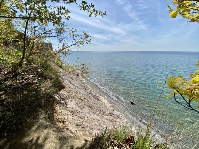
Hikers will reach the lowest point of the trail at mile 0.3, at the shore of Lake Ontario, which provides a nice view of the water, but also allows hikers to access the bluffs from below. The perspective of McIntyre's Bluff is not as interesting from the shoreline, but provides a different perspective for hikers and visitors. Watch for calving cliff sides; however. After visiting below the bluffs, hikers will want to head back to the top of the hill. Head back the way you came to the main trail, then head southwest along the loop.
Bluff Views - Mile 0.5 & 0.6
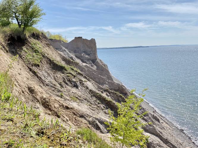
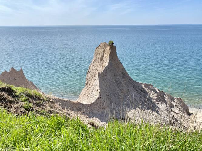
At mile 0.5, hikers will have hiked up the moderate-grade hillside to reach views of McIntyre's Bluff. Views will begin to open up at mile 0.5 and continue until mile 0.6. At mile 0.6, hikers will be standing at the McIntyre's Bluff ridge vista, which provides the best view along the trail. The turquoise waters glisten in the sunlight behind the light-colored sandstone bluffs.
After visiting the best views, hikers will follow the loop trail as it leads back to the main entrance trail. Take a right-hand turn to head back to parking for a ~0.8-mile loop hike.
Parking
Hikers will find a small parking lot at the coordinates provided. It's large enough to fit less than a dozen vehicles.
Pets
Dogs are allowed only if leashed and must be cleaned up after.
Warning
Poison ivy: Hikers should be aware of the abundance of poison ivy located just off-trail and to the sides of the trail.
Hike Description
This hike begins at the end of McIntyre Road at the small parking lot and follows the main trail north as it heads downhill to reach the shores of Lake Ontario. Along the way, during the Spring, hikers may find an abundance of wildflowers like Pink Trillium, White Trillium, Yellow Violets, and purple Violets located just off-trail.
Ontario Shore / Below the Bluffs - Mile 0.3 to 0.45
Hikers will reach the lowest point of the trail at mile 0.3, at the shore of Lake Ontario, which provides a nice view of the water, but also allows hikers to access the bluffs from below. The perspective of McIntyre's Bluff is not as interesting from the shoreline, but provides a different perspective for hikers and visitors. Watch for calving cliff sides; however. After visiting below the bluffs, hikers will want to head back to the top of the hill. Head back the way you came to the main trail, then head southwest along the loop.
Bluff Views - Mile 0.5 & 0.6
At mile 0.5, hikers will have hiked up the moderate-grade hillside to reach views of McIntyre's Bluff. Views will begin to open up at mile 0.5 and continue until mile 0.6. At mile 0.6, hikers will be standing at the McIntyre's Bluff ridge vista, which provides the best view along the trail. The turquoise waters glisten in the sunlight behind the light-colored sandstone bluffs.
After visiting the best views, hikers will follow the loop trail as it leads back to the main entrance trail. Take a right-hand turn to head back to parking for a ~0.8-mile loop hike.
Parking
Hikers will find a small parking lot at the coordinates provided. It's large enough to fit less than a dozen vehicles.
Pets
Dogs are allowed only if leashed and must be cleaned up after.
Warning
Poison ivy: Hikers should be aware of the abundance of poison ivy located just off-trail and to the sides of the trail.