Loading...

📌 Love our trails? Set MyHikes as your preferred Google source. Add Now ⛰️

Mashpee National Wildlife Refuge Hike

The Mashpee National Wildlife Refuge Hike at the Mashpee National Wildlife Refuge in Mashpee, Massachusetts is an easy 1.3-mile out-and-back hike that features a peaceful woodland setting.

Trails
This hike follows two named trails in order: Great Hay Trail, Amy Brown Trail.

Hike Description
This hike begins at the main parking lot for the wildlife refuge at the coordinates provided and follows the Great Hay Trail as it heads south. Along the way hikers will find a pine forest with sandy trail substrate and low-growing shrubs on the forest floor.

Amy Brown Trail Junction - Mile 0.5
At mile 0.5, hikers will reach a junction with the Amy Brown Trail (no signage) where this GPS track follows that trail heading west (right-hand turn). The trail ends around mile 0.65 at Amy Brown Road with another trail gate.

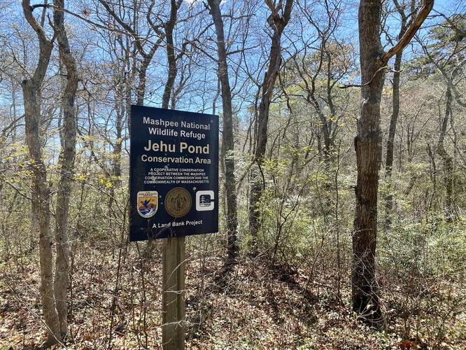
Jehu Pond Conservation Area - Mile 0.6
At mile 0.6, hikers will reach the Jehu Pond Conservation Area which is a part of the Mashpee National Wildlife Refuge, with signage marking the location.

After reaching the road, the hike heads back the opposite way to parking for a 1.3-mile out-and-back hike.

Parking
Hikers will find a small parking lot at the coordinates provided.

Pets
Dogs are allowed if leashed and must be cleaned up after.

Biking
Biking is allowed along this trail.
Explore 33 trails near Mashpee, MA

Know Before You Go

  • The Mashpee National Wildlife Refuge Hike is an easy, 1.3-mile out-and-back trail located in Mashpee, Massachusetts, offering a peaceful woodland experience.
  • The hike follows the Great Hay Trail and Amy Brown Trail, leading to the Jehu Pond Conservation Area before returning.
  • The trail is dog-friendly (leashed) and allows biking, with parking available at the trailhead.
Interactive topographic map for Mashpee National Wildlife Refuge Hike located in Mashpee, MA. Click the "View Map" button to load GPS coordinates and trail markers.
Get directions
Distance
1.3 mi
Difficulty
Easy
Type
Out-and-Back
Est. Time
39 min
Elev. Gain
33'
Rating
0.0
Added
May 09, 2023
Updated
May 16, 2023

Weather Forecast

Overnight
Low 57°F
Partly Cloudy
Tuesday
High 75°F
Sunny
Tuesday Night
Low 62°F
Mostly Clear
Wednesday
High 77°F
Mostly Sunny
Wednesday Night
Low 62°F
Partly Cloudy
Thursday
High 79°F
Chance Rain Showers
Thursday Night
Low 68°F
Chance Rain Showers
Juneteenth
High 83°F
Mostly Sunny
Friday Night
Low 66°F
Partly Cloudy
Saturday
High 82°F
Sunny
Saturday Night
Low 65°F
Mostly Clear
Sunday
High 82°F
Sunny
Sunday Night
Low 66°F
Partly Cloudy
Monday
High 79°F
Mostly Sunny then Chance Rain Showers

Don't let Google decide who you trust.

Loading...
Total Change
26 ft.
8 m
Ascent
33 ft.
10 m
Descent
35 ft.
11 m
Loading...

Download the GPX Data for Offline Use

Supporters get exclusive access to download trail routes to the MyHikes app for offline use. Stay prepared on your adventure, even without an internet connection! Become a Supporter today to unlock this feature and hike with confidence.

Download Mashpee National Wildlife Refuge Hike GPX Data to the MyHikes Mobile App

Features

Dogs
Biking

Points of interest

  1. Parking

    41.58308, -70.48982
  2. Main Trailhead

    41.582741, -70.489985
  3. Jehu Pond Conservation Area (Mashpee National Wildlife Refuge)

    41.577286, -70.493592
    Jehu Pond Conservation Area (Mashpee National Wildlife Refuge)

Safety information

For your own safety: plan ahead, let someone know where you'll be, and hike at your own risk.

Hazards

Poison Ivy or Poison Oak

Availability

All seasons

Surface type

Dirt

Trip Reports (Reviews)

Your opinion matters! Be the first to rate this trail.

Ready to help fellow hikers? Add a trip report to share your experience!

No community routes found. To add your own hike as a Community Route for this Trail guide, leave a Trip Report with an attached GPX file.

You may also like

Colorado's Million Dollar Highway - Plan a day's drive adventure along the iconic Million Dollar Highway in Colorado. Explore the best short trails, roadside stops, waterfalls, vistas, ghost towns, and hot springs within a ~6 hour road trip.
Explore

Colorado's Million Dollar Highway

Plan a day's drive adventure along the iconic Million Dollar Highway in Colorado. Explore the best short trails, roadside stops, waterfalls, vistas, ghost towns, and hot springs within a ~6 hour road trip.

Read
Glacier's Going-to-the-Sun Road - Discover the breathtaking beauty of Glacier National Park along the iconic Going-to-the-Sun Road. From stunning roadside stops to picturesque waterfalls and vistas, this engineering marvel offers endless opportunities for exploration.
Explore

Glacier's Going-to-the-Sun Road

Discover the breathtaking beauty of Glacier National Park along the iconic Going-to-the-Sun Road. From stunning roadside stops to picturesque waterfalls and vistas, this engineering marvel offers endless opportunities for exploration.

Read
🍪 We use cookies to learn about site usage and to serve map tiles. You may block cookies manually in the browser. By continuing you agree. Learn more