Loading...

❄️ WINTER SALE! 50% OFF on Supporter Accounts — now through January 31st. Unlock a full year of exclusive website & app perks. Learn More.

Maryland Heights Hike

Maryland Heights is another of those must-do circuits for most hikers in the metro area. With a spectacular view of Harpers Ferry from the main overlook, and steeped in Civil War history, this shorter circuit is a favorite for many. But be prepared for the crowds, on nicer days this hike is very busy.

The main ridge at Maryland Heights has the ruins of Union Civil War forts, trenches, gunpowder magazines, and infantry encampments. With most of the circuit having informational signage describing the different ruins.

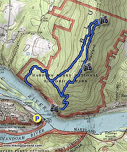
From the parking area at the train station cross the pedestrian bridge and stay left to the trailhead at the bottom of the steps. Start up the Combined Trail and pass the Naval Battery built in 1862, and first of the Union fortifications on Maryland Heights. At the next intersection, and informational sign, turn left uphill on the Stone Fort Trail as it very steeply ascends towards the ridge.

Once arriving at the ridge pass through the main fort area, then climb a set of log stairs to reach the main interior of the fort. This main section, and largest earthwork, was constructed in June of 1863. The main stone wall on the north of the fort was erected to protect it from northern attack.

From here the Stone Fort Trail will pass back to the south, with views of the Potomac River to the east through the trees. The trail will descend more steeply before ending at the intersection of the top section of the Combined Trail.

Turn left towards the overlook and in 150 yards turn right down the Overlook Trail. The main overlook for Harpers Ferry is in 0.3 miles.

Return to the Combined Trail, then follow it past the two trailheads for the Stone Fort Trail as it descends back down to Sandyhook Rd.

Explore 33 trails near Washington County, MD

Know Before You Go

  • Maryland Heights offers a rewarding 5-mile hike near Harpers Ferry, MD, with stunning views of the town from its main overlook.
  • The trail features well-preserved Civil War ruins, including forts, trenches, and informational signs that enhance the historical experience.
  • Be prepared for a steep ascent and potential crowds, especially on pleasant days, as this popular hike is known for its traffic.
Interactive topographic map for Maryland Heights Hike located in Washington County, MD. Click the "View Map" button to load GPS coordinates and trail markers.
Get directions
Distance
5.0 mi
Difficulty
Moderate
Type
Loop
Est. Time
2.5 hrs
Elev. Gain
1,675'
Rating
4.1
Added
March 22, 2025
Updated
April 06, 2025

Weather Forecast

Tonight
Low 41°F
Mostly Cloudy
Wednesday
High 48°F
Light Rain Likely
Wednesday Night
Low 22°F
Rain And Snow Likely
Thursday
High 27°F
Slight Chance Light Snow then Mostly Sunny
Thursday Night
Low 16°F
Mostly Clear
Friday
High 33°F
Mostly Sunny
Friday Night
Low 25°F
Partly Cloudy
Saturday
High 41°F
Mostly Sunny then Slight Chance Light Snow
Saturday Night
Low 21°F
Slight Chance Light Snow then Mostly Cloudy
Sunday
High 28°F
Mostly Sunny
Sunday Night
Low 16°F
Partly Cloudy
M.L. King Jr. Day
High 31°F
Mostly Sunny
Monday Night
Low 15°F
Partly Cloudy
Tuesday
High 25°F
Mostly Sunny
Loading...
Total Change
1,172'
Ascent
1,675'
Descent
1,680'
Loading...

Download the GPX Data for Offline Use

Supporters get exclusive access to download trail routes to the MyHikes app for offline use. Stay prepared on your adventure, even without an internet connection! Become a Supporter today to unlock this feature and hike with confidence.

Download Maryland Heights Hike GPX Data to the MyHikes Mobile App

Features

Vista / Lookout Point
Dogs
Mountain Summit

Points of interest

  1. Parking

    39.329168, -77.73124
  2. Main Trailhead

    39.329036, -77.731104

Safety information

For your own safety: plan ahead, let someone know where you'll be, and hike at your own risk.

Hazards

Snakes (Rattlesnakes, Copperheads, others)
Poison Ivy or Poison Oak

Availability

All seasons

Surface type

Dirt

Trip Reports (Reviews)

Rated 4.08 out of 5 based on 73 ratings.

Ready to help fellow hikers? Add a trip report to share your experience and provide valuable insights for other hikers!

0 miles / 0 km
September 18, 2025
Access to the trail will be limited starting September 22, 2025 due to a construction-related closure; apparently the main trailhead will only be reachable by a shuttle bus operated by the national park while construction is happening. There was no indication how long this will last.
Hiking
By: yishin
5.0 miles / 8.0 km
August 24, 2019
Parking is very limited - you are better off to park in town and walk through the bridge to get to the trailhead. The view at stone fort trail sucks, but it provides a good work out as the trail is steep. The grass is overgrown on the way down stone fort trail (if you hike the loop clockwise). To reach the overlook, you have to hike downward on overlook trail. This part of the trail is very crowded, but the view is so worth it. To get back, you have to hike up again the same way. The overlook trail is tough on a dog, because of the rocks scrambling.
Legacy Review
By: Rachel
5.0 miles / 8.0 km
May 27, 2019
Great hike. The trailhead parking was full, but we still got there early enough to get parking near the train station in town. It was a nice and easy walk to the trailhead. It was a bit wet, so some of the downhills from the Stone Fort were slow-going. It was a holiday weekend, but we passed many more people on our way down. Few people went out towards the stone fort so the solitude was nice.
Legacy Review
No community routes found. To add your own hike as a Community Route for this Trail guide, leave a Trip Report with an attached GPX file.

Popular categories

Scenic mountain view representing vista trails
Vista trails
Scenic gorge of cascades representing waterfall trails
Waterfall hikes
Rugged mountain terrain representing summit trails
Summit trails
Scenic mountain view representing dog-friendly trails
Dog-friendly
Scenic campsite with a view representing camping trails
Camping trails
Appalachian Trail logo representing A.T. hikes
A.T. hikes

You May Also Like

Colorado's Million Dollar Highway - Plan a day's drive adventure along the iconic Million Dollar Highway in Colorado. Explore the best short trails, roadside stops, waterfalls, vistas, ghost towns, and hot springs within a ~6 hour road trip.
Explore

Colorado's Million Dollar Highway

Plan a day's drive adventure along the iconic Million Dollar Highway in Colorado. Explore the best short trails, roadside stops, waterfalls, vistas, ghost towns, and hot springs within a ~6 hour road trip.

Read
🍪 We use cookies to learn about site usage and to serve map tiles. You may block cookies manually in the browser. By continuing you agree. Learn more