Loading...

๐Ÿ”ฅ End of Summer sale! 50% off on Supporter Accounts โ€” now through September 1st. Learn More.

Maryland Challenge Hike via Appalachian Trail

Directions
Map
Pictures
Send to App
Distance:
41.6 Miles / 66.9 km
Type:
One-Way
Difficulty:
Strenuous
Time to Hike:
20 hours, ~48 minutes
Features:
Appalachian Trail hike
Surface Type:
Dirt
Town:
Highfield-Cascade, Maryland
Directions:
39.719933, -77.507633
Added:
March 22, 2025
Updated:
April 06, 2025
Guide by:
Copy Trail Link Hiking this trail? Send a friend or family member a link to this trail guide for your own safety. Hike at your own risk (disclaimer)
Loading...
Loading...
1,632'

Total Change
6,202'

Ascent
7,171'

Descent

Download the Trail Route for Offline Use

Supporters get exclusive access to download trail routes to the MyHikes app for offline use. Stay prepared on your adventure, even without an internet connection! Become a Supporter today to unlock this feature and hike with confidence.

Send to App

Maryland Challenge Hike via Appalachian Trail

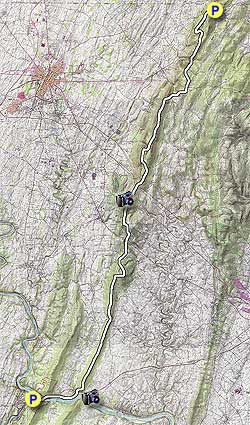
We did this hike as a one day 41 mile benefit challenge hike for the Blue Sky Fund, but we recommend doing it as a 4 day backpack, as also described on this site, which we used for planning our hike. This is also a very busy portion of the AT. If you can only do a day hike, park at the I-70 Parking area and hike 2.3 miles north on the A.T. to see Annapolis Rocks and then 1 more mile to see Black Rocks.

The directions below should give you enough information to keep your orientation and know how far you have come. We will also highlight the places to camp if doing this is done as a backpack.

DAY ONE -10 Miles

  • Mile 0.0 โ€“ Parking is at the Pen Mar County Park . If leaving a car overnight you should park in the gravel lot across from the park as the main parking lot is locked each night. The trail begins just to the right of the Overlook Pavilion and A.T. Sign, go 0.3 miles North on the AT, cross the RR Track and then reach the PA Line (Mason Dixon Line). Stop, take a photo. turn around and then head South on the AT, passing Pen Mar Park. Note: If backpacking you could leave your gear at Pen Mar Park and pick it up as you return south.
  • Mile 3.1 โ€“ Side trail to High Rock, supposedly really good views.
  • Mile 5.3 โ€“ Raven Rocks Shelter
  • Mile 6.2 โ€“ MD 491 intersection. Couple of creek crossings near here
  • Mile 8.8 โ€“ MD 77 (Foxville Rd) intersection
  • Mile 10.0 โ€“ Ensign Cowall Shelter, camp here for day 1.

DAY TWO โ€“ 8.4 Miles

  • Mile 10.3 โ€“ MD 17 (Wolfsville Rd). There is a short 0.1 mile spur trail to an AT parking lot, 10-12 cars (Parking Lot Coordinates: 39.6283,-77.5593). Cross Wolfsville Rd to continue south on the AT.
  • Mile 15.6 โ€“ Reach a couple of unmarked trails to Black Rock Cliffs in about 5.3 miles. Trail is pretty short to the cliffs.
  • Mile 16.6 โ€“ Reach spur trail for Annapolis Rocks. 0.25 miles to the Rocks.
  • Mile 18.3 โ€“ Pine Knob Shelter, this is the Day 2 campsite.

DAY THREE โ€“ 12.8 Miles

  • Mile 18.9 โ€“ I-70 AT Footbridge and spur trail to I-70/Rt 40 Parking Lot, 40 cars (Parking Lot Coordinates: 39.5355,-77.6040)
  • Mile 19.0 โ€“ Boonsboro Mountain Rd, 1st crossing.
  • Mile 19.7 โ€“ Boonsboro Mountain Rd, 2nd crossing.
  • Mile 21.9 โ€“ Pass through Washington Monument Parking lot. Note: Coming south before reaching the parking lot is a spur trail to the Monument.
  • Mile 23.7 โ€“ Turners Gap (Alt US 40, Old National Pike). Parking is directly across the road on the east side of the Inn closest to the AT (Parking Lot Coordinates:39.4841,-77.6198).If leaving car there, ask permission of the South Mountain Inn Lodge staff.
  • Mile 24.0 โ€“ Dahlgren Backpack Campground. Privy and hot shower.
  • Mile 24.8 โ€“ Reno Monument Rd.
  • Mile 25.7 โ€“ Rocky Run Shelter
  • Mile 26.2 โ€“ Lamb's Knoll Rd
  • Mile 27.9 โ€“ White Rock Cliffs
  • Mile 30.7 โ€“ Crampton Gap Shelter, this is the Day 3 campsite.

DAY FOUR โ€“ 10 Miles

  • Mile 31.1 โ€“ Crampton Gap/Gathland State Park Parking (Parking Lot Coordinates: 39.406,-77.6393). Continue on the AT by crossing Gapland Rd.
  • Mile 34.9 โ€“ Ed Garvey Shelter.
  • Mile 37.0 โ€“ Weaverton Cliffs Spur Trail.
  • Mile 38.1 โ€“ Route 340 Underpass.
  • Mile 38.4 โ€“ Railroad Crossing, turn right at C&O Canal Towpath
  • Mile 40.0 โ€“ Sandy Hook, Rt 340 Underpass
  • Mile 41.2 โ€“ Middle of Goodloe Byron footbridge into Harpers Ferry, WV.
  • Mile 41.6 โ€“ Train Station parking lot (small fee for 3 days).
    (Parking Lot Coordinates: 39.32442,-77.73)
Explore 22 trails near Highfield-Cascade, MD
  1. Parking

    39.719933, -77.507633
  2. Main Trailhead

    39.719665, -77.507
No community routes found. To add your own hike as a Community Route for this Trail guide, leave a Trip Report with an attached GPX file.

Hazards

Snakes
Poison Ivy/Oak

Seasons

All

Blaze Color

White

Trip Reports (Reviews)

Rated 4.25 out of 5 based on 16 ratings.
By: Rachel S
41.6 miles / 66.9 km
May 06, 2017
3 of my classmates and I decided to do this hike as a last-hurrah during our Senior Year of college. We had minimal hiking experience but are all fit and more or less athletic individuals. We decided to do this as an overnight, hiking from Pen Mar to Dahlgren Backpacking Campground on the first day (about 24 miles) and then from Dahlgren to Harpers Ferry the second day (about 16 miles). We began from Pen Mar in good spirits at about 8:30am and headed south (after touching PA). The weather was rainy and somewhat chilly, which made much of the uphills and rocks slippery, but not too bad. Our group woefully underestimated the toll that 24 miles would take on our bodies (and spirits), but decided to push through the whole way. Pine Knob shelter was our bail out point, if we thought we wouldn't make it all the way to Dahlgren, but we decided keep walking, knowing that we would be hiking in the dark for the last portion. I am glad we did this because we reached the Washington Monument just at sunset, and it was a GORGEOUS view. However that left us to go the remaining 1.5 miles in the dark. Finally we made it to Dahlgren around 10pm and quickly set up camp before falling right asleep. The bathrooms were a welcome sight. Waking up on Day Two was difficult but we wanted to get an early start to the day. We left Dahlgreen around 8am and continued south. The uphill to Gathland State Park was brutal, but we made it with frequent stops. It was more or less flat after that, but our feet hurt with every step and the downhills were difficult on our knees. We were so focused on finishing the trip that we didn't stop to enjoy the views off trail- something I wish we took the time for, in retrospect. It felt like forever until we made it to the final switchbacks and then the C&O; Towpath, but the level ground was welcome. By the time we reached Harpers Ferry I thought my feet would fall off. All in all, the hike was HARD (especially for some inexperienced, but very eager friends) but so worth it in the end. The best part of the trip was some Trail Magic we experienced on Day 2. A family in the parking lot of Gathland had a picnic table set up with lots of food and snacks for the taking. It was the highlight of the trip. I would recommend, perhaps as a 3 or 4 day trip so to more enjoy the journey.
Legacy Review
By: grc
41.6 miles / 66.9 km
October 24, 2015
My friend and I broke this up into two separate trips. On the first trip we hiked from the 70 parking lot to Harpers Ferry and the second trip was Pen-Mar to the 70 parking lot. This was a fantastic hike, a bit warmer a month ago when we did the "second half" from this past weekend when we did the "first half". Our trip: Day 1, Pen-Mar to Ensign, solid foliage in late October, climb to High Rock is a true scramble and a solid climb. Definitely recommend going to High Point for the views and photos. Moved along to the Ravens Rock shelter for lunch beautiful shelter. Got to Ensign at about 4PM, fairly crowded for late in the year, but everything went smoothly. If using a water filter like a Sawyer for the still spring, make sure to bring something to scoop/pour water to the bags (I used my JetBoil w/ lid and worked like a charm). Day 2, Ensign to 70, pretty good climb up the ridge to begin the morning would rather tackle this early in the day. Stopped at Black Rock Overlook later in the hike... great views. Day 3, 70 to Treehouse Camp, we had great weather on this one in mid-September, stop at the overlook at the Washington Monument and there is one memorable climb. We decided to pass the shelter near Gathland and get a site at Treehouse Camp which gave us a little more room to spread out. Despite the ability to buy a steak there, we stuck to our Mountain House. This was my favorite day of the hike. Day 4, Treehouse Camp to HFWV, very reminiscent of Day 2. An initial climb up the mountain and then walking along the ridge until coming to a pretty solid descent to the Potomac River. Neither of us are in the greatest of shape or experienced on multi-day hikes, but we hobbled into town after 2 days/~24 miles of the 'second half'. I would prefer to tackle new sections of the AT, but living in Montgomery County, MD, this is a very manageable drive for great overnight hiking. Highly recommend this as a beginner backpacking trip to those in decent shape, either the 4day/3night approach on this site or broken up into two hike variety like we did. Challenging, but manageable.
Legacy Review
By: Soggy
41.6 miles / 66.9 km
August 03, 2015
I section hiked this in 3 days from Harpers Ferry to Rocky Run Shelter then to the former Free State Hostel then to Waynesboro. I would recommend carrying plenty of water in the section from Harpers Ferry to Rocky Run. It is a lot of uphill and not a lot of spots to get water. Gathland has water but the drop over to Greenbriar may or may not be marked. Don't rely on this spot to get water. Also, there are bears near the Rocky Run Shelter. They didn't come in to the shelter but to be safe hang your bags. Another tip make sure you watch the trail sign at the Pogo campsite. You can easily drop down to another trail. It is a spur trail and is Rocky and all down hill. If you keep going you will have to road walk many miles to smithsburg to get back on the AT or walk a half mile or so back up to the top. I have met people who have done this. Where the water comes out of the spring at Pogo do not turn left going north continue on the AT. I forgot to mention I stayed at the Tea Horse Hostel in Harpers Ferry very reasonable and is about a quarter to half mile or so past the ATC on the same road in Bolivar, WV. Basically the high ground of Harpers ferry. Let's see...hit Waynesboro when you are done. Great burgers down hill from the Mason Dixon line at Blondies Tavern. Great sushi at Sapporo on the square in Waynesboro. Great wings and beer at the Dawg House on the West End of Waynesboro. If you stay in the motel in Waynesboro you can take a walk west about 200 yards west and look right there is a laundromat behind the Turkey Hill mini mart. Oh and make sure you walk 200 yards off the trail to see High Rock overlook it is the best view on this part of the AT. I think it's better than the Bears Den Overlook.
Legacy Review

Weather Forecast

In Highfield-Cascade, MD

Explore Hiking Trails

You May Also Like

Colorado's Million Dollar Highway - Plan a day's drive adventure along the iconic Million Dollar Highway in Colorado. Explore the best short trails, roadside stops, waterfalls, vistas, ghost towns, and hot springs within a ~6 hour road trip.
Explore

Colorado's Million Dollar Highway

Plan a day's drive adventure along the iconic Million Dollar Highway in Colorado. Explore the best short trails, roadside stops, waterfalls, vistas, ghost towns, and hot springs within a ~6 hour road trip.

Read
New York's Best Waterfalls - Whether you're planning a day hike, roadside stop, or a leisurely short walk, this guide provides hikers, travelers, and locals alike with 63 different locations to over 100 scenic waterfalls to help plan your next adventure!
Explore

New York's Best Waterfalls

Whether you're planning a day hike, roadside stop, or a leisurely short walk, this guide provides hikers, travelers, and locals alike with 63 different locations to over 100 scenic waterfalls to help plan your next adventure!

Read

Before you boogie...

Find our trail guides useful? Consider becoming a Supporter to unlock perks!

MyHikes is an indie platform that makes exploring public trails easier for everyone. The platform has no investors, no ads, and is owned and operated by one person, Dave Miller. Dave has personally mapped and written over 1,800 trail guides on MyHikes for the public to explore. MyHikes has helped millions outdoor enthusiasts plan their next adventure.

But it takes a lot of time ๐Ÿ•ฆ, money ๐Ÿ’ฐ, work, and espresso shots โ˜• to run MyHikes, including hiking , mapping , writing , and publishing new trails with high-quality (accurate) information... along with software engineering (coding) the platform like building new features, website and mobile app development (iOS and Android), site maintainance . and much much more.

Supporters unlock website and mobile app perks with an annual one-time payment of $25 (you renew) ๐Ÿ˜Ž๐Ÿ‘. Or you can simply make a Donation of your choice. Otherwise, you can support us by telling your friends about MyHikes - both quick and free ๐ŸŽ‰

Admin user profile picture

Dave Miller
MyHikes Founder