The Martis Peak Fire Outlook Trail is a difficult 8-mile out-and-back trail that follows the Martis Peak FS Road all the way to the top where you get amazing views of Lake Tahoe.
This hike was 8 miles roundtrip, with about 1700-ft of elevation gain. In the winter, Martis Peak Road is covered in snow and you would never notice that it is paved. The forest was peaceful and quiet.
Mile 0 to 1.3: Hike and follow the road for 1.3-miles until you reach a fork in the road. Take a left-hand turn to continue hiking uphill towards Martis Peak.
Mile 1.3 to 2.6: Around mile 2.6 you'll come across yet another fork in the road -- stay right to continue hiking up towards Martis Peak.
Mile 2.6 to 3.3: At mile 3.3, the road curves with another fork in the road that leads to a parking area during warmer months. Continue hiking uphill and stay left along the curve to reach Martis Peak.
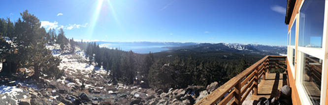
Mile 3.3 to 4: At mile 4 you'll finally reach the Martis Peak Fire Outlook with amazing views of Lake Tahoe below.
Lookout: Martis Peak Fire lookout is a small hut with sweeping views in every direction except to the east, which is blocked by Martis Peak itself. From the lookout, you can see Lake Tahoe below - from Desolation to Donner Pass.
Parking: Parking can be found at the entrance to Martis Peak Road at the parking coordinates provided.
Pets: Dogs are allowed on leash and their waste must be carried out.
For more details, check out the Martis Peak Norcalhiker blog post.
This hike was 8 miles roundtrip, with about 1700-ft of elevation gain. In the winter, Martis Peak Road is covered in snow and you would never notice that it is paved. The forest was peaceful and quiet.
Mile 0 to 1.3: Hike and follow the road for 1.3-miles until you reach a fork in the road. Take a left-hand turn to continue hiking uphill towards Martis Peak.
Mile 1.3 to 2.6: Around mile 2.6 you'll come across yet another fork in the road -- stay right to continue hiking up towards Martis Peak.
Mile 2.6 to 3.3: At mile 3.3, the road curves with another fork in the road that leads to a parking area during warmer months. Continue hiking uphill and stay left along the curve to reach Martis Peak.
Mile 3.3 to 4: At mile 4 you'll finally reach the Martis Peak Fire Outlook with amazing views of Lake Tahoe below.
Lookout: Martis Peak Fire lookout is a small hut with sweeping views in every direction except to the east, which is blocked by Martis Peak itself. From the lookout, you can see Lake Tahoe below - from Desolation to Donner Pass.
Parking: Parking can be found at the entrance to Martis Peak Road at the parking coordinates provided.
Pets: Dogs are allowed on leash and their waste must be carried out.
For more details, check out the Martis Peak Norcalhiker blog post.