Loading...

Distance:
0 Miles / 0 km
Type:
Out-and-Back
Difficulty:
Easy
Time to Hike:
~5 minutes
Features:
PA Wilds
Surface Type:
Universal Access
Town:
Wyalusing, Pennsylvania
Directions:
41.730764, -76.297277
Added:
May 28, 2023
Updated:
June 09, 2023
Loading...
Loading...
5 '

Total Change
5 '

Ascent
5 '

Descent

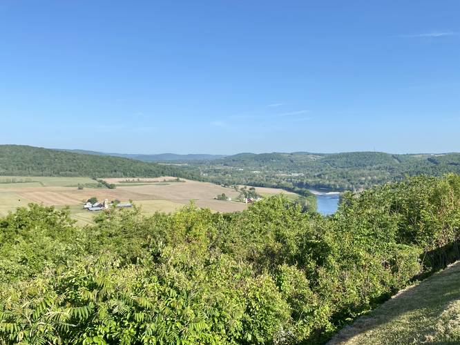
The Marie Antoinette Overlook in Wyalusing, Pennsylvania is an accessible view of the Susquehanna River, the valley below, and the surrounding mountains.

This is not a hike, but rather a few steps out of your car to take in the views of the Susquehanna River, the mountains surrounding it, and the valley below. This is a great spot for folks to enjoy the mountains of the PA Wilds without having to do much walking. If you choose to walk, the distance is negligible, but there are different vantage points from each end of the parking turnout. During Spring, this is a great spot to find wildflowers like wild phlox.

Parking
Visitors will find a very large parking at the coordinates provided.

Pets
Dogs are allowed if leashed and must be cleaned up after.

Explore 30 trails near Wyalusing, PA
  1. Parking

    41.730764, -76.297277
  2. Main Trailhead

    41.730818, -76.297373
  3. View of the Susquehanna River from the Marie Antoinette Overlook

    41.730914, -76.297439
    View of the Susquehanna River from the Marie Antoinette Overlook
No community routes found. To add your own hike as a Community Route for this Trail guide, leave a Trip Report with an attached GPX file.

Hazards

Ticks - Lyme Disease More Info (CDC)

Seasons

All

Photo Albums

2 Trip Reports

No Star-Ratings
Write-up by:
Admin user profile picture
0 miles / 0 km
Trail added
May 28, 2023
Hiked on
May 28, 2023
Updated on
June 09, 2023
0 miles / 0 km
May 28, 2023
Dogs Hiking

Weather Forecast

In Wyalusing, PA

Explore Hiking Trails

New Hikes

Peters Mountain via Appalachian Trail
3.9 Miles
6.3 km
Moderate
Loop
Congaree Boardwalk Loop
2.5 Miles
4 km
Easy
Loop
Battery Warren Trail
1 Mile
1.6 km
Easy
Out-and-Back
Diana's Baths Trail
1.2 Miles
1.9 km
Easy
Out-and-Back

Before you leave...

MyHikes is an indie web platform aimed to make exploring public trails easier for everyone. The site has no investors and is owned and operated by one person, Dave Miller (Founder & Admin). As the Founder, main contributor, and doer-of-all-things for MyHikes, I share my trips with over-detailed write-ups for fun on a volunteer basis and I believe that public trail information should be available to everyone.

It takes a lot of time 🕦, money 💰, and effort (including espresso shots ☕) to run MyHikes, including hiking , mapping , writing , and publishing new trails with high-quality content... along with building new features, moderating, site maintainance, and app development for iOS and Android . I simply ask that if you find MyHikes' trail guides helpful to please consider becoming a Supporter to help keep the site, iOS, and Android apps available to everyone.

Supporters unlock website and in-app perks with a one-time payment of $25 (you renew) 😎👍. Or you can simply make a Donation of your choice without a MyHikes user account. Otherwise, telling your friends about MyHikes is the next-best thing - both quick and free 🎉

Thanks for visiting MyHikes and have a great hike!️

Admin user profile picture

Dave Miller
MyHikes Founder & Admin