The Marconi Station Site Trail at Cape Cod National Seashore in Wellfleet, Massachusetts is an easy 0.3-mile loop trail that features the historical Marconi wireless station sit and views of the Atlantic Ocean and surrounding dunes.
Walk Description
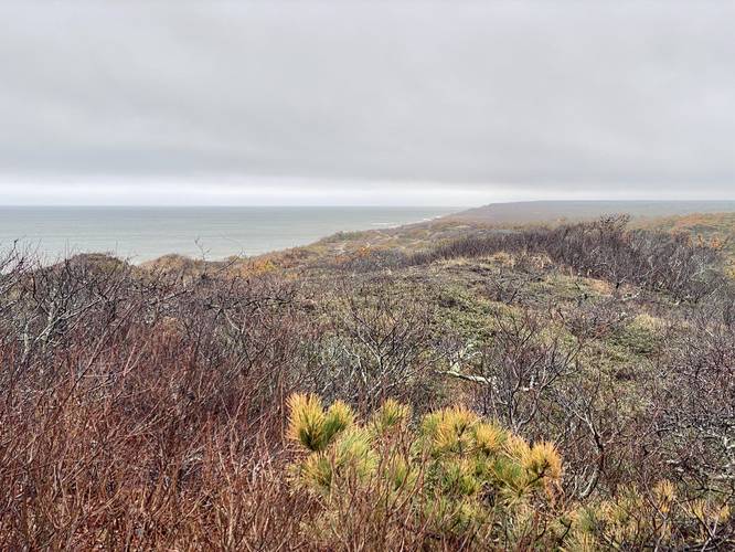
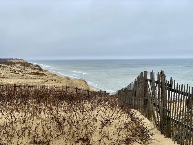
This is less of a hike and more of a scenic walk that begins at the large parking lot at the coordinates provided and follows the Marconi Station Site Trail starting at the southern terminus. The universally-accessible trail winds its way up to a viewing platform that provides historical information signs and views of the ocean and dunes.
Marconi Station Site - Mile 0.14
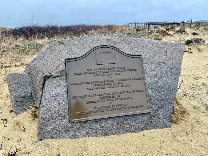
At mile 0.14, walkers will reach the historical Marconi Station Site area which is marked with a commemorative stone and plaque.
After visiting the station site, the trail will loop around to the north before heading back to parking. If you're looking for a nice day hike, be sure to check out the unique and "enchanted" Atlantic White Cedar Swamp Trail located in the same parking lot.
History
From this site on January 18, 1903 Italian-born Guglielmo Marconi (an inventor) sent the world's very first transatlantic wireless communication between the U.S. and Europe, to Cornwall, England. While wireless communication, today, is commonplace, back in the early 1900s it was something out of science fiction and thus Marconi revolutionized communication forever. The station was decommissioned in 1917 and a new one was built in Chatham, MA. Here at the Wellfleet site, the former equipment fell into the ocean due to erosion, but some remnants still remain. This is total speculation, but in the north end of the trail's loop are some old bricks and large chunks of wooden planks - which could very well be pieces of the old station, but this is simply a guess. Note: the plaque reads "January 19, 1903" while the historical information sign reads "January 18, 1903" as the first wireless communication date. According to wikipedia, the 18th is the "proper" date; however, as a non-historian, I'm not sure which date it really was. Maybe the plaque is wrong.
Universal Access
This trail follows a paved and universally-accessible path for almost the entire length of the trail. Note that near the actual station site (north in the trail data), the sand sometimes overtakes the paved trail, so you might not be able to follow the entire pathway as a fully accessible trail.
Parking
Walkers will find a large parking lot at the coordinates provided. The lot is large enough to fit a couple dozen vehicles.
Pets
Dogs are allowed on this trail but must be leashed and cleaned up after.
Walk Description
This is less of a hike and more of a scenic walk that begins at the large parking lot at the coordinates provided and follows the Marconi Station Site Trail starting at the southern terminus. The universally-accessible trail winds its way up to a viewing platform that provides historical information signs and views of the ocean and dunes.
Marconi Station Site - Mile 0.14
At mile 0.14, walkers will reach the historical Marconi Station Site area which is marked with a commemorative stone and plaque.
After visiting the station site, the trail will loop around to the north before heading back to parking. If you're looking for a nice day hike, be sure to check out the unique and "enchanted" Atlantic White Cedar Swamp Trail located in the same parking lot.
History
From this site on January 18, 1903 Italian-born Guglielmo Marconi (an inventor) sent the world's very first transatlantic wireless communication between the U.S. and Europe, to Cornwall, England. While wireless communication, today, is commonplace, back in the early 1900s it was something out of science fiction and thus Marconi revolutionized communication forever. The station was decommissioned in 1917 and a new one was built in Chatham, MA. Here at the Wellfleet site, the former equipment fell into the ocean due to erosion, but some remnants still remain. This is total speculation, but in the north end of the trail's loop are some old bricks and large chunks of wooden planks - which could very well be pieces of the old station, but this is simply a guess. Note: the plaque reads "January 19, 1903" while the historical information sign reads "January 18, 1903" as the first wireless communication date. According to wikipedia, the 18th is the "proper" date; however, as a non-historian, I'm not sure which date it really was. Maybe the plaque is wrong.
Universal Access
This trail follows a paved and universally-accessible path for almost the entire length of the trail. Note that near the actual station site (north in the trail data), the sand sometimes overtakes the paved trail, so you might not be able to follow the entire pathway as a fully accessible trail.
Parking
Walkers will find a large parking lot at the coordinates provided. The lot is large enough to fit a couple dozen vehicles.
Pets
Dogs are allowed on this trail but must be leashed and cleaned up after.