The Atlantic White Cedar Swamp Trail at Cape Cod National Seashore in Wellfleet, Massachuetts is a moderate 1.1-mile loop hike that features scenic swamp that feels like an ecosystem out of the Pacific Northwest.
Hike Description
This hike begins at the main trailhead located at the southern end of the parking lot, near the coordinates provided and follows the Atlantic White Cedar Swamp Trail as it heads due-west. Within the first 100-feet is a fork in the trail - for new folks here, hiking the left-hand side (southern portion of the loop) first is a more scenic experience than taking the old service road (right-hand / northern side).
The trail doesn't have much to see along the way to the swamp outside of the sandy substrate and low-growing pines that provide tree cover. The trail undulates a bit along the way with some downhill sections.
Straight to Swamp - Mile 0.44
Around mile 0.44, hikers will reach a trail junction - go straight here to head into the swamp.
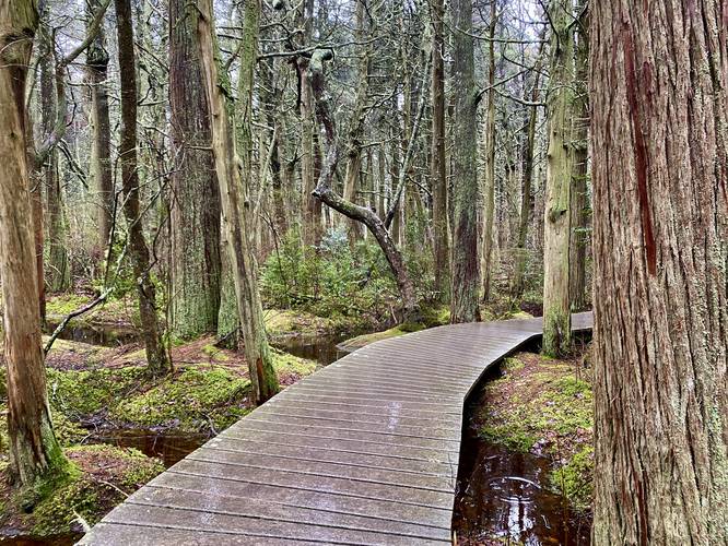
Swamp Boardwalk - Mile 0.45 to 0.75
Starting at mile 0.45, hikers will officially enter the Atlantic White Cedar Swamp where the trail will begin to follow a boardwalk path. Here, hikers begin to get the best "views" and scenery of the swamp's dark red-tainted waters, vibrant green moss, and lichen-covered trees. Around mile 0.5, the trail will split where you can hike a short boardwalk bisecting trail to the right-hand side, or follow this GPS recording for a longer, more scenic hike. Near this fork, however, are benches for people to sit and relax where-as the left-hand turn has no benches. From mile 0.5 to 0.7, hikers will walk through a magic, almost "enchanted" forest, of Atlantic White Cedar trees. Their tannis leak into the surrounding swamp waters, causing the red tint. When minimal sunlight reaches these waters, they can almost appear to be totally black, with red-ish boundaries near the water's edge. Take a stroll here and go slow to take in the scenery - this area reminded me of the Pacific Northwest temperate rainforests with lichen growing on the trees and vibrant green mosses littering the forest floor. Around mile 0.7 the trail will reach the bisecting boardwalk once more.
Straight and Slight-Right - Mile 0.75
Around mile 0.75, the boardwalk and swamp will be over and hikers will reach a trail junction once more. Here, hike straight and slightly to the right to follow trail kiosk signs back to parking. Simply, do not take a left-hand turn and do not take a sharp right-hand turn at this junction. Hikers will follow the old wireless road out to parking, which heads back uphill and does not have anything to see along the way.
Kettle Hole / Kettle Pond
Note that this swamp is a kettle hole or kettle pond which are formed by glacier deposits that usually calved off of glaciers and stuck into the ground, creating large depressions in the ground, and slowly melted over time - leaving behind a lowland depressions which fill with water. According to the signage at the Marconi Station Site Trail, located in the same parking lot, this swamp's kettle hole was formed approximately 18,000 years ago when the last glaciers retreated from this area. It's believed that water intersected this kettle hole about 7,000 years ago.
Parking
Hikers will find a large parking lot at the coordinates provided. The lot is large enough to fit a few dozen vehicles.
Pets
Dogs are not allowed on this trail.
Hike Description
This hike begins at the main trailhead located at the southern end of the parking lot, near the coordinates provided and follows the Atlantic White Cedar Swamp Trail as it heads due-west. Within the first 100-feet is a fork in the trail - for new folks here, hiking the left-hand side (southern portion of the loop) first is a more scenic experience than taking the old service road (right-hand / northern side).
The trail doesn't have much to see along the way to the swamp outside of the sandy substrate and low-growing pines that provide tree cover. The trail undulates a bit along the way with some downhill sections.
Straight to Swamp - Mile 0.44
Around mile 0.44, hikers will reach a trail junction - go straight here to head into the swamp.
Swamp Boardwalk - Mile 0.45 to 0.75
Starting at mile 0.45, hikers will officially enter the Atlantic White Cedar Swamp where the trail will begin to follow a boardwalk path. Here, hikers begin to get the best "views" and scenery of the swamp's dark red-tainted waters, vibrant green moss, and lichen-covered trees. Around mile 0.5, the trail will split where you can hike a short boardwalk bisecting trail to the right-hand side, or follow this GPS recording for a longer, more scenic hike. Near this fork, however, are benches for people to sit and relax where-as the left-hand turn has no benches. From mile 0.5 to 0.7, hikers will walk through a magic, almost "enchanted" forest, of Atlantic White Cedar trees. Their tannis leak into the surrounding swamp waters, causing the red tint. When minimal sunlight reaches these waters, they can almost appear to be totally black, with red-ish boundaries near the water's edge. Take a stroll here and go slow to take in the scenery - this area reminded me of the Pacific Northwest temperate rainforests with lichen growing on the trees and vibrant green mosses littering the forest floor. Around mile 0.7 the trail will reach the bisecting boardwalk once more.
Straight and Slight-Right - Mile 0.75
Around mile 0.75, the boardwalk and swamp will be over and hikers will reach a trail junction once more. Here, hike straight and slightly to the right to follow trail kiosk signs back to parking. Simply, do not take a left-hand turn and do not take a sharp right-hand turn at this junction. Hikers will follow the old wireless road out to parking, which heads back uphill and does not have anything to see along the way.
Kettle Hole / Kettle Pond
Note that this swamp is a kettle hole or kettle pond which are formed by glacier deposits that usually calved off of glaciers and stuck into the ground, creating large depressions in the ground, and slowly melted over time - leaving behind a lowland depressions which fill with water. According to the signage at the Marconi Station Site Trail, located in the same parking lot, this swamp's kettle hole was formed approximately 18,000 years ago when the last glaciers retreated from this area. It's believed that water intersected this kettle hole about 7,000 years ago.
Parking
Hikers will find a large parking lot at the coordinates provided. The lot is large enough to fit a few dozen vehicles.
Pets
Dogs are not allowed on this trail.