Loading...

๐ŸŽ‰ Enjoy a Free 7-Day Supporter Trial and Unlock Exclusive Perks โ€” No Credit Card Required. Learn more.

Manistique East Breakwater Lighthouse

Directions
Map
Pictures
Send to App
Distance:
0.5 Miles / 0.8 km
Type:
Out-and-Back
Difficulty:
Easy
Time to Hike:
~15 minutes
Features:
Surface Type:
Universal Access
Park:
Lakeview Park
Town:
Manistique, Michigan
Directions:
45.95039, -86.2457
Added:
September 25, 2022
Updated:
October 06, 2022
Copy Trail Link Hiking this trail? Send a friend or family member a link to this trail guide for your own safety. Hike at your own risk (disclaimer)
Loading...
Loading...
21'

Total Change
21'

Ascent
21'

Descent

Download the Trail Route for Offline Use

Supporters get exclusive access to download trail routes to the MyHikes app for offline use. Stay prepared on your adventure, even without an internet connection! Become a Supporter today to unlock this feature and hike with confidence.

Send to App

Manistique East Breakwater Lighthouse

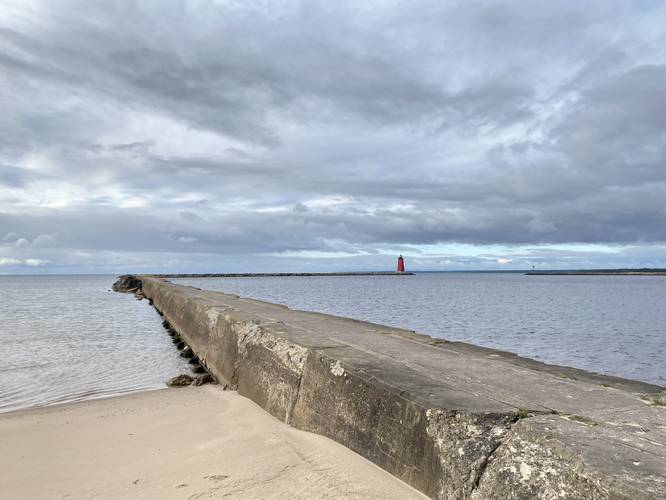
The Manistique East Breakwater Lighthouse walk at Lakeview Park in Manistique, Michigan
is an easy 0.5-mile out-and-back walk that leads along a universally accessible boardwalk that provides views of the lighthouse.

Universal Accessibility
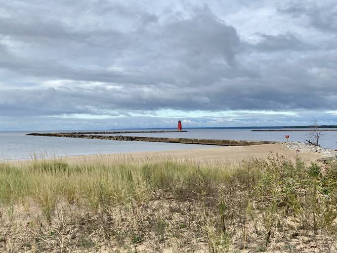
Note that this walk begins along a paved trail that eventually turns into a boardwalk - both are universally accessible; however, this track leaves the accessible trail and leads into the sand where it ends at the breakwater - that portion is not universally accessible (i.e. reaching the breakwater and the base of the lighthouse is not universally accessible).

This is not a hike but rather a short walk along the Manistique Boardwalk to get views of the Manistique East Breakwater Lighthouse. Walkers will get views of the lighthouse from the Manistique Boardwalk or from the beach, but the views are arguably nicer from the boardwalk than from up-close on the breakwater. Note that this boardwalk trail continues much further than the provided track.

Fishing
The breakwater is a popular fishing location for locals as the breakwater provides a pier and access to the base of the lighthouse.

Parking
Walkers will find parking at the coordinates provided. The lot is large enough to fit a couple dozen vehicles.

Pets
Dogs are allowed if leashed and their waste must be carried out by the hiker.

Warning
Breakwater waves: During storms, the breakwater is not safe to walk on (for fishing or other purposes). Do not get washed away by the waves and stay off of the breakwater during inclement weather.
Explore 1 trail near Manistique, MI
  1. Parking

    45.95039, -86.2457
  2. Main Trailhead

    45.95039, -86.2457
  3. Manistique Lighthouse from beginning of breakwater

    45.948089, -86.244308
    Manistique Lighthouse from beginning of breakwater
  4. Manistique Lighthouse from the boardwalk

    45.948581, -86.243447
    Manistique Lighthouse from the boardwalk
No community routes found. To add your own hike as a Community Route for this Trail guide, leave a Trip Report with an attached GPX file.

Hazards

Ticks - Lyme Disease More Info (CDC)

Seasons

All

Trip Reports

Trail Guide By:
Admin user profile picture
0.5 miles / 0.8 km
0.5 miles / 0.8 km
September 22, 2022
Hiking

Weather Forecast

In Manistique, MI

Explore Hiking Trails

You May Also Like

Colorado's Million Dollar Highway - Plan a day's drive adventure along the iconic Million Dollar Highway in Colorado. Explore the best short trails, roadside stops, waterfalls, vistas, ghost towns, and hot springs within a ~6 hour road trip.
Explore

Colorado's Million Dollar Highway

Plan a day's drive adventure along the iconic Million Dollar Highway in Colorado. Explore the best short trails, roadside stops, waterfalls, vistas, ghost towns, and hot springs within a ~6 hour road trip.

Read
Glacier's Going-to-the-Sun Road - Discover the breathtaking beauty of Glacier National Park along the iconic Going-to-the-Sun Road. From stunning roadside stops to picturesque waterfalls and vistas, this engineering marvel offers endless opportunities for exploration.
Explore

Glacier's Going-to-the-Sun Road

Discover the breathtaking beauty of Glacier National Park along the iconic Going-to-the-Sun Road. From stunning roadside stops to picturesque waterfalls and vistas, this engineering marvel offers endless opportunities for exploration.

Read
New York's Best Waterfalls - Whether you're planning a day hike, roadside stop, or a leisurely short walk, this guide provides hikers, travelers, and locals alike with 63 different locations to over 100 scenic waterfalls to help plan your next adventure!
Explore

New York's Best Waterfalls

Whether you're planning a day hike, roadside stop, or a leisurely short walk, this guide provides hikers, travelers, and locals alike with 63 different locations to over 100 scenic waterfalls to help plan your next adventure!

Read

Before you boogie...

Find our trail guides useful? Consider becoming a Supporter to unlock perks!

MyHikes is an indie platform that makes exploring public trails easier for everyone. The platform has no investors, no ads, and is owned and operated by one person, Dave Miller. Dave has personally mapped and written over 1,800 trail guides on MyHikes for the public to explore. MyHikes has helped millions outdoor enthusiasts plan their next adventure.

But it takes a lot of time ๐Ÿ•ฆ, money ๐Ÿ’ฐ, work, and espresso shots โ˜• to run MyHikes, including hiking , mapping , writing , and publishing new trails with high-quality (accurate) information... along with software engineering (coding) the platform like building new features, website and mobile app development (iOS and Android), site maintainance . and much much more.

Supporters unlock website and mobile app perks with an annual one-time payment of $25 (you renew) ๐Ÿ˜Ž๐Ÿ‘. Or you can simply make a Donation of your choice. Otherwise, you can support us by telling your friends about MyHikes - both quick and free ๐ŸŽ‰

Admin user profile picture

Dave Miller
MyHikes Founder