Loading...

🔥 End of Summer sale! 50% off on Supporter Accounts — now through September 1st. Learn More.

Manassas National Battlefield Bull Run

Directions
Map
Pictures
Send to App
Distance:
5.1 Miles / 8.2 km
Type:
Loop
Difficulty:
Moderate
Time to Hike:
2 hours, ~33 minutes
Features:
Surface Type:
Dirt
Town:
Manassas, Virginia
Directions:
38.812657, -77.521347
Added:
April 03, 2025
Updated:
April 06, 2025
Guide by:
Copy Trail Link Hiking this trail? Send a friend or family member a link to this trail guide for your own safety. Hike at your own risk (disclaimer)
Loading...
Loading...
114'

Total Change
332'

Ascent
332'

Descent

Download the Trail Route for Offline Use

Supporters get exclusive access to download trail routes to the MyHikes app for offline use. Stay prepared on your adventure, even without an internet connection! Become a Supporter today to unlock this feature and hike with confidence.

Send to App

Manassas National Battlefield Bull Run

The Manassas Battlefield Park is steeped in history. The site of two major civil war battles the park has two main loops that pass many historic points of interest, including the spot where confederate General Thomas Jackson got his nickname 'Stonewall Jackson'. Within the rolling plains of Virginia the hikes here are appropriate for all ages.

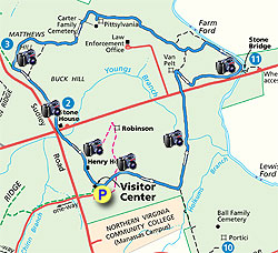
From the visitors center parking area walk over to the statue of General Thomas J. Jackson. This is where Brigadier General Barnard E. Bee, trying to rally his troops, pointed to General Thomas J. Jackson's line where the cannons now stand, and shouted 'There stands Jackson like a stone wall! Rally behind the Virginians!' From this point walk past to the cannons and line of trees where the main section of the blue blazed First Manassas Trail loop starts.

The Manassas Battlefield Park has many side trails, so remember, when you get to an intersection just follow the blue blazed (blue disks on posts) trail. Once entering the tree stand you will pass a clearing on the left in 0.2 miles, cross a wooden footbridge, and arrive at the first intersection in 0.5 miles.

Turn left following the blue marked trail and cross a small stream in 0.3 miles. Walk through the first of several fields before you cross US29 in another 0.3 miles. Shortly after crossing US29 the yellow blazed trail turns left, remain straight for another 0.1 miles to the top on the rise and the site of the Van Pelt House.

The blue blazed trail will now makes a hairpin turn to the right towards the Stone Bridge. After descending slightly, veering back to the left, then turning to the right again the trail passes through a low lying area and crosses a 0.2 mile wooded foot walk before arriving at the Stone Bridge and Bull Run.

Do not cross the Stone Bridge, but turn left along Bull Run for 0.3 miles before the trail turns left uphill and exiting into another field. Continue to follow the trail as it passes through the field then enters a tree stand again and passing the Carter family cemetery in 0.2 miles. From the cemetery junction continue on the blue trail as it exits into another field in another 0.5 miles. Continue straight to the top of Mathews Hill and line of cannons.

Turn left downhill past the canons through two fields before descending to the intersection of US29, Sudley Road and location of the Stone House which served as a field hospital in both battles fought here.

Cross US29 at the intersection following the trail over a wooden footbridge and uphill past the Henry House before arriving back at the National Park Service visitors center.

Explore 27 trails near Manassas, VA
  1. Parking

    38.812657, -77.521347
  2. Main Trailhead

    38.812657, -77.521347
No community routes found. To add your own hike as a Community Route for this Trail guide, leave a Trip Report with an attached GPX file.

Hazards

Ticks - Lyme Disease More Info (CDC)

Seasons

All

Blaze Color

Blue

Trip Reports (Reviews)

Rated 3.5 out of 5 based on 10 ratings.
By: Steve
5.1 miles / 8.2 km
May 04, 2016
The trail was in generally good condition, with quite a few muddy spots in the short stretch immediately next to Bull Run. I read other reviews and see criticism of the trail markings -- I agree it could be confusing. The very first sign at the start of the blue-blazed trail near the cannons needs to be turned about 45 degrees -- I took off in the wrong direction right from the start. I didn't rely on the markers and, as with most of my hikes, made use of the downloadable Hiking Upward .gpx file and an iPhone app. (I use DeLorme Earthmate.) Not as accurate as a dedicated GPS device I think but close enough. I see complaints about ticks -- saw none of those. The trail is part in the woods and part in open fields -- it's a nice mix. Historical markers along the way -- I learned quite a bit about the battles there. The visitor center was open and has a movie that starts each hour on the hour -- the timing didn't work for me to stick around and see it. The Hiking Upward description says there's a $3 fee, but I paid nothing and no one asked me for money. The nicest restrooms I've seen at any trailhead!
Legacy Review
By: Cullen
5.1 miles / 8.2 km
July 26, 2015
I hiked this particular trail of the battlefield many times. I do agree with some other posts that the trails could use better marking. If you think the trails around First Manassas are bad, check out the trails for Second Manassas! It does pay to bring a map and to know how to read a map. The route in this map is well-maintained and I'd consider it a fairly easy hike. There are some inclines but they are gradual and brief. For most of the trail, you're under tree cover and when you're on the hills, there seems to be a breeze most of the time, which is nice. The trails are usually wide enough to allow for joggers to pass walkers or hikers, but just be aware that this is a heavily used park. I would recommend getting there in the morning if you're going on the weekends because Manassas does get a good number of tourists. Finally, I'll say that this hike is one of the more enjoyable hikes in the area. The terrain is interesting, and you'll get to read history along the way, if you so choose.
Legacy Review
By: Margaret
5.1 miles / 8.2 km
June 20, 2015
Oh, those waving wheat meadows. It's really pretty out at Manassas, and lots of birds! The woods are unremarkable but nice, and most visitors weren't venturing far from the historical attractions while I was there, so for a fairly busy park I had a relatively solitary hike. Here is the thing. The trail markers are so bad it's comical, unless you forgot to bring sunscreen and you accidentally add three miles to your route because of your stubborn refusal to get a map. Get a map. It will still be confusing, but you probably won't get a horrible sunburn like I did. Ah, well. My favorite type of marker, encountered twice, was the type where there was a t intersection with a marker that featured a colored dot with the cute little icons of horse & rider, hiker, and bike, but with no arrow. . Hooray! The trail goes in two of these directions, probably! Good luck figuring out which two! About halfway through I found a parking area with a map. I took a pic, which I referred to during the second half of my hike, but I still got more lost after that than I had before I had a map at all. But still, it was gorgeous, and I saw a doe with two fauns and another doe by herself, a big black snake, and about a million larks, thrashers, and other birds.
Legacy Review

Weather Forecast

In Manassas, VA

Explore Hiking Trails

You May Also Like

New York's Best Waterfalls - Whether you're planning a day hike, roadside stop, or a leisurely short walk, this guide provides hikers, travelers, and locals alike with 63 different locations to over 100 scenic waterfalls to help plan your next adventure!
Explore

New York's Best Waterfalls

Whether you're planning a day hike, roadside stop, or a leisurely short walk, this guide provides hikers, travelers, and locals alike with 63 different locations to over 100 scenic waterfalls to help plan your next adventure!

Read
25 Best Day Hikes in North Carolina - Discover the top 25 best day hikes in North Carolina, from breathtaking waterfalls to mountain peaks. Explore hidden gems, scenic views, and trails suitable for all skill levels, perfect for your next outdoor adventure.
Explore

25 Best Day Hikes in North Carolina

Discover the top 25 best day hikes in North Carolina, from breathtaking waterfalls to mountain peaks. Explore hidden gems, scenic views, and trails suitable for all skill levels, perfect for your next outdoor adventure.

Read

Before you boogie...

Find our trail guides useful? Consider becoming a Supporter to unlock perks!

MyHikes is an indie platform that makes exploring public trails easier for everyone. The platform has no investors, no ads, and is owned and operated by one person, Dave Miller. Dave has personally mapped and written over 1,800 trail guides on MyHikes for the public to explore. MyHikes has helped millions outdoor enthusiasts plan their next adventure.

But it takes a lot of time 🕦, money 💰, work, and espresso shots ☕ to run MyHikes, including hiking , mapping , writing , and publishing new trails with high-quality (accurate) information... along with software engineering (coding) the platform like building new features, website and mobile app development (iOS and Android), site maintainance . and much much more.

Supporters unlock website and mobile app perks with an annual one-time payment of $25 (you renew) 😎👍. Or you can simply make a Donation of your choice. Otherwise, you can support us by telling your friends about MyHikes - both quick and free 🎉

Admin user profile picture

Dave Miller
MyHikes Founder