Lower Van Campens Glen Falls at Delaware Water Gap National Recreation Area near Hardwick Township, New Jersey is an easy 0.4-mile out-and-back hike that features two beautiful waterfalls including the 12-foot tall waterfall known as Lower Van Campens Glen Falls.
Trail Closure (2024)
As of 2024, this trail is inaccessible to the public due to a repaving and restructuring road construction project being done on Old Mine Road between Worthington State Forest and Millbrook Village. More information can be found here. Please inform us (Dave @ MyHikes) if/when the road re-opens and I'll update this note, thanks.
Trails
This hike follows one named trail: Van Campens Glen Trail (yellow blazes).
Hike Description
This hike begins at the lower parking lot for Van Campens Glen and follows the yellow blazed trail east as it passes through the moss and fern-filled forest of Van Campens Glen.
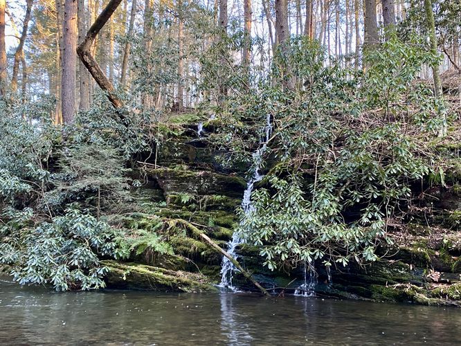
Rhododendron Falls - Mile 0.07
Only several-hundred feet into the hike, around mile 0.07, hikers will reach a brook-side waterfall that cascades down moss-covered rocks and surrounded by old rhododendrons -- this is the 15-foot waterfall known as Rhododendron Falls. While this cascade is thinner and quiet, unlike the waterfalls upstream, its tranquil and colorful backdrop of the moss, ferns, and rhododendron just add to the scenery within Van Campens Glen.
The trail will then meander its way eastward as it traverses over creek bedrock that can often be found wet, slick, and slippery, so watch your step.
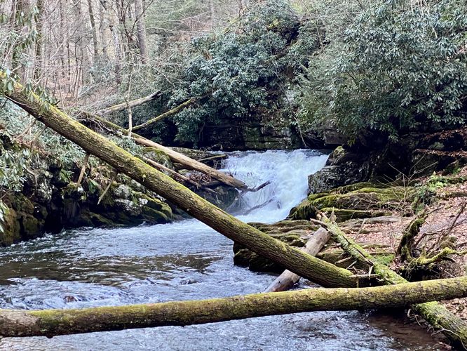
Lower Van Campens Glen Falls View - Mile 0.18
Around mile 0.18, hikers will be able to view Lower Glen Falls or Lower Van Campens Glen Falls, located upstream. Here, hikers will have the best view of the waterfall despite it being a couple-hundred feet away. There's no safe way to reach the base of the waterfall, but hikers can head up the wooden staircase of the trail to reach the top of the waterfall, as shown in this GPS track.
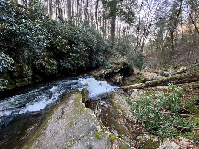
Top of Lower Van Campens Falls - Mile 0.22
After hiking the staircase and descending, hikers can head off-trail to reach the top of Lower Van Campens Glen Falls. The waterfall is about 12-feet tall in total and obviously the better view was downstream, but the view of the waterfall from the top provides beautiful scenery looking downstream into the Van Campens Glen.
Due to timing of daylight during my hike here, the GPS track ends at the top of Lower Falls; however, there's much more to explore along this trail if you want to hike the entire way out-and-back. This short 0.4-mile out-and-back hike is well-worth the walk to explore part of Van Campens Glen and its beautiful waterfalls.
Trails
This hike follows a section of the yellow-blazed Van Campens Glen Trail.
Parking
Note that the parking coordinates provided, located along Old Mine Road, will bring you to the entrance road for the parking lot. The parking lot sits at the end of this one-vehicle-wide dirt entrance road. The parking lot, as of December 2023, is large enough to fit a couple dozen vehicles.
Pets
Dogs are only allowed if leashed and must be cleaned up after.
Restrooms
This trail has non-flush restrooms at the trailhead.
Warning
Slippery bedrock: This trail follows bedrock along the bank of VanCampens Brook which can be slick and slippery when wet. Watch your step and hike at your own risk.
Trail Closure (2024)
As of 2024, this trail is inaccessible to the public due to a repaving and restructuring road construction project being done on Old Mine Road between Worthington State Forest and Millbrook Village. More information can be found here. Please inform us (Dave @ MyHikes) if/when the road re-opens and I'll update this note, thanks.
Trails
This hike follows one named trail: Van Campens Glen Trail (yellow blazes).
Hike Description
This hike begins at the lower parking lot for Van Campens Glen and follows the yellow blazed trail east as it passes through the moss and fern-filled forest of Van Campens Glen.
Rhododendron Falls - Mile 0.07
Only several-hundred feet into the hike, around mile 0.07, hikers will reach a brook-side waterfall that cascades down moss-covered rocks and surrounded by old rhododendrons -- this is the 15-foot waterfall known as Rhododendron Falls. While this cascade is thinner and quiet, unlike the waterfalls upstream, its tranquil and colorful backdrop of the moss, ferns, and rhododendron just add to the scenery within Van Campens Glen.
The trail will then meander its way eastward as it traverses over creek bedrock that can often be found wet, slick, and slippery, so watch your step.
Lower Van Campens Glen Falls View - Mile 0.18
Around mile 0.18, hikers will be able to view Lower Glen Falls or Lower Van Campens Glen Falls, located upstream. Here, hikers will have the best view of the waterfall despite it being a couple-hundred feet away. There's no safe way to reach the base of the waterfall, but hikers can head up the wooden staircase of the trail to reach the top of the waterfall, as shown in this GPS track.
Top of Lower Van Campens Falls - Mile 0.22
After hiking the staircase and descending, hikers can head off-trail to reach the top of Lower Van Campens Glen Falls. The waterfall is about 12-feet tall in total and obviously the better view was downstream, but the view of the waterfall from the top provides beautiful scenery looking downstream into the Van Campens Glen.
Due to timing of daylight during my hike here, the GPS track ends at the top of Lower Falls; however, there's much more to explore along this trail if you want to hike the entire way out-and-back. This short 0.4-mile out-and-back hike is well-worth the walk to explore part of Van Campens Glen and its beautiful waterfalls.
Trails
This hike follows a section of the yellow-blazed Van Campens Glen Trail.
Parking
Note that the parking coordinates provided, located along Old Mine Road, will bring you to the entrance road for the parking lot. The parking lot sits at the end of this one-vehicle-wide dirt entrance road. The parking lot, as of December 2023, is large enough to fit a couple dozen vehicles.
Pets
Dogs are only allowed if leashed and must be cleaned up after.
Restrooms
This trail has non-flush restrooms at the trailhead.
Warning
Slippery bedrock: This trail follows bedrock along the bank of VanCampens Brook which can be slick and slippery when wet. Watch your step and hike at your own risk.