Loading...

🎉 Enjoy a Free 7-Day Supporter Trial and Unlock Exclusive Perks — No Credit Card Required. Learn more.

Lower Sand Spring Falls

Directions
Map
Pictures
Send to App
Distance:
0.1 Miles / 0.2 km
Type:
Out-and-Back
Difficulty:
Easy
Time to Hike:
~5 minutes
Features:
Surface Type:
Dirt
Park:
Hickory Run State Park
Town:
Kidder Township, Pennsylvania
Directions:
41.023255, -75.710836
Added:
November 18, 2023
Updated:
January 04, 2024
Copy Trail Link Hiking this trail? Send a friend or family member a link to this trail guide for your own safety. Hike at your own risk (disclaimer)
Loading...
Loading...
8'

Total Change
8'

Ascent
8'

Descent

Download the Trail Route for Offline Use

Supporters get exclusive access to download trail routes to the MyHikes app for offline use. Stay prepared on your adventure, even without an internet connection! Become a Supporter today to unlock this feature and hike with confidence.

Send to App

Lower Sand Spring Falls

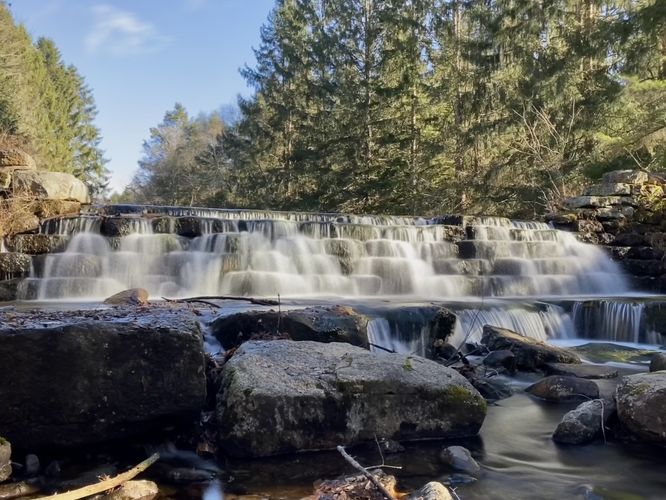
Lower Sand Spring Falls at Hickory Run State Park in Kidder Township, Pennsylvania is an easy 0.1-mile out-and-back walk that leads to the 6-foot tall waterfall, Lower Sand Spring Falls.

To get to Lower Sand Spring Falls, hikers will start at the parking turnout located on the east side of PA-534 at the parking coordinates provided, then walk south along the side of the road. Just a few-hundred feet down the road is the 6-foot tall, 30-foot wide waterfall known as Lower Sand Spring Falls. At the waterfall, visitors will find a small path that leads downhill to reach the base of the cascade. Lower Sand Spring Falls is an old reservoir wall that once held-back the creek to form a pond. At some point, Hickory Run State Park (or maybe the previous land owner) decided to remove the water barrier and to let the water flow once again, hence this is a human-made waterfall; however, it's still beautiful nonetheless.

Parking
Visitors will find a large parking turnout at the coordinates provided, located on the east side of PA-534 at the junction with McGinley Pond Road (service road).

Pets
Dogs are allowed only if leashed and must be cleaned up after.
Explore 20 trails near Kidder Township, PA
  1. Parking

    41.023255, -75.710836
  2. Main Trailhead

    41.023177, -75.711044
  3. Hickory Run Falls, approx. 6-feet tall 30-feet wide

    41.022543, -75.711671
    Hickory Run Falls, approx. 6-feet tall 30-feet wide
No community routes found. To add your own hike as a Community Route for this Trail guide, leave a Trip Report with an attached GPX file.

Hazards

Ticks - Lyme Disease More Info (CDC)

Seasons

All

Photo Albums

Trip Reports

Trail Guide By:
Admin user profile picture
0.1 miles / 0.2 km
0.1 miles / 0.2 km
November 19, 2023
Included this on my bigger loop around the entire park - definitely worth stopping at this beautiful spot, as is the dam by the Chapel across from Shades of Death trail!
Hiking
0.1 miles / 0.2 km
November 18, 2023
Small waterfall but scenic
Dogs Hiking

Weather Forecast

In Kidder Township, PA

Explore Hiking Trails

You May Also Like

Colorado's Million Dollar Highway - Plan a day's drive adventure along the iconic Million Dollar Highway in Colorado. Explore the best short trails, roadside stops, waterfalls, vistas, ghost towns, and hot springs within a ~6 hour road trip.
Explore

Colorado's Million Dollar Highway

Plan a day's drive adventure along the iconic Million Dollar Highway in Colorado. Explore the best short trails, roadside stops, waterfalls, vistas, ghost towns, and hot springs within a ~6 hour road trip.

Read
New York's Best Waterfalls - Whether you're planning a day hike, roadside stop, or a leisurely short walk, this guide provides hikers, travelers, and locals alike with 63 different locations to over 100 scenic waterfalls to help plan your next adventure!
Explore

New York's Best Waterfalls

Whether you're planning a day hike, roadside stop, or a leisurely short walk, this guide provides hikers, travelers, and locals alike with 63 different locations to over 100 scenic waterfalls to help plan your next adventure!

Read

Before you boogie...

Find our trail guides useful? Consider becoming a Supporter to unlock perks!

MyHikes is an indie platform that makes exploring public trails easier for everyone. The platform has no investors, no ads, and is owned and operated by one person, Dave Miller. Dave has personally mapped and written over 1,800 trail guides on MyHikes for the public to explore. MyHikes has helped millions outdoor enthusiasts plan their next adventure.

But it takes a lot of time 🕦, money 💰, work, and espresso shots ☕ to run MyHikes, including hiking , mapping , writing , and publishing new trails with high-quality (accurate) information... along with software engineering (coding) the platform like building new features, website and mobile app development (iOS and Android), site maintainance . and much much more.

Supporters unlock website and mobile app perks with an annual one-time payment of $25 (you renew) 😎👍. Or you can simply make a Donation of your choice. Otherwise, you can support us by telling your friends about MyHikes - both quick and free 🎉

Admin user profile picture

Dave Miller
MyHikes Founder