Lower Peck's Falls at Greylock Glen in Adams, Massachusetts is an easy 0.1-mile out-and-back hike that leads to the scenic 20-foot tall two-tiered waterfall, Lower Peck's Falls.
Hike Description
This hike begins at the unmarked trailhead along the northern side of West Mountain Road in Adams, MA -- right at the gas line -- and heads into the woods. As of December 2023, the overgrowth at the gas line was cut down and made for relatively easy hiking down the steep hillside here. Hikers will head into the woods heading east, following a trail that runs adjacent to Pecks Brook. Quickly, you'll hear the sounds of the cascading Lower Peck's Falls, where you can then hike to the edge of the cliffs / gorge to get a better view.
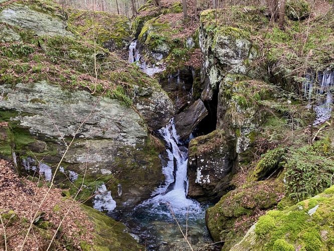
Lower Peck's Falls, approx. 20-feet tall - Mile 0.07
Less than 400-feet into the hike, around mile 0.07, hikers will reach the 20-foot tall two-tiered waterfall known as Lower Peck's Falls. Lower Peck's Falls is split into two separate cascades that make up the entire waterfall, each about 10-feet tall. The waterfall is relatively difficult to photograph as it cascades in different directions and sometimes appears to be tucked away behind the gorge's bedrocks. The viewpoint I found near the end of the trail data provided has a decent view of the entire waterfall, with some exceptions and when the leaves are off of the trees. This cascade might be harder to view during warmer months. Also watch your step here, as the gorge is fairly deep with some sheer ledges.
After exploring Lower Peck's Falls, hikers will hike back uphill and back to parking. The difficulty really should not be considered any more than "easy" but some hikers may find the uphill hike back moderate.
Parking
There is no real parking lot for this hike but rather a very very small parking turnout near the coordinates provided along West Mountain Road. The turnout is large enough for one or maybe two vehicles, max. The turnout is easy to find if you know what you're looking for -- as of December 2023, there were large yellow "gas pipeline" poles in the ground. Park next to these poles fully off of the road. This is your parking area and trailhead.
Pets
Dogs are allowed only if leashed and must be cleaned up after.
Warning
Steep gorge cliffs: The best view of Lower Peck's Falls sits alongside a slippery and steep gorge with sheer drop-offs. Watch your step and be extra careful when attempting to explore Lower Peck's Falls.
Hike Description
This hike begins at the unmarked trailhead along the northern side of West Mountain Road in Adams, MA -- right at the gas line -- and heads into the woods. As of December 2023, the overgrowth at the gas line was cut down and made for relatively easy hiking down the steep hillside here. Hikers will head into the woods heading east, following a trail that runs adjacent to Pecks Brook. Quickly, you'll hear the sounds of the cascading Lower Peck's Falls, where you can then hike to the edge of the cliffs / gorge to get a better view.
Lower Peck's Falls, approx. 20-feet tall - Mile 0.07
Less than 400-feet into the hike, around mile 0.07, hikers will reach the 20-foot tall two-tiered waterfall known as Lower Peck's Falls. Lower Peck's Falls is split into two separate cascades that make up the entire waterfall, each about 10-feet tall. The waterfall is relatively difficult to photograph as it cascades in different directions and sometimes appears to be tucked away behind the gorge's bedrocks. The viewpoint I found near the end of the trail data provided has a decent view of the entire waterfall, with some exceptions and when the leaves are off of the trees. This cascade might be harder to view during warmer months. Also watch your step here, as the gorge is fairly deep with some sheer ledges.
After exploring Lower Peck's Falls, hikers will hike back uphill and back to parking. The difficulty really should not be considered any more than "easy" but some hikers may find the uphill hike back moderate.
Parking
There is no real parking lot for this hike but rather a very very small parking turnout near the coordinates provided along West Mountain Road. The turnout is large enough for one or maybe two vehicles, max. The turnout is easy to find if you know what you're looking for -- as of December 2023, there were large yellow "gas pipeline" poles in the ground. Park next to these poles fully off of the road. This is your parking area and trailhead.
Pets
Dogs are allowed only if leashed and must be cleaned up after.
Warning
Steep gorge cliffs: The best view of Lower Peck's Falls sits alongside a slippery and steep gorge with sheer drop-offs. Watch your step and be extra careful when attempting to explore Lower Peck's Falls.