The Lower Falls Loop in Rochester, New York is an easy 0.9-mile loop hike that features views of the 70-foot tall waterfall, Lower Falls, within the Genesee River.
Hike
This hike begins at the Maplewood Rose Garden section of the Genesee Riverway Trail and follows the main pathway as it leads south to reach Driving Park Ave. Hikers will cross the street and enter Lower Falls Park as the paved trail leads downhill along a moderate grade.
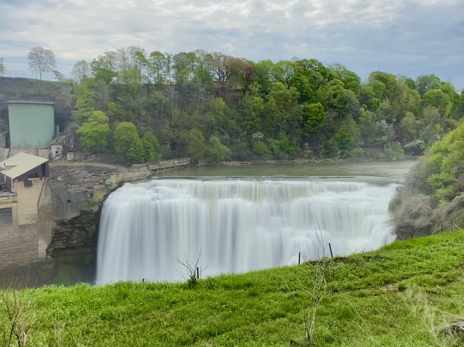
Lower Falls Views - Mile 0.25 to 0.4
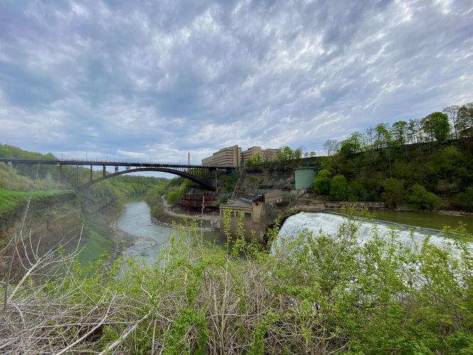
Hikers will reach the Lower Falls Park viewing areas shortly after, around mile 0.2. In this route, it leads you to the best view of Lower Falls first which is located downhill along the trail that leads back to parking. This viewpoint of Lower Falls, located around mile 0.25, is the best view you'll get but is unfortunately obstructed by the grassy cliff edge. The view of Lower Falls from here is also very misty as the massive waterfall sends plumes of mist into the air that surround the river's gorge and cliffs. The trail then leads to two viewpoints located at the very top of Lower Falls, around mile 0.35 and 0.4. Here, you'll find obstructed views from the top of the waterfall. You'll also find a massive swath of poison ivy growing just off-trail near where you'll want to attempt to take photographs, so watch out.
Middle Falls "View" - Mile 0.5
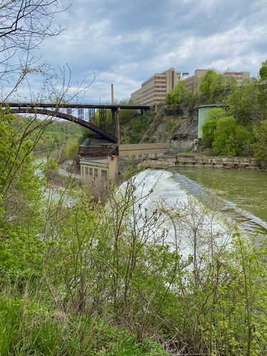
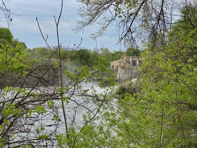
The trail then leads south through Lower Falls Park to create a small loop. At the very southern end of the park is an obstructed "view" of Middle Falls which can be seen cascading down the Genesee River adjacent to what appears to be a power plant. The "view" here is mostly obstructed, but provides one way to see Middle Falls.
Seat of Forgetting and Remembering - Mile 0.55
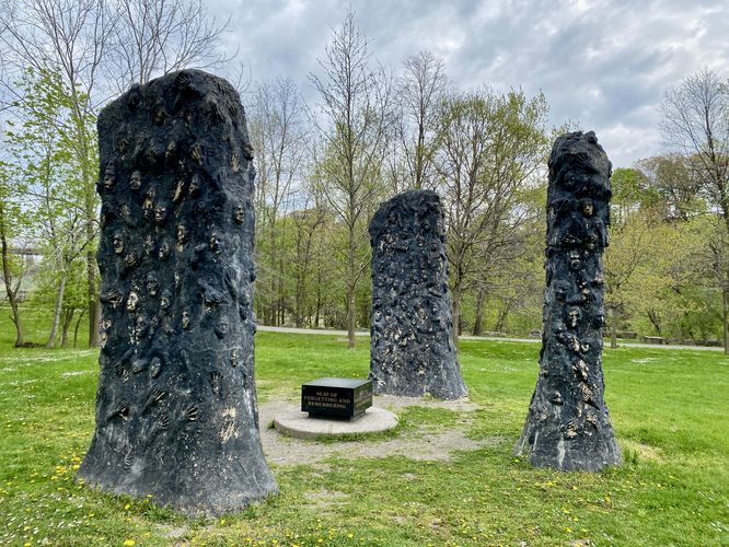
In the middle of Lower Falls Park is an art installation named the Seat of Forgetting and Remembering. The large pillars that surround the stone seat, located in the center, are covered in faces and hands. This somewhat creepy artwork is a neat addition to the waterfalls you'll find along the trail.
After exploring the waterfall views, the trail leads north along the eastern side of the loop. You'll once again pass the best view of Lower Falls, now located around mile 0.65 in this route, before the trail continues north along the western cliffs of the Genesee River. The trail passes under the large bridge overhead before it ascends back to parking. You'll be met with a short staircase climb to reach the parking lot to complete this 0.9-mile loop hike.
Universal Access
This trail is universally accessible for most of the route provided. From the parking lot (trailhead) and down to the waterfall area is universally accessible and follows paved trails. There are some steeper grades, especially heading down from the road to reach the waterfall viewing areas. The section that is not universally-accessible is on the hike out back to parking as this section of the route leads up a series of stairs to reach the parking lot.
Parking
Hikers will find a large parking lot at the coordinates provided, located on the north side of Driving Park Ave in Rochester, NY.
Pets
Dogs are allowed if leashed and should be cleaned up after.
Warning
Poison ivy: This trail has a crazy-amount of poison ivy located on the east side of the trail near the waterfall. Hikers should be aware of the large amounts of poison ivy that grow near the very-top of Lower Falls and spreads throughout the entire forest leading down toward the Genesee River. For this reason, we did not explore off-trail or near the "better" views of the waterfall by the river's edge.
Hike
This hike begins at the Maplewood Rose Garden section of the Genesee Riverway Trail and follows the main pathway as it leads south to reach Driving Park Ave. Hikers will cross the street and enter Lower Falls Park as the paved trail leads downhill along a moderate grade.
Lower Falls Views - Mile 0.25 to 0.4
Hikers will reach the Lower Falls Park viewing areas shortly after, around mile 0.2. In this route, it leads you to the best view of Lower Falls first which is located downhill along the trail that leads back to parking. This viewpoint of Lower Falls, located around mile 0.25, is the best view you'll get but is unfortunately obstructed by the grassy cliff edge. The view of Lower Falls from here is also very misty as the massive waterfall sends plumes of mist into the air that surround the river's gorge and cliffs. The trail then leads to two viewpoints located at the very top of Lower Falls, around mile 0.35 and 0.4. Here, you'll find obstructed views from the top of the waterfall. You'll also find a massive swath of poison ivy growing just off-trail near where you'll want to attempt to take photographs, so watch out.
Middle Falls "View" - Mile 0.5
The trail then leads south through Lower Falls Park to create a small loop. At the very southern end of the park is an obstructed "view" of Middle Falls which can be seen cascading down the Genesee River adjacent to what appears to be a power plant. The "view" here is mostly obstructed, but provides one way to see Middle Falls.
Seat of Forgetting and Remembering - Mile 0.55
In the middle of Lower Falls Park is an art installation named the Seat of Forgetting and Remembering. The large pillars that surround the stone seat, located in the center, are covered in faces and hands. This somewhat creepy artwork is a neat addition to the waterfalls you'll find along the trail.
After exploring the waterfall views, the trail leads north along the eastern side of the loop. You'll once again pass the best view of Lower Falls, now located around mile 0.65 in this route, before the trail continues north along the western cliffs of the Genesee River. The trail passes under the large bridge overhead before it ascends back to parking. You'll be met with a short staircase climb to reach the parking lot to complete this 0.9-mile loop hike.
Universal Access
This trail is universally accessible for most of the route provided. From the parking lot (trailhead) and down to the waterfall area is universally accessible and follows paved trails. There are some steeper grades, especially heading down from the road to reach the waterfall viewing areas. The section that is not universally-accessible is on the hike out back to parking as this section of the route leads up a series of stairs to reach the parking lot.
Parking
Hikers will find a large parking lot at the coordinates provided, located on the north side of Driving Park Ave in Rochester, NY.
Pets
Dogs are allowed if leashed and should be cleaned up after.
Warning
Poison ivy: This trail has a crazy-amount of poison ivy located on the east side of the trail near the waterfall. Hikers should be aware of the large amounts of poison ivy that grow near the very-top of Lower Falls and spreads throughout the entire forest leading down toward the Genesee River. For this reason, we did not explore off-trail or near the "better" views of the waterfall by the river's edge.