Loading...

🍂 Prep for Fall! Unlock exclusive features to plan your perfect late-summer and autumn hikes — become a Supporter today. Learn more.

Lower Dingmans Falls

Directions
Map
Pictures
Send to App
Distance:
0.1 Miles / 0.2 km
Type:
Out-and-Back
Difficulty:
Easy
Time to Hike:
~5 minutes
Features:
Surface Type:
Dirt
Park:
Delaware Water Gap National Recreation Area
Town:
Dingmans Ferry, Pennsylvania
Directions:
41.225008, -74.881157
Added:
December 12, 2023
Updated:
December 14, 2023
Copy Trail Link Hiking this trail? Send a friend or family member a link to this trail guide for your own safety. Hike at your own risk (disclaimer)
Loading...
Loading...
12'

Total Change
12'

Ascent
12'

Descent

Download the Trail Route for Offline Use

Supporters get exclusive access to download trail routes to the MyHikes app for offline use. Stay prepared on your adventure, even without an internet connection! Become a Supporter today to unlock this feature and hike with confidence.

Send to App

Key Takeaways

  • Lower Dingmans Falls is an easily accessible, scenic waterfall in Dingmans Ferry, PA, requiring only a 0.1-mile walk.
  • The waterfall is short, approximately 5 feet tall, but impressively wide at 45 feet, creating a beautiful view within Dingmans Creek.
  • Parking is available in two small turnouts near the falls, and leashed dogs are welcome, provided owners clean up after them.

Lower Dingmans Falls

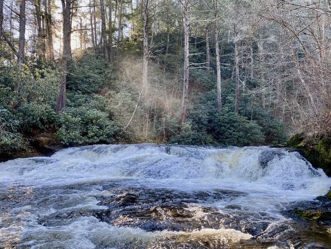
Lower Dingmans Falls at Delaware Water Gap National Recreation Area near Dingmans Ferry, Pennsylvania is an easy 0.1-mile out-and-back walk that features the scenic ~5-foot tall, 45-foot wide waterfall known as Lower Dingmans Falls.

This is not a hike but rather a very short roadside walk that leads to a beautiful view of the short, but scenic waterfall within Dingmans Creek. Lower Dingmans Falls is only 5-feet tall but spans ~45-feet wide across Dingmans Creek. Lining the opposite side of the creek are old rhododendrons that provide a stunning evergreen backdrop.

Parking
Visitors will find two parking turnouts -- one at the coordinates provided, located on the north side of DIngmans Falls Road. The other is located across the street in a very small parking lot. Both parking turnouts are large enough to just just a few vehicles each.

Pets
Dogs are allowed only if leashed and must be cleaned up after.
Explore 13 trails near Dingmans Ferry, PA
  1. Parking

    41.225008, -74.881157
  2. Main Trailhead

    41.224997, -74.881243
  3. Lower Dingmans Falls (approx. 5-feet tall, 45-feet wide

    41.224744, -74.881272
    Lower Dingmans Falls (approx. 5-feet tall, 45-feet wide
No community routes found. To add your own hike as a Community Route for this Trail guide, leave a Trip Report with an attached GPX file.

Hazards

Ticks - Lyme Disease More Info (CDC)
Poison Ivy/Oak

Seasons

All

Photo Albums

+ Add Photo Album

Upload your photos from the trail to help others know what to expect.

Preview of the MyHikes mobile app interface

Track, Log, and Explore Hikes with the MyHikes App

Explore Autumn Foliage

No Change
Some Color
Low Color
Moderate Color
High Color
Peak Color
Past Peak
Sept 1 Sept 8 Sept 15 Sept 22 Sept 29 Oct 6 Oct 13 Oct 20 Oct 27 Nov 3 Nov 10 Nov 17 Nov 24
Shop Landscape Prints
Shop our landscape prints from the Grand Canyon of Pennsylvania

Trip Reports (Reviews)

Rated 4.0 out of 5 based on 1 rating.

Let others know what to expect on the trail — be the first to leave a Trip Report (review) for this trail!

Weather Forecast

In Dingmans Ferry, PA

Explore Hiking Trails

You May Also Like

Colorado's Million Dollar Highway - Plan a day's drive adventure along the iconic Million Dollar Highway in Colorado. Explore the best short trails, roadside stops, waterfalls, vistas, ghost towns, and hot springs within a ~6 hour road trip.
Explore

Colorado's Million Dollar Highway

Plan a day's drive adventure along the iconic Million Dollar Highway in Colorado. Explore the best short trails, roadside stops, waterfalls, vistas, ghost towns, and hot springs within a ~6 hour road trip.

Read
New York's Best Waterfalls - Whether you're planning a day hike, roadside stop, or a leisurely short walk, this guide provides hikers, travelers, and locals alike with 63 different locations to over 100 scenic waterfalls to help plan your next adventure!
Explore

New York's Best Waterfalls

Whether you're planning a day hike, roadside stop, or a leisurely short walk, this guide provides hikers, travelers, and locals alike with 63 different locations to over 100 scenic waterfalls to help plan your next adventure!

Read

Before you boogie...

Find our trail guides useful? Consider becoming a Supporter to unlock perks!

MyHikes is an indie platform that makes exploring public trails easier for everyone. The platform has no investors, no ads, and is owned and operated by one person, Dave Miller. Dave has personally mapped and written over 1,800 trail guides on MyHikes for the public to explore. MyHikes has helped millions outdoor enthusiasts plan their next adventure.

But it takes a lot of time 🕦, money 💰, work, and espresso shots ☕ to run MyHikes, including hiking , mapping , writing , and publishing new trails with high-quality (accurate) information... along with software engineering (coding) the platform like building new features, website and mobile app development (iOS and Android), site maintainance . and much much more.

Supporters unlock website and mobile app perks with an annual one-time payment of $25 (you renew) 😎👍. Or you can simply make a Donation of your choice. Otherwise, you can support us by telling your friends about MyHikes - both quick and free 🎉

Admin user profile picture

Dave Miller
MyHikes Founder