Loading...

๐ŸŽ† 50% off 4th of July sale on Supporter Accounts โ€” now through July 6! Learn More.

Lower Cascade Falls Trail

Directions
Map
Pictures
Send to App
Distance:
0.3 Miles / 0.5 km
Type:
Out-and-Back
Difficulty:
Moderate
Time to Hike:
~9 minutes
Features:
Surface Type:
Dirt
Park:
Uncompahgre National Forest
Town:
Ouray, Colorado
Directions:
38.024858, -107.666883
Added:
June 03, 2024
Updated:
June 28, 2024
Copy Trail Link Hiking this trail? Send a friend or family member a link to this trail guide for your own safety. Hike at your own risk (disclaimer)
Loading...
Loading...
92'

Total Change
95'

Ascent
95'

Descent

Download the Trail Route for Offline Use

Supporters get exclusive access to download trail routes to the MyHikes app for offline use. Stay prepared on your adventure, even without an internet connection! Become a Supporter today to unlock this feature and hike with confidence.

Send to App

Lower Cascade Falls Trail

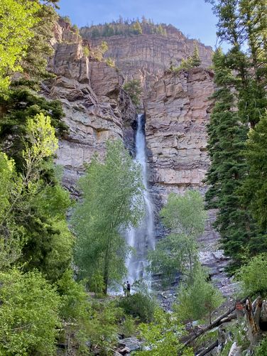
The Lower Cascade Falls Trail at Uncompahgre National Forest in Ouray, Colorado is a moderate 0.3-mile out-and-back hike that leads to the stunning ~330-foot tall waterfall known as Lower Cascade Falls.

Hike
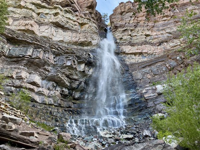
This hike begins at the end of the steep dirt road, 8th Ave in Ouray and follows the main trail uphill toward the waterfall. The trail is fairly steep, mostly dirt, with some rocks. It reaches a pavilion or picnic area just a few-hundred feet from the trailhead where hikers will find a beautiful downstream view of the waterfall. If you don't wish to hike any further, you don't have to, but the views from the base of the falls is much more impressive. The trail then leads across Cascade Creek via a footbridge before it continues heading eastward uphill toward the waterfall. Around mile 0.15, hikers will reach the base of Lower Cascade Falls where it plunges over the mountain cliffs at about 330-feet tall. The waterfall causes plenty of misting as the plumes of spray flow down the creek toward hikers downstream. After taking in the views (and photos) of Lower Cascade Falls, the trail leads back to parking for a short 0.3-mile out-and-back hike.

Restrooms
There are restrooms at the trailhead as of June 2024.

Parking
Hikers will find a large parking lot at the end of 8th Ave in Ouray at the dead end of the road. The lot is large enough to fit more than a dozen vehicles as of June 2024.

Pets
Dogs are allowed if leashed and should be cleaned up after.
Explore 18 trails near Ouray, CO
  1. Parking

    38.024858, -107.666883
  2. Main Trailhead

    38.024874, -107.666765
  3. Downstream view of Lower Cascade falls (330-feet tall)

    38.025208, -107.665406
    Downstream view of Lower Cascade falls (330-feet tall)
  4. Lower Cascade Falls, approx. 330-feet tall

    38.025636, -107.6651
    Lower Cascade Falls, approx. 330-feet tall
No community routes found. To add your own hike as a Community Route for this Trail guide, leave a Trip Report with an attached GPX file.

Seasons

All

Trip Reports

Trail Guide By:
Admin user profile picture
0.3 miles / 0.5 km
0.3 miles / 0.5 km
June 03, 2024
Hiking

Weather Forecast

In Ouray, CO

Explore Hiking Trails

You May Also Like

Colorado's Million Dollar Highway - Plan a day's drive adventure along the iconic Million Dollar Highway in Colorado. Explore the best short trails, roadside stops, waterfalls, vistas, ghost towns, and hot springs within a ~6 hour road trip.
Explore

Colorado's Million Dollar Highway

Plan a day's drive adventure along the iconic Million Dollar Highway in Colorado. Explore the best short trails, roadside stops, waterfalls, vistas, ghost towns, and hot springs within a ~6 hour road trip.

Read
Glacier's Going-to-the-Sun Road - Discover the breathtaking beauty of Glacier National Park along the iconic Going-to-the-Sun Road. From stunning roadside stops to picturesque waterfalls and vistas, this engineering marvel offers endless opportunities for exploration.
Explore

Glacier's Going-to-the-Sun Road

Discover the breathtaking beauty of Glacier National Park along the iconic Going-to-the-Sun Road. From stunning roadside stops to picturesque waterfalls and vistas, this engineering marvel offers endless opportunities for exploration.

Read
New York's Best Waterfalls - Whether you're planning a day hike, roadside stop, or a leisurely short walk, this guide provides hikers, travelers, and locals alike with 63 different locations to over 100 scenic waterfalls to help plan your next adventure!
Explore

New York's Best Waterfalls

Whether you're planning a day hike, roadside stop, or a leisurely short walk, this guide provides hikers, travelers, and locals alike with 63 different locations to over 100 scenic waterfalls to help plan your next adventure!

Read

Before you boogie...

Find our trail guides useful? Consider becoming a Supporter to unlock perks!

MyHikes is an indie platform that makes exploring public trails easier for everyone. The platform has no investors, no ads, and is owned and operated by one person, Dave Miller. Dave has personally mapped and written over 1,800 trail guides on MyHikes for the public to explore. MyHikes has helped millions outdoor enthusiasts plan their next adventure.

But it takes a lot of time ๐Ÿ•ฆ, money ๐Ÿ’ฐ, work, and espresso shots โ˜• to run MyHikes, including hiking , mapping , writing , and publishing new trails with high-quality (accurate) information... along with software engineering (coding) the platform like building new features, website and mobile app development (iOS and Android), site maintainance . and much much more.

Supporters unlock website and mobile app perks with an annual one-time payment of $25 (you renew) ๐Ÿ˜Ž๐Ÿ‘. Or you can simply make a Donation of your choice. Otherwise, you can support us by telling your friends about MyHikes - both quick and free ๐ŸŽ‰

Admin user profile picture

Dave Miller
MyHikes Founder